
O Arkajamie (Arkaimie), Arce, Arkonie i Ariach
Arkaim – Arkajama – nowy przypis 43 do Taji 19
43 Arkajama – Gród Wiedzy, gród-obwar uczonych – goryniczów-górów, mogtów i kapłów – w Górach Kamiennych, czyli Górach Ural (Gural, Horol). Leży w ramionach rzeki Karaganki i Utjaganki, w podgórskiej dolinie Arkajym na wschodnich stokach Uralu. Odkryty z kosmosu w roku 1982 i znany obecnie jako Arkaim (Arkajym)a. Zwraca uwagę związek nazwy rzeki z Górą i rzeką Kara występującymi w najważniejszych starych podaniach perskich o Świętej Górze Kara, Wyspie i Morzu Kara oraz Drzewie Wyspowiszub.

W Arkajamie-Arkaimie mieszkali i pracowali górowie-gorynicze – nauczyciele wszelkich kapłów, a więc wołchwów, kudiesników, zinisów, świtungów, mogtów-magów, kowów-kowalisów, burtników, czarowników i innych rodzajów kapłów Wiary Przyrodzonej, którzy byli zrzeszeni w kilkudziesięciu oddzielnych gromadach (grumadach). Tutaj w Arkajamie gorynicze i ich uczniowie zajmowali się badaniem Wszechświata, określali współzależności ruchów ciał niebieskich i ich wpływ na Ziemię (Matkę), Przyrodę (Rodżanę) i człowieka (Zerywanów). Swoich największych odkryć nigdzie nie zapisywali. Nie występowali też nigdy ze swoją wiedzą publicznie. Na podstawie wieloletnich obserwacji opracowywali tajemne rytuały, obliczali terminy, ustalali zasady obrzędów, ustalali sposoby postępowania – arkana, czyli w‑taje‑mniczenie w wiedzę (w Wiedę, wniknięcie w Wedę) i wprowadzali je w życie plemienne. Dalsze widzenia–wwiedzenia – czyli obserwacje, weryfikowały początkowe spostrzeżenia i pozwalały na wprowadzenie poprawek do świętych obrzedów czy też sposobów postępowania (wytopu, kowania, leczenia, zaklinania, itp.). Te nieustanne poprawki wprowadzane do wiedzy (Wiedy) doskonaliły ją do tego stopnia, że gorynicze i ich uczniowie-kapłowie potrafili w końcu wyrazić pełną wiedzę jednym twierdzeniem czy wywodem, albo jednym bądź dwoma krótkimi słowami, w których zawarta była istota tajemnego działania.

Wiedzę Tajemną (Arkana Wiedy) przekazywali gorynicze Arkajamy wyłącznie ustnie kilku swoim uczniom, których kształcili u swego boku przez długie lata. Ci uczniowie byli potem założycielami i mistrzami poszczególnych gromad kapłańskich (Grumad Kapłów), które różniły się od siebie zarówno zakresem wiedzy jak i narzędziami stosowanymi do jej pogłębiania i sposobami pośredniczenia w kontaktach między ludźmi a bogami, czy między żywymi a zmarłymi. Każda z gromad kapłów stosowała swoiste obrzędy magiczne, własne rytuały i sposoby czarownicze, wykorzystujące odpowiadający jej zakres wiedzy. Pod koniec życia ziemskiego gorynicz-góru (guru – to dosłownie będący górą, mieszkający w górach, pochodzący z gór, przedstawiciel świętej gromady kapłów-goroli, górujący wiedzą, gor– żar niecący, czyli wiedzący jak zapalać, niecić żar; wpierw dosłownie – żar-ogień, a potem w przenośni „żar-ogień” wiedzy i wiary), czyli mistrz – wyznaczał spośród członków gromad założonych przez swoich uczniów następcę, a sam udawał się w Zaświaty. Wyznaczał też następcę tymczasowego, kiedy okresowo przebywał w Zaświatach np. we wnętrzu Góry Kaganjątu (Kogajon – którą także niektórzy lokalizują w Górach Kamiennych, a nie w Bucegach). Także w miejscowym języku buriackim arka – znaczy osnowa, jądro, baza, podstawa. Słowo oral ma także znaczenia takie jak: oralny – wypowiadalny, głos, mowa, mowa główna, podstawowy język, czy horał – śpiewo-mowa uroczysta – święta. Przyjmuje się, że to tutaj w Arkajamie powstały pierwsze hymny Ryg-Wedy i Gathy (gadki) Awesty (Obwiesty), tutaj też zgłębiano tajniki geometrii, tajemnice liczb (czerty i czarowanie, butry-oboroty i burtowanie-obracanie), tajemnice znaków-pisów i wici (taje, bukwy, wikły), tajemnice ruchów ciał niebieskich, okresów Księżyca, zasady wytopu brązu, czy tajniki składu i działania ziół oraz trucizn.

Nazwę Arkajama (Arkajym, Arkaim) nosi święte wzgórze położone obok grodu-obwaru i znajdujące się tutaj święte, śródleśne uroczysko. Fakt, że w Arkajamie nie posługiwano się pismem świadczy o ortodoksyjnym przestrzeganiu zakazu używania taj – czyli znaków świętego pisma, czyli z jednej strony o surowym przestrzeganiu zasad Wiary Przyrodzonej, a z drugiej strony o tym, iż ośrodek arkajamski działał już po Wojnie o Taje. Kradzież nasion z Drzewa Wyspowiszu i zabicie Ryby Kary, a także wyniesienie tajemnicy pisma, ale przede wszystkim użycie tajemnego pisma przez Żar‑zduszta (Zaratusztrę) stało się powodem, opisanej w perskich kronikach, wojny między Skołotami (Sakami) a Persami. Głoszenie Obwiesty i przyjęcie Żar-zduszta na dworze Wisztaspęty (Witszaspy) w grodzie Bałh (Balch) nad Orolem i Bałhaszem, spowodowało niekończący się ciąg wojen między Królestwem Sis a Persami. To tam, w Bałhu, Żar-zdusz dokonał największej zbrodni – zapisu w języku huno-awarskim Obwiesty, czyli użył publicznie taj za co władca całego Wielkiego Kaganatu Sis wydał na niego wyrok śmierci. Był to tak poważny wyrok, że mimo ochrony władcy perskiego Żar-zduszt pod koniec długiego życia w dodtatku i zaszczytach zginął zamordowany podstępnie z rąk Czaropanów (Karopanów-Karpianów). Stąd też późniejsza wyprawa Darjusza, syna Wisztaspęty przeciw Skołotom (Scytom), stąd dalsze nie kończące się wojny o zasady wiary.

Zwraca uwagę związek nazewniczy między Arkajamą, Arkoną i samą Arką. Czy Arka jest identyczna ze szkatułą – Skrzynią, w której bogowie skołocko-istyjsko-słowiańscy przechowywali Taje – albo też czy jest tożsama z obłym workiem – Sakiem – widzialnym jako Biała Kula Światła, w którym przeniesiono Taje z Weli na Ziemię? Czy jest identyczna z Arką Pana – znaną z Biblii? Czy ci którzy skradli Taje Przeplątowi podczas wyprawy na Welę tutaj je ukryli – w Górach Kamiennych, a nie w Tajchu Beskidzkim, ani w innym miejscu: jak Schowek Harów (Hara-how, czy Góra Orza –znana dzisiaj jako Ararat? Należy pamiętać, że nazwa tych gór mogła by też znaczyć Góry Arki (Horol, Gorol, Haral, Goral, Góry, Hary Arki – Hara Arkayama). Góry Kamienne były też nazywane Górami Panów. Stąd, według podania, Panowie zostali przegnani przez Dziewannę i stali się Czaropanami (Haropanami, Panami Harpątów, czyli Karpat). Całość tego podania zawarta w Tai 23, pozostaje w zgodzie z danymi najnowszych odkryć genetyki dotyczącymi wędrówek Ludów Królestwa Sis (Słowian, Istów i Skołotów – ludów o haplogrupie R1a1). Także w Górach Horol i na wschód od tych gór mieszkały plemiona Saków – Wschodnich Skołotów (Wschodnich Scytów), niepokonanych nigdy przez Persów jako cały wieloplemienny szczep, od których pochodzą główne podania i legendy perskie i z których krwi pochodzili najwięksi perscy bohaterowie (boga-tyrowie, boga-tyrsowie), jak choćby, Żal (Zal-Zalazar) czy Rusłan (Rustam).

Arka-Jama to także jakby nazwa miejsca ukrycia Taj Wiary (Wiedy) Przyrodzonej – jama arki. W słowie arkajama po przestawieniu dwóch liter „rk” na „kr” (a przestawki u Słowian są częste, i były stosowane szczególnie w nazewnictwie wierzeniowym np. Weles-Wesel, jaro-rujo, Jarowit-Rujewit, zak-kaz, weń-naw i inne) zawiera się znaczenie „zakrycia” – ukry-joma, okry-joma, akra-jama. Słowo to wiąże się ze znaczeniem orzy – jarzęcy, świetlisty,święty, jarzący się, kwiecisty i gwieździsty, kiełkujący, świeży, młody, silny, ziarno, jądro, skąd orieh – orzech – jądro, oraz z samym mianem Ariów pochodzącym od Oryja – pierwszego władcy, albo Wyoranych na Zagonie Równi Welańskiej i Zerwanych a potem strąconych na Ziemię. Widać wyraźny związek słowa ory ze znaczeniem uprawy – orki, odkrywania, tajemnicy oraczy – rolników. Rdzeń or-orzy zawiera się w wielu nazwach miejscowych i plemiennych – jak choćby bliska nam Orawa i znana hetyckim zapisom Orzawa (Arzwa) w Małej Mazji (Azji). Rdzeń ten zawarty jest i w mianie totemowego ptaka Słowian – orła – orzego ptaka – słowiańskiego i sarmackiego godła (skołockim-sokołockim był sokół).

Czy Arkona i Rugia (Ruja, Roja, Oroja) – uważana przez badaczy za rodzaj pogańskiego państwa kościelnego była kontynuatorką tradycji Arkajamy? My twierdzimy, że tak. Była jej późniejszym odpowiednikiem, kształciła kapłów i była grodem świętym, rodzajem pogańskiego Rzymu dla świata barbarzyńskiego, czyli dla całego świata rozciągającego się na północ od linii Dunaju aż po wschodnie brzegi Mazji (Azji) – czyli Kamczatkę (Kończudkę).

Arkajama uchodzi za to miejsce, w którym narodziła się zarówno najstarsza wersja Wed (Wiedy, Ryg-weda, czyli Wiedza Ziarna, czy też Zboża, Wiedza Podstawowa, Zamknięta, Jądro Wiedzy, czy też równocześnie Wiedza pochodząca od Bogów – Zboża, Weda Boża, bo reg– zboże, sporze, żyto, ryż. Tutaj także miała się narodzic odszczepieńcza Awesta – Obwiesta, ogłoszona przez Żar-zdusza (Zaratusztrę), syna Burusza ze szczepu Mieniów-Kamieniów, z rodu Spisów zamieszkałych w Górach Kamiennych, w najstarszej wersji mało zrozumiałej dla Irańczyków, w języku huno-awarskim (czyli gunio-harskim, gunio-obryjskim). Stąd też wykradziono taje przekazane Romajom(Grekom i Rzymianom) i Mlekomedirowi (Egiptowi). Pierwszym zostały dane przez przyrodniego brata Lędy-Łabędy (Europy), syna Agi Nora i Jaśnieny II, albo przez Dziwnyjusza-Żalmoszysza (Dionizosa-Zalmoksisa), który był drugim ze złodziei nasion z Drzewa Wyspowiszu z Góry i Wyspy Kara. Drugim zostały przekazane przez Koszerysa znanego później w Indiach jako Kszatrij i w Melekomedirze jako Ozyrys. O ile w Windii i Mlekomedirze taje pozostawały w w ukryciu i nie były publicznie stosowane przez długie wieki (np. Wedy zostały spisane dopiero w 100 roku p.n.e. a wczesniej były przekazywane ustnie słowo w słowo tak jak Arkajamie, a w Egipcie tajemnice kapłańskie tak strzegły pisma, że dopiero niemal współczesni nam archeolodzy odczytali to pismo), o tyle Persowie i Romaje zaczęli go używać łamiąc Święty ZakaZ. Dlatego Wielka Skołotja (Scytia) i jej następczynie (Wielka Sarmacja i Słowiańszczyzna) znalazły się w odwiecznym konflikcie z Romajami i Persami. Windowie (Hindusi aryjscy) ani Mlekomedirzy (Egipcjanie) nie stali się wrogami Sistanu, bo dochowali tajemnicy Taj i uszanowali ZakaZ powszechnego posługiwania się znakami taj. ZakaZ ten był tak mocno przestrzegany w Królestwie Sis, że nie odnajdujemy do dzisiaj śladów pisma skołockiego (scytyjskiego) ani słowiańskiego (sarmackiego, serbo-mazowskiego), ani istyjskiego (bałtyjskiego), ani dracko-dawańskiego (tracko-dackiego) ze starożytności, mimo iż znane są słowa na określenie litery – bukwy, zapisu, księgi i inne potwierdzające znajomość pisma. Mimo bliskich związków i kontaktów, mimo bliskiego sąsiedztwa Scytów z Persami i Grekami znanych jest tylko kilkanaście do kilkudziesięciu inskrypcji i zapisów imion scytyjskich, które zostały wykonane przez Greków albo Persów. Dzisiaj dzięki licznym odkryciom archeologicznym coraz bardziej znany jest wysoki kunszt artystyczny i rzemieślniczy Scytów, ich głeboka znajomość sztuki wojennej, i narzędzi bojowych. Mimo tego, że ich wytwory w niczym nie ustępują wytworom greckim czy perskim Skołoci nie używali pisma a wiedzę przekazywali ustnie. Dlaczego?

O korzeniach tego konfliktu i wywołanych nim wojen zapomniano, ale naszym zdaniem Tamta Pierwotna Wojna – w niezliczonych odsłonach, wciąż odnawiana pod innymi pretekstami ideologicznymi, trwa od 4000 lat. Jest to naszym zdaniem prawdopodobnie odwieczna wojna między Aryjskim Wschodem (spadkobiercami R1a1 oraz zjednoczonymi z nimi przedstawicielami wenetyjskiej haplogrupy I2a2 – budowniczych megalitów Carnac [Czarniec] w Bretonii, w Stonhenge, nad Łabą i na Pomorzu Polskim) a Aryjskim Zachodem (spadkobiercami R1b1 i wenetyjskiej I1). Potwierdzają to mapy rozłożenia tych haplogrup w poszczególnych kulturach archeologicznych i ich zasięgi w epokach dziejowych. Jej ostatnim epizodem była II Wojna Światowa, której celem było zniszczenie Żydów i Słowian, a która skończyła się powrotem Królestwa Sis do tzw. Nowej Koliby – nad Łabę i Odrę oraz 50 letnim podziałem Niemiec. Być może współcześnie jesteśmy świadkami długotrwałego procesu pojednania i zjednoczenia tych dwóch odwiecznie rywalizujących o dominację stron.

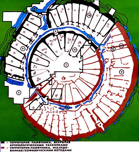
a W roku 1982 satelity przekazały na Ziemię fotografię kilku niezwykłych kręgów, wyraźnie wyodrębniających się na powierzchni stepu południowo-uralskiego. Te koncentryczne kręgi zostały zidentyfikowane jako jeden z najstarszych obiektów kultury indoeuropejskiej (aryjskiej). Sztuczne pochodzenie owych kręgów nie budziło od początku żadnych wątpliwości. Wiek znaleziska oceniono na około 1700 do 1600 p.n.e. Obecnie jest ono uważane za gród-obserwatorium zbudowany – podobnie do kręgu Stonehenge – na planie koła. Koło miało tutaj promień 160 metrów. Gród otaczała dwumetrowa fosa napełniona wodą. Zewnętrzne mury były bardzo masywne. Przy wysokości 5,5 metra miały grubość 5 metrów. W murach znajdowały się 4 wyjścia, usytuowane po przeciwległych stronach. Największe było południowo-zachodnie, pozostałe 3 – mniejsze. Wchodzący do miasta trafiał od razu na jedyną ulicę w kształcie pierścienia, szerokości około 5 metrów, oddzielającą pomieszczenia (domostwa) przylegające do zewnętrznego muru od wewnętrznego pierścienia. Ulicę stanowił zbudowany z okrągłych belek pomost. Wszystkie mieszkania przylegające do zewnętrznego muru jak cząsteczki cytryny miały wyjścia na główną ulicę. W sumie zidentyfikowano 35 oddzielnych domostw w kręgu zewnętrznym. Liczba ta jest zbyt mała nawet dla wioski.

Dalej odkryto tajemniczy pierścień murów wewnętrznych. Był on jeszcze potężniejszy aniżeli zewnętrzny. Miał szerokość 3 metrów, a jego wysokość osiągała 7 metrów. Mury te, według danych wykopaliskowych, nie posiadały przejść, poza jednym – od strony południowo-wschodniej. Tak więc 25 wewnętrznych domostw, identycznych jak te w okręgu zewnętrznym, było praktycznie odizolowane od reszty wysokim i grubym murem. Ażeby znaleźć maleńkie wejście do wewnętrznego kręgu, trzeba było przejść całą długość ulicy w kształcie pierścienia. Miało to ukryty sens. Wchodzący do obwaru musiał przejść drogę, którą przechodzi Słońce. Środek Arkajamy zajmuje centralny plac o kształcie nieomal kwadratowym, o wymiarach 25 na 27 metrów. Sądząc po śladach ognisk, usytuowanych według określonego porządku, był to plac przeznaczony do odprawiania tajemnych obrzędów związanych z Wiarą Przyrodzoną. W Arkajamie widzimy schemat mandali – kwadrat wpisany w koło. W starożytnych tekstach wierzeniowych koło symbolizuje Wszechświat, kwadrat Ziemię, nasz świat materialny. Ludzie już w starożytności na tyle dobrze znali strukturę Wszechświata i zdołali rozszyfrować zasady świętej geometrii, iż wiedzieli jak harmonijnie i naturalnie jest on urządzony. W trakcie budowy obwarów i grodów starali się więc odwzorować boski porządek Kłódzi, Weli i całego Wszechświata. W Arkajamie widać wyraźnie odwzorowanie struktury Kłódzi Swąta na Wierchu Weli.

Każde domostwo przylegało jedną stroną szczytową do zewnętrznego lub wewnętrznego muru i wychodziło na główną ulicę w kształcie pierścienia, albo na plac centralny. W zaimprowizowanym „przedpokoju” był specjalny odpływ wodny, który prowadził do kanału pod główną ulicą. Mieszkańcy tego miejsca byli więc już w głębokiej starożytności wyposażeni w kanalizację. Ponadto w każdym domostwie znajdowała się studnia, piec i nieduża spiżarnia w kształcie kopuły. Piec i studnia były połączone kanałem powietrznym dającym „cug” tak mocny, iż pozwalał na wytop miedzi bez dodatkowego używania miechów.
Średnica wewnętrznego kręgu Arkajamy stanowi wszędzie równe 85 metrów, w rzeczywistości jest to pierścień o dwóch promieniach: 40 i 43,2 metrów. Promień pierścienia „księżyc Obri” w Stonehenge wynosi 43,2 metra. I Stonehenge i Arkaim usytuowane są na tej samej szerokości geograficznej. Obydwa miejsca w centrum doliny w kształcie misy, a odległość między nimi wynosi prawie 4000km…
b Patrz Taja 23
 Z rosyjskiej książki Władimira Megre, „Rytuały miłości, Nowa Cywilizacja cz.2”
(tekst przetłumaczony trochę topornie, ale lepsze to niż nic)
„W roku 1952 satelity przekazały na Ziemię fotografię kilku niezwykłych kręgów, wyraźnie wyodrębniających się na powierzchni stepu południowo-uralskiego. Sztuczne pochodzenie owych kręgów nie budziło żadnych wątpliwości. Jednak nikt nie był w stanie powiedzieć dokładnie, cóż to takiego. (…) Wielu badaczy żywiło nadzieję na znalezienie pozostałości kraju, w którym żyła legendarna biała rasa aryjska. Badacze starali się chociażby zaledwie musnąć utraconą wiedzę, ten skarb będący w posiadaniu starożytnych aryjczyków.
Kiedy zaczęto prowadzić wykopaliska w dolinie arkaimskiej, archeologowie oznajmili światu naukowemu, iż zlokalizowali najstarszy gród, liczący ponad czterdzieści wieków, oraz że zamieszkiwali go ludzie najstarszej cywilizacji indoeuropejskiej. Badacze zaczęli nazywać Arkaim Miastem, Świątynią i Obserwatorium jednocześnie. (…)
-Arkaim – to jednak nie jest miasto ani świątynia. Co zaś się tyczy obserwatorium – tak, to prawda, jednak wcale nie jest to najważniejsze. Arkaim – to prawdopodobnie uczelnia, akademia jakby to można określić współcześnie. W Arkaimie mieszkali i pracowali nauczyciele wołchwów, kudiesników, zinisów, świtungów, mogtów-magów, kowów-kowalisów, burtników i czarowników oraz wszelkiego rodzaju innych kapłów Wiary Przyrodzonej . Tutaj zajmowali się oni badaniem Wszechświata, określali współzależności ciał kosmicznych, ich wpływ na człowieka. Swoich największych odkryć nigdzie nie zapisywali. Nie występowali też publicznie z długimi przemówieniami. Na podstawie wieloletnich obserwacji opracowywali rytuały, obliczali terminy, ustalali zasady obrzędów i wprowadzali je w życie ludzi, obserwując dalej na ile są one skuteczne. Kiedy było trzeba, wprowadzali poprawki. Wyniki tych długotrwałych prac byli w końcu w stanie wyrazić jednym bądź dwoma krótkimi słowami, w których zawarta była istota tajemnego działania. (…)
O tym, w jaki sposób prowadzono owe obserwacje czy badania, można by napisać wielotomowe traktaty.
Jednak wołchwowie ich nie spisywali i nie zamęczali ludzi swoją wiedzą: przedstawiali ludziom w kilku słowach gotowy wniosek. A ludzie wierzyli wołchwom, bo ich rady prawie zawsze potwierdzało życie. (…)
 Rekonstrukcja Arkajamy
Arkaim miał kształt koła o zewnętrznej średnicy około 160m. Jak widzimy dla miasta jest to zupełnie malutko – raczej należy nazywać go grodem. Jednak będę nazywać go miastem, jak to obecnie czynią naukowcy.
Otaczała go dwumetrowa fosa napełniona wodą. Zewnętrzne mury były bardzo masywne. Przy wysokości 5,5m miały grubość 5m. W murach znajdowały się 4 wyjścia, usytuowane po przeciwległych stronach. Największe było południowo-zachodnie, pozostałe 3 – mniejsze.
Wchodzący do miasta trafiał od razu na jedyną ulicę w kształcie pierścienia, szerokości ok. 5m, oddzielającą mieszkania przylegające do zewnętrznego muru od wewnętrznego pierścienia. Ulicę stanowił zbudowany z okrągłych belek pomost wpadał do kanału, po czym do zewnętrznego rowu.
Wszystkie mieszkania przylegające do zewnętrznego muru jak cząsteczki cytryny miały wyjścia na główną ulicę. W sumie wyznaczono 35 mieszkań w kręgu zewnętrznym. Liczba ta jest zbyt mała nawet dla wioski.
Dalej widzimy tajemniczy pierścień murów wewnętrznych. Był on jeszcze potężniejszy aniżeli zewnętrzny. Przy szerokości 3m jego wysokość osiągała 7m.
Mury te, wg danych wykopaliskowych, nie posiadały przejść, poza jedną niewielką wyrwą od strony południowo-wschodniej. Tak więc 25 wewnętrznych mieszkań, identycznych jak te w okręgu zewnętrznym, było praktycznie odizolowane od reszty wysokim i grubym murem. Ażeby znaleźć maleńkie wejście do wewnętrznego kręgu, trzeba było przejść całą długość ulicy w kształcie pierścienia. Miało to ukryty sens. Wchodzący do miasta musiał przejść drogę, którą przechodzi Słońce. Środek Arkaimu zajmuje centralny plac w kształcie nieomal kwadratowym. ok. 25x27m. Sądząc po śladach ognisk, usytuowanych według określonego porządku, był to plac przeznaczony do odprawiania jakichś rytuałów. Tak więc widzimy schemat mandali – kwadrat wpisany w koło. W starożytnych tekstach kosmogonicznych koło symbolizuje Wszechświat, kwadrat Ziemię, nasz świat materialny. Mądry człowiek starożytny, doskonale znający strukturę Kosmosu, widział, jak harmonijnie i naturalnie jest on urządzony. I dlatego w trakcie budowy miasta jakby od nowa stwarzał Wszechświat w miniaturze.
Arkaim wzniesiony był według wcześniej sporządzonego projektu, jako kompleks złożony z obiektów z największą dokładnością zorientowanych względem swoich astronomicznych odpowiedników. Układ 4 wejść w zewnętrznym murze Arkaimu przedstawia swastykę skierowaną zgodnie z ruchem Słońca.
Swastyka (w sanskrycie: „związana z łaską”, „największy sukces”) to jeden z najbardziej archaicznych symboli sakralnych, spotykanych już w okresie górnego paleolitu wśród wielu ludów świata. (…) Swastyka to symbol Słońca, sukcesu powodzenia, szczęścia, twórczości. I odpowiednio: swastyka skierowana w przeciwnym kierunku (odwrócona), symbolizuje ciemność, zniszczenie, „nocne Słońce” u dawnych Rusów. Jak widać na starych ornamentach, również na aryjskich dzbanach znalezionych w okolicach Arkaimu, używano obu swastyk. Ma to głęboki sens. Dzień następuje po nocy, światło nadchodzi po ciemności, nowe narodziny zastępują śmierć – i to jest naturalna kolej rzeczy we Wszechświecie. Dlatego w starożytności nie było „złych” i „dobrych” swastyk – odbierano je jako jedność.
 Rekonstrukcja Atlantis
Arkaim z zewnątrz był piękny: miasto na planie idealnego koła, z wyodrębnionymi basztami przy wejściach, płonącymi ogniami i pięknie ukształtowaną „fasadą”. Lecz z pewnością stanowił on jakiś sakralny wzór, niosący głęboki sens. Wszak wszystko w Arkaimie przeniknięte jest sensem.
Każde mieszkanie przylegało jedną stroną szczytową do zewnętrznego lub wewnętrznego muru i wychodziło na główną ulicę w kształcie pierścienia albo na plac centralny. W zaimprowizowanym „przedpokoju” był specjalny odpływ wodny, który prowadził do kanału pod główną ulicą. Starożytni aryjczycy byli więc wyposażenie w kanalizację. Ponadto w każdym mieszkaniu znajdowała się studnia, piec i nieduża spiżarnia w kształcie kopuły.
Ze studni nad poziomem wody wyprowadzone były dwa odgałęzienia rur wydrążonych w ziemi. Jedna doprowadzona była do pieca, a druga do spiżarni w kształcie kopuły. A w jakim celu? Wszystko jest genialnie proste. Dobrze wiemy, że jeśli zajrzeć do studni, zawsze ciągnie od niej chłodne powietrze. Dochodząc do pieca, to chłodne powietrze tworzy cug, o takiej sile, że pozwalało to na wytop brązu bez posługiwania się miechami! Taki piec był w każdym mieszkaniu. Kowalom pozostawało tylko cyzelowanie mistrzostwa i współzawodniczenie w swojej sztuce. Druga „rura ziemna” doprowadzona była do spiżarni i zapewniała jej obniżoną temperaturę.
Znany rosyjski astroarcheolog K. Bystruszkin prowadził badania nad Arkaimem jako obserwatorium astronomicznym i doszedł do następujących wniosków:
Arkaim to budowla, która nie jest wcale skomplikowana, jest wręcz nadzwyczaj złożona. W trakcie studiowania planu praktycznie od razu określono jego podobieństwo do znanych budowli Stonehenge w Anglii. Na przykład średnica wewnętrznego kręgu Arkaimu stanowi wszędzie równe 85 metrów, w rzeczywistości jest to pierścień o dwóch promieniach: 40 i 43,2m (spróbujcie wykreślić!) Natomiast promień pierścienia „księżyc Obri” w Stonehenge wynosi 43,2m. I Stonehenge i Arkaim usytuowane są na tej samej szerokości geograficznej. Oba w centrum doliny w kształcie misy, a między nimi odległość prawie 4000km…
(…)

Gród obwar oparty na okręgu w Iranie
Tak więc Arkaim jako obserwatorium astronomiczne służył również do obserwacji Księżyca. W sumie na owych ogromnych murach-kręgach można było zarejestrować 18 wydarzeń astronomicznych! Sześć związanych ze Słońcem i dwanaście związanych z Księżycem (włączając „wysoki” i „niski” Księżyc). Dla porównania badaczom Stonehenge udało się wyodrębnić tylko 15 wydarzeń niebieskich.
Oprócz tego uzyskano następujące dane: arkaimska miara długości – 80cm, środek wewnętrznego okręgu przesunięty jest względem zewnętrznego o 5,25 jednostek arkaimskiej miary, co jest bliskie kąta nachylenia orbity Księżyca – 5 stopni plus-minus 9-10minut. Zdaniem K. Bystruszkina, wyraża to stosunek pomiędzy orbitami Księżyca i Słońca (dla ziemskiego obserwatora). Odpowiednio, zewnętrzny okrąg Arkaimu poświęcony jest Księżycowi a wewnętrzny Słońcu. Ponadto pomiary astroarcheologiczne ukazały związek niektórych parametrów Arkaimu z precesją osi ziemskiej, a to już wyższa szkoła jazdy nawet we współczesnej astronomiii.
Tak więc widzimy: Arkaim, nawet z dużym marginesem błędu, nie przystaje do określenia 'miasto’. W bardzo małym pokoiku nie ma możliwości ulokowania się wraz z rodziną. Dla filozoficznych rozmyślań natomiast – jest to przestrzeń idealna.
To, iż w starożytności wołchwowie uważani byli za mędrców i nauczycieli – historykom jest wiadome. Arkaim, mógł należeć tylko do wołchwów, czyli najogólniej określając tę gromadę „wiedzących” – do kapłów-mistrzów, goryniczów – dzisiaj powiedzielibyśmy” oświeconych” – guru. Innych „uczonych obserwatorów” w owych czasach po prostu nie było.
To, iż wołchwowie wyliczyli odpowiedni czas i opracowali rytuały, nanosząc coraz nowe korekty na podstawie ciągłych obserwacji kosmosu jest wiadome, ale pojawia Si pytanie co takiego się stało, że zostały całkowicie zaniedbane i zapomniane.
Tekst pochodzi ze strony: http://www.historycy.org
 Mandala staroaryjska
Arkaim – największa rosyjska tajemnica
Wśród znawców miejsce to uchodzi za jedno z najbardziej tajemniczych i aktywnych paranormalnie na świecie. Arkaim to położona na Uralu, w obwodzie czelabińskim prastara twierdza, która określana bywa mianem rosyjskiego Stonehenge. Mimo że obiekt poddawany był wielu badaniom, większość zjawisk, które mają tam miejsce pozostaje niewyjaśniona. Przerażenie budzą zaś tragiczne wydarzenia, do jakich w przeszłości wielokrotnie dochodziło w okolicy.

Zdaniem naukowców, forteca została wybudowana w epoce brązu i stanowi dziedzictwo kultury andronowskiej. Odkryto ją przypadkowo w 1987 r. podczas prac przygotowawczych, poprzedzających budowę planowanego w tym miejscu zbiornika retencyjnego. Budowla zawiera portale skierowane w cztery strony świata. Zdaniem naukowców, stanowi ona także rodzaj bardzo precyzyjnego kalendarza odnoszącego się do najważniejszych wydarzeń astronomicznych. Zdaniem ekspertów, kalendarz ten odzwierciedla 18 najistotniejszych zjawisk astronomicznych.
Nie ma pełnej zgody specjalistów, co do roli, jaką konstrukcja pełniła w przeszłości. Niektórzy twierdzą, że była to osada lub miasto; inni mówią o funkcji obserwatorium albo świątyni. Zainteresowanie większości osób budzi natomiast fakt, że struktura została wzniesiona na planie swastyki i często określana bywa mianem miasta-swastyki. Wg specjalistów, budowla mogła pomieścić nawet 2,5 tysiąca osób.
Na przestrzeni lat, w miejscu tym wielokrotnie dochodziło do tajemniczych zdarzeń. Jakiś czas temu, jedna ze studentek archeologii, która zajmowała się badaniem obiektu wyznała, że znajdując się w jego okolicy nawiązała kontakt… z duchami osób, które żyły tam dawno temu, a od których miała się dowiedzieć wielu intrygujących rzeczy. Niestety, jakiś czas po tych wydarzeniach uznano ją za niepoczytalną. Wkrótce potem, w miejsce to został wysłany archeolog Konstantin Bystruszkin. Naukowiec przez lata zajmował się badaniem tajemniczego miejsca, ale zamiast wyjaśnić przynajmniej część tajemnicy, odkrył cały szereg kolejnych fenomenów.
Badacze rosyjskiego Stonehenge zwracają uwagę, że wokół obiektu zawsze krążyły dziwne opowieści. Oprócz historii o duchach, dziwnych postaciach i Niezidentyfikowanych Obiektach Latających, którym przypisuje się związek z konstrukcją, w przeszłości popularne były też legendy, że Arkaim znajduje się na skraju znanej rzeczywistości, a przekroczenie jego murów może spowodować przemieszczenie się do innego miejsca.
Nie można w końcu zapomnieć o właściwościach, które niektóre społeczności przypisują murom starożytnej twierdzy. Do miejsca tego wciąż pielgrzymują tłumy. Wiele osób wierzyło, że odprawienie tam specjalnych rytuałów zaowocuje ziszczeniem się wszelkich życzeń. Obok fortecy znajduje się kilka ułożonych z kamieni spirali. Zgodnie z przesądem, wejście do którejś z nich boso lub najlepiej nago i wypowiedzenia życzenia w centralnej jej części, powinno pomóc w realizacji życzenia.
Wiara w to, że w miejscu tym działają potężne siły mobilizuje też ludzi chorych, którzy tłumnie przybywają, by wyleczyć się z rozmaitych dolegliwości. Wielu pielgrzymów twierdzi, że po wizycie w tym miejscu udało im się pozbyć chorób skóry.
Arkaim jest ściśle powiązany z trzema innymi miejscami położonymi wokół twierdzy. – informuje serwis pravda.ru. Pierwsze z nich jest celem turystycznych eskapad; w drugim wciąż trwają prace wykopaliskowe; natomiast w trzecim dochodzi do rzeczy tak przerażających, że wielu ludzi unika go jak ognia. W przeszłości miało w nim dochodzić do rzeczy rodem z horrorów, a obecne tam olbrzymie pokłady energii miały w dwojaki sposób oddziaływać na wszystkie przebywające tam osoby – czasami pozytywnie, a innym razem negatywnie.
Nie brakuje relacji o tajemniczych zniknięciach, do których dochodziło w pobliżu budowli. Pod koniec ubiegłego roku doszło tam do dziwnego zdarzenia. Dziewczyna, która wybrała się w okolice konstrukcji z dwoma przyjaciółmi była rzekomo ścigana przez tajemnicze światła. Dziewczyny nigdy nie udało się odnaleźć, zaś młodzieńcy, którzy jej towarzyszyli byli sparaliżowani tym co zobaczyli. To właśnie nieopodal tego miejsca doszło w końcu do słynnej tragedii, kiedy to dziewięcioro uczestników górskiej wyprawy zginęło w niewyjaśnionych okolicznościach na stoku góry Cholat Sjakl. Miejsce, w którym doszło do tragedii znane jest dziś jako Przełęcz Diatłowa.
W 2005 r. z wizytą w miejscu tajemniczych zdarzeń przebywał ówczesny prezydent Rosji Władimir Putin.
tekst ze strony: http://niewiarygodne.pl/kat,1017181,title,Arkaim-najwieksza-rosyjska-tajemnica,wid,12355821,wiadomosc.html
Filmy o Arkajamie – Arkaimie

Słowiańskie runy – od Atlantów i Arkaimu po dzisiaj:
część 3
http://www.youtube.com/watch?v=kp_d8EstjwI&feature=related
część 4
http://www.youtube.com/watch?v=APKYVp348wg
część 5
http://www.youtube.com/watch?v=QB7xK_G85D8&feature=related
Na długo przed Arkaimem Ariowie:
część 6
http://www.youtube.com/watch?v=vNNns4F7yXI&feature=related

O Arkaimie w ogóle:
arkaim część 1
http://www.youtube.com/watch?v=e7noXqRsiEY&feature=related
część 2
http://www.youtube.com/watch?v=GN9E-rDtBBM&feature=related
 Ariowie zniszczywszy starożytną kulturę Doliny Indusu podobno czcili swoich bogów pod gołym niebem a pierwsze stupy zbudowali buddyści. Tak twierdzi nauka, ale to chyba nie jest prawda. C. B.
♦
O Ariach z Wikipedii
Ariowie (albo Indo-Irańczycy) – odłam ludów indoeuropejskich, który w III i II tysiącleciu p.n.e. zamieszkiwał Azję Środkową, by następnie rozprzestrzenić się na tereny Iranu i Indii.
Ariowie wyodrębnili się z indoeuropejskiej rodziny językowej prawdopodobnie około połowy III tysiąclecia p.n.e., a już około 2000 p.n.e. ich język stracił wszelki z nią kontakt. Oznacza to, że ich migracja z pierwotnych terytoriów, prawdopodobnie mniej więcej dzisiejszego Kazachstanu [1], musiała rozpocząć się już wcześniej.
Według Anatola Klosowa, który swoje badania oparł na datowaniu szczątków kopalnych z wykrytą haplogrupą Y-DNA R1a1, ok. 2300 p.n.e odłam ludu indoeuropejskiego zamieszkującego na terenach obecnej europejskiej Rosji i Ukrainy przemieścił się na wschód, na teren dzisiejszego Kazachstanu i południowego Uralu, tworząc tam kulturę andronowską. Około 1800 p.n.e zbudowali gród Arkaim na południu Uralu. Ok. 1600 p.n.e mieszkańcy porzucili Arkaim przemieszczając się na południe, na tereny obecnej Kirgizji i Tadżykistanu, a następnie Indii i Iranu.[2].
Ariowie prowadzili półkoczowniczy tryb życia, a źródłem ich przewagi militarnej był udomowiony przez nich koń, którego zaprzęgali do rydwanów. Ich społeczeństwo dzieliło się na trzy klasy – kapłanów, wojowników i wytwórców, odpowiadające późniejszym hinduskim braminom, kszatrijom i wajśjom. Obecność klasy kapłanów wiąże się z silnie zrytualizowanym charakterem ich religii, która opierała się na składaniu krwawych ofiar i sprawowaniu obrzędów związanych z kultem świętego napoju Homy (indyjskiej Somy). Wierzyli oni także w życie pozagrobowe i czcili rozbudowany panteon bóstw.
W nauce walczą ze sobą zwolennicy dwóch hipotez odnośnie trasy wędrówki Ariów do Iranu – przez Azję Środkową, albo przez Kaukaz. Obie mają za sobą silne argumenty pochodzące zarówno z badań archeologicznych, jak i tekstów źródłowych. Dlatego niektórzy historycy proponują, by przyjąć, iż Ariowie docierali na teren dzisiejszego Iranu obiema drogami [3].
Jest jednak faktem niepodważalnym, że w trakcie wędrówki Ariowie podzielili się na dwie grupy – irańską, która przybyła do dzisiejszego Iranu, i indyjską, która powędrowała do Indii. W okresie od XIX do XIV wieku p.n.e. rozprzestrzenili się na terenie doliny Indusu, wypierając z niej inne ludy – prawdopodobnie Drawidów. W późniejszym okresie zasiedlili cały Półwysep Indyjski, dziś są uważani za przodków większości Indusów.
Już z XVIII w. p.n.e. posiadamy źródła mówiące o kontaktach Ariów z Hurytami, z którymi następnie przemieszali się i wspólnie utworzyli państwo Mitanni. Część Ariów, która nie pozostała w północnej Mezopotamii, wyruszyła na tereny dzisiejszego Azerbejdżanu (ok. 1300 p.n.e.) – byli to poprzednicy Medów. Od nich oddzieliła się grupa podążająca na południe zachodniego Iranu – byli to protoplaści Persów. Ariowie wyparli lub zdominowali poprzedzającą ich ludność i zajęli jej miejsce.
Ponieważ więcej poważnych ani nawet niepoważnych tekstów o Arkajamie-Arkaimie – będącym wszak odkryciem porównywalnym ze Stonehenge – w języku polskim nie znajduję, przytaczam poniżej teksty rosyjskie i angielskie dla tych którzy znają te języki albo dla tych którzy mogą wyciągnąć choćby odrobinę informacji z ułomnych tłumaczeń przez programy tłumaczące Google albo inne programy translatorskie.
 Kręgi w Arkaimie
Некрополь Аркаим
АРКАИМ (Арkайым), археол. комплекс, включающий укрепленное поселение и прилегающие хоз. площадки, могильник, ряд неукрепленных селищ. Назв. „А.” (возможно, от тюрк. (баш.) „арка” („арkа”) – „хребет”, „спина”, „основа”) дано по названию сопки и урочища. Комплекс расположен в Челябинской обл., (на терр. ист. Башкортостана), на р.Б.Караганка, и ее лев. притоке р.Утяганке, в предгорной долине у вост. склонов Уральских гор. Пам. датируется 2-й четв. 2-го тыс. до н.э. (17-16 вв. до н.э.). Радиоуглеродные даты – 3600-3900 лет тому назад. Комплекс исследуется с 1987 археол. экспедицией Челябинского ун-та под руководством Г.Б.Здановича.

Аркаим (аэрофотосъемка)
Укрепленное поселение А. Общая пл. 20000 м2. Пл. археол. раскопов (на 1993) – 8055 м2. Геофиз. иссл. проведены на пл. 7600 м2. Поселение фиксируется в виде двух, вписанных друг в друга, колец земляных валов с 4 проходами внеш. рва, двух кругов жилищных впадин и центр. площадью (рис.1). Валы являются остатками оборонительных стен, сложенных из грунта, сырцовых блоков и дерева. Диаметр внутр. стены (стены цитадели) – 85 м, внеш. – 143-145 м, толщина стен по основанию – от 3 до 5 м, высота грунтовой ч. в древности была не менее 3-3,5 м. К фортификационным сооружениям относятся радиальные стены, к-рые разбивали внеш. кольцо жилищ на 5 или 7 секторов. Жилища в плане трапециевидные, наземные, по 110-180 м2, сооружены из бревенчатых каркасов и грунтовых блоков. Смежные жилища имели общие длинные стены. Ок. 1/3 пл. жилища отводилось под общее пользование. Здесь расположены колодец, погреб, очаг, совмещенный с металлург. печью. Жилища цитадели обращены выходами к центр. площади. Пл. имела прямоугольную форму (25х27 м) и предназначалась, очевидно, для ритуальных действий. Жилища внеш. кольца обращены выходами к круговой ул., к-рая связывала все входы в пос. и все жилища с центр. площадью. Под настилом круговой ул. обнаружен ров ливневой канализации со сточными колодцами. На поселении археол. раскопами исследовано 29 жилищ: 17 во внеш. и 12 во внутр. круге. Геофизич. методами установлено, что всего во внеш. круге было 35 жилищ, во внутр. – 25 (19 – больших и 6 небольших, встроенных между осн. жилищами в процессе роста нас.). Собрано 9 тыс. фрагментов керамики, изделия из кости и камня, орудия из металла (ножи с перехватом, серпы-струги, шилья, украшения), мн. предметов, связанных с металлургией и металлообработкой: литейные формы, шлаки, сопла, молотки и наковальни. Насыщенность культ. слоя материальными остатками невелика. Х-во нас. А. базировалось на пастушеском скот-ве с элементами земледелия. 96% палеозоологических находок составляют кости домашних ж-ных: 60-65% – кр. рогатого скота, 20-25% – мелкого рогатого скота, 15% – лошадей. На терр. аркаимской долины в радиусе 5-6 км от укрепленного ц. зафиксировано не менее 5 многослойных поселений бронзового века с остатками слоев 17-16 вв. до н.э. Вероятно, это были небольшие по размерам поселения без фортификац. сооружений. Не исключено, что с укрепленным ц. были связаны и более удаленные неукрепленные поселения.

Общий план поселения Аркаим.
Могильник А. расположен на лев. берегу р. Б.Караганка, в 1-1,5 км к С.-В. от поселения А. Исследовано 5 курганов. Господствующее положение в могильнике занимают крупные, диаметром 17-19 м, могильные поля, объединяющие 12-20 ям. Своеобразие погребальной архитектуры определяют глубокие – до 3,5 м – могильные ямы с обширными полыми погребальными камерами, уступами, неск. деревянными перекрытиями. Сверху ямы были перекрыты индивид. грунтовыми насыпными конструкциями, либо ложносводчатыми куполами из глинобитных блоков. Захоронения в ямах одиночные, парные, групповые; трупоположение на боку, в слабо- или среднескорченном положении. Антропологич. тип погребенных – протоевропеоидный. Погребения сопровождаются богатым инвентарем, особенно в центр. ямах: бронз. листовидные ножи, топоры-тесла, долота, шилья, гарпун, наконечник копья, др. изделия из бронзы, наконечники стрел из камня и кости, каменная булава, принадлежности конской упряжи, украшения и т.д. В керамических комплексах доминируют острореберные горшки, украшенные геометрич. орнаментом. Многочисленны остатки жертвенных ж-ных (лошадь, кр. и мелкий рогатый скот, собака). Исследованы также могильные поля, объединяющие по 7-8 могильных ям со сравнительно бедным погребальным инвентарем.
Культурный комплекс А. входит в группу укрепленных поселений Южн. Урала, названную „Страной городов”. Она расположена к Ю. от р.Уй, занимает, в осн., водораздел рек Урал и Тобол. „Страна городов” состоит из двух десятков комплексов. Протяженность занимаемой терр. 350-400 км в направлении С.-Ю. и 120-150 км – З.-В. Расстояние между одноврем. существовавшими укрепленными пос. составляло 50-70 км. Радиус освоенной терр. соответствовал 25-35 км (пл. ок. 2000 км2). Культурные комплексы аркаимского (синташтинского) (см. Синташта) типа с их иерархией поселений и могильников целесообразно рассматривать как террит. образования с элементами ранней государственности, близкие к „вождеству” или „чифдому”.
Лит.: Зданович Г.Б. Феномен протоцивилизации бронзового века Урало-Казахстанских степей. Культ. и соц. обусловленность //Взаимодействие кочевых культур и древних цивилизаций. Алма-Ата, 1989; его же. Архитектура поселения Аркаим //Маргулановские чтения. Сб. материалов конф. Москва, 1992; его же. Аркаим: арии на Урале. Гипотеза или установленный факт? //Фантастика и наука (Гипотезы. Прогнозы). Международный ежегодник. Вып.25. М., 1992.
Г.Б.Зданович.
© Д.Н. Верхотуров

АРКАИМ: НЕСЧАСТЛИВОЕ ОТКРЫТИЕ
Аркаим – как один из самых известных памятников синташтинской культуры бронзового века на Южном Урале, в бассейне Урала, вызвал к себе огромный научный и ненаучный интерес, множество публикаций и огромное количество самых разнообразных теорий и гипотез, большая часть которых к самому Аркаиму имеет самое косвенное отношение.
С момента начала раскопок первых памятников, да и самого Аркаима прошло уже достаточно много времени, чтобы рассмотреть не только сами материалы раскопок уникальных городищ и могильников, но и сложившиеся вокруг них научные и ненаучные феномены, через призму которых сейчас нередко оцениваются материалы этих уникальных комплексов.
Рассматривая историю изучения Синташты и Аркаима, от уникального комплекса, который долгое время считался случайным исключением [1] в южноуральских степях, через напряженную борьбу за сохранение Аркаимского городища, увенчавшуюся созданием заповедника, до восторженного поклонения городищу в качестве «родины Заратуштры», нельзя не признать того, что открытие Синташты и Аркаима было несчастливым открытием, которое так и не реализовало своего научного потенциала и не привело к переоценке наших представлений о ходе развития народов эпохи бронзы в южноуральских степях.
По исследованиям синташтинской культуры накопилась обширная библиография, значительная часть которой составляют краткие сообщения в «Археологических открытиях» тех лет, когда велись раскопки, и несколько статей, которые отразили предположения авторов раскопок относительно культурной принадлежности исследуемых памятников [2] . Только в 1992 году появилась полная публикация материалов раскопок Синташтинского комплекса.

Однако, что характерно, с момента выхода в свет монографии с результатами раскопок Синташтинского комплекса (городища, могильника, курганы и «святилище») [3] , в изучении этого круга памятников не произошло крупных изменений. Материалы двух сборников «Аркаим» [4] , а также ряда публикаций [5] были направлены на публикацию накопленных материалов раскопок прошлых лет, более детального анализа отдельных вопросов, и комплексного ландшафтно-археологического изучения Аркаима. В вопросах культурной принадлежности с момента выдвижения В.Ф. Генингом в 1975 году гипотезы о том, что синташтинская культура может быть связана с ариями «Авесты», существенных сдвигов в осмыслении материалов уникальных комплексов не произошло. Кроме, пожалуй, того, что прежняя гипотетическая трактовка материалов Синташты и Аркаима как «арийских» лишилась определения «предположительно» и стала подаваться чуть ли не как стопроцентно доказанный факт. В статье И. Пыслару «передовые открытия эпохи бронзы», которые связываются с ариями, уже включают «высокоразвитое ремесло деревообработки», которое «…необходимо было при строительстве жилищ и устройстве фортификаций…» [6] , хотя до теории В.Ф. Генинга и весьма долго после нее индоариев полагали воинственными кочевниками.

Некоторые причины
Причин сложившемуся вокруг материалов синташтинского комплекса положению можно назвать несколько.
Во-первых, в сибирской археологии очень мало внимания уделялось раскопках городищ и городов. Если перелистать историографию, то легко убедиться в том, что основная часть археологического материала, который анализировался, происходил из могильников и курганов. Для примера, в сводной монографии Э.Б. Вадецкой [7] , посвященной общему обзору культур бронзового и раннего железного веков степной долины среднего Енисея, видно, что основной материал происходит из погребений. На основе погребального инвентаря была построена периодизация и характеристика этих археологических культур.
Бесспорно, археологи проделали огромную работу по изучению материала погребений, и сформулировали на основе этих результатов выводы, многие из которых не устарели по сей день. Однако нужно признать, что выводы, сделанные на основе только погребальных материалов, вне зависимости от воли археолога, являются односторонними.
Положение на Южном Урале мало чем отличалось от исследований бронзового века Енисея. И здесь также исследование культур бронзового века основывалось на погребальных материалах, что признается самим Г.Б. Здановичем, который говорил, что представления об андроновской культуре было сформировано на основе бедного погребального инвентаря: «Относительная бедность и погребений, и поселений приводила специалистов к выводу, что перед ними следы довольно архаичных коллективов с развитыми родовыми связями. Естественным было полагать, что в предыдущее время общество отличалось еще большей архаикой, а культура – примитивизмом» [8]. Хотя, надо сказать, в его работе по периодизации бронзового века урало-казахстанских степей широко используются материалы поселений и городищ [9] .

Также, в археологии Сибири и Урала вплоть до раскопок Ташебинского дворца на Енисее и блестящих исследований в начале 60-х годов городов монгольского времени [10] , вовсе отрицалась возможность существования городов в древности, в особенности в столь отдаленное, как андроновская эпоха. Этот момент отмечал пионер исследований городской культуры Сибири Л.Р. Кызласов [11] . Даже и в настоящее время крайне редко встречаются объективные оценки роли городов в древней истории Сибири. Поэтому, можно сказать, что для челябинских археологов открытие Синташты и Аркаима было полной неожиданностью, и к этому они оказались совершенно не готовы. Аналогичный эффект получился и тогда, к примеру, когда академик В.И. Молодин провел с помощью геофизических методов исследования ничем не примечательного внешне и уже раскапывавшегося городища Чича-1. Магнитометрические исследования показали, что это было достаточно крупное поселение, занимавшее около 49 тысяч кв. метров и имевшее около 100 строений [12] . Это говорит о том, что недооценка роли городов археологами – явление достаточно распространенное.
Иными словами, В.Ф. Геннинг и Г.Б. Зданович открыли нечто такое, что никак не вписывалось в их представления о бронзовом веке Южного Урала. Путем множества оговорок они в конце концов свели дело к более или менее знакомым понятиям: Аркаим для них был «крепостью-святилищем», с не вполне понятным значением для скотоводческого общества. Более поздние «астроархеологические» теории возникли именно на основе этого непонимания. Для них логичнее было выдвинуть экстравагантные «астроархеологические» теории, чем назвать общество эпохи бронзы городским.
Во-вторых, сыграла свою роль ориентация археологов на миграционизм и теории происхождения индоиранских народов, к которым авторы раскопок Аркаима примкнули очень рано, практически в самом начале исследований. Практически, можно сказать, что гипотеза В.Ф. Геннинга об арийской принадлежности синташтинской культуры была в гораздо большей степени априорным убеждением, чем выводами из результатов исследований. В 1975 году изучение синташтинского комплекса только начиналось, Аркаим еще не был известен археологам, и феномена крупных укрепленных городищ бронзового века Южного Урала в науке еще не было. Однако, мнение об арийской принадлежности было высказано, и отказа или корректировки за истекшие 30 лет не произошло.
Стоит указать, что выдвижение этой гипотезы совпало со временем активного участия советских ученых в разработке вопросов происхождения индоиранских народов и выдвижения теории иранской принадлежности скифской культуры. Значительная часть работ по этим вопросам пришлась как раз на первую половину 70-х годов.
Эти представления, появившиеся в изучении синташтинской культуры на ранней стадии, загнали исследователей в узкий коридор возможных решений проблемы, который устанавливался теорией происхождения индоиранских народов. Материалы синташтинской культуры рассматривались через призму толкований «Авесты» и «Ригведы», происхождение и дальнейшая история носителей этой культуры связывалась практически исключительно с миграциями индоиранских народов [13] . Это опять-таки вело к представлениям об этом обществе, как о кочевом, легко мигрирующем на новые территории.

В-третьих, сыграло свою роль и то, что материалы синташтинской культуры анализировались в контексте только более западных культур – абашевской и срубной. Это вытекало из общей установки теории происхождения индоиранских народов, в которой это присхождение связывалось в первую очередь со срубной культурой. Коль скоро В.Ф. Геннинг и Г.Б. Зданович оценили синташтинскую культуру как «индоевропейскую», то они неизбежно должны были связать ее со срубной культурой. Но стоит указать, что в более ранней работе отношения срубной и андроновской культуры характеризуются иначе: народы срубной культуры вытеснили андроновскую культуру из бассейна р. Урал [14] .
Возможно, до более детального разбора этого вопроса, носители синташтинской культуры и в самом деле внесли свой вклад в формирование этих культур. Но надо признать, что сложение и существование столь уникального сложного феномена, каким предстает перед нами синташтинская культура, необходимо вести в контектсе широкого круга культур.
Исследователям необходимо было вскрыть истоки столь яркой культуры, процесс формирования городской культуры, учесть влияния извне и распространение влияния самой синташтинской культуры. Эта задача с очевидностью решена не была. Культура в представлении археологов так и осталась уникальной, оторванной от общего развития народов бронзового века этого региона, которая будто бы взялась ниоткуда и в никуда отправилась. Несмотря на замечания Г.Б. Здановича, так и не было преодолено представление о синташтинской культуре как о случайном феномене.
Эти три фактора и привели к тому положению, что открытие Аркаима так и не реализовало своего научного потенциала. Надо сказать, что сибирская археология оказалась не готовой к открытиям такого класса, как Аркаим. Нельзя сказать, что авторы раскопок плохо сделали свою работу. Напротив, они ее сделали на достаточно высоком уровне. Но общий теоретический уровень, и в первую очередь представления об уровне развития народов Сибири в древности, не позволили им воспользоваться результатами своих работ.

Оседлые корни общества синташтинской культуры
Материалы раскопок Синташты и Аркаима, разведочных работ на Южном Урале позволяют составить достаточно подробное представление об обществе синташтинской культуры и даже сделать некоторые заключения по поводу его развития и истории. Конечнео, хотелось бы более подробной информации, но это требование пока трудно удовлетворить.
Для того, чтобы сделать подобные заключения, нужно несколько изменить отношение к археологическим материалам. В условиях археологического изучения древнего общества, о котором не сохранилось достаточного количества письменных источников или же они вовсе отсутствуют, как в примере с синташтинской культурой, появляется необходимость изменить подход к материалам. История Западной и Восточной Европы, Ближнего Востока, Китая хорошо реконструируется по письменным источникам, и археологические данные являются подсобным материалом. В условия же изучения истории Средней Азии, Сибири, Урала, которые гораздо хуже освещены письменными источниками, ценность археологических материалов резко увеличивается. «Археологические материалы освещают широкий хронологический диапазон: со времен первоначального появления предков человека в Сибири и до XVI-XVII века. Это значит, что археологические источники освещают, по сути дела, все исторические этапы в жизни Сибири, в чем и состоит их особенная значимость» [15] .
Как показывает практика исследований, широко принятый метод типологического исследования не всегда приводит к положительным результатам. Существует ряд примеров исследований, основанных на типологии, которые не давали результатов [16] . Широко применяемая методика: «…выделения датированных вещей с узкой датой … и составления с участием этих вещей археологических цепочек, последнее звено которых связано с письменными памятниками» [17] , недостаточна для решения задач, стоящих перед исследователем истории «неписьменных» народов.
Не отрицая важности типологического метода и его большой роли в археологической науке [18] , предложим для изучения «неписьменных» археологических культур использовать метод, который можно условно назвать «методом связанных признаков». Иными словами, можно утверждать, что все признаки, которые выделяются при изучении артефакта (форма, вид, назначение, материал, способы обработки и использования, химический состав, связи с другими артефактами и так далее), связаны с определенными социально-экономическими явлениями, характерными для изучаемого древнего общества. Например, химический состав сплава бронзы связан с определенной технологией и экономической географией производства бронзы и изделий из нее. Если химический состав бронзы изделия – это признак артефакта, то вот географическое расположение источников компонентов сплава – это уже признак социально-экономического явления древнего общества. Поскольку связь между ними очевидна, они называются «связанными признаками».
Исследование нескольких «связанных признаков» артефактов археологического комплекса, позволит создать схему социально-экономических явлений, которые фиксируются материальными остатками. Изучение «связанных признаков» в масштабах памятника или даже археологической культуры позволит получить сведения, сопоставимые по полноте и достоверности со сведениями письменных источников.
Этот метод явочным порядком используется в археологической науке, и, к примеру, он был основанием трасологии. Но при систематическом изучении «связанных признаков» многих артефактов и археологических комплексов, можно получить гораздо более детальные и подробные сведения о социально-экономическом строении изучаемого древнего общества, чем было возможно до сих пор. Примеры использования этого метода показывают, что появляется возможность для реконструкции малоизвестного по письменным источникам древнего общества [19] .
Следует отметить, что данный метод не претендует на то, чтобы заменить собой типологию вообще. Типологический метод не является единственным методом в археологии: «Археологическая типология в моем представлении является частью общей теории археологии…» [20] . Л.С. Клейн далее указывал, что в эндоархеологическую теорию (познание специфики археологического материала и выработка способов продвижения от него к оставившим его целостным объектам и процессам прошлого), должны войти: выяснение сущности, состава и познавательного потенциала археологических источников, разработка археологической типологии, проблематика хронологии и культурной эволюции, теория системы археологических культур и модели происхождения археологической культуры [21] . Метод «связанных признаков», вероятно, должен дополнить этот раздел археологической теории, и приблизить его к реконструкции целостных объектов и процессов прошлого. Исследование «связанных признаков» нацелено на изучение таких сторон археологического материала, которые не попадают в сферу рассмотрения перечисленных методов и сфер эндоархеологической теории, но необходимы для формулирования исторических выводов на основе археологического материала.
Можно применить этот метод к изучению материалов синташтинской культуры и на основании опубликованных материалов попробовать построить социально-экономическую схему общества синташтинской культуры. Следует сразу оговориться, что такая схема не претендует на полноту и исчерпывание материала.
Аркаим – „Сколько поэзии! Где проза?”
Один великий человек, измученный поэтическими финтифлюшками, прикрасами и выдумками, воскликнул именно то, что в заголовке. Поэзия, так уж вышло, может все: сумасшедшие гиперболы, совершенно сказочные превращения, явь и сон – напополам. Но еще задолго до нашей эры поэты все эти штучки довели до такого с ног сшибательного предела, что новой поросли поэтов потребовалось уже выпрыгивать из самих себя, например, как ранний Гоголь или „переимчивый Княжнин”. Но это же – цветочки, а ягодок столько народилось, и всякая гиперболизирует, спит наяву, летает, загребая воздух руками…, что склонный к глубочайшей рациональности, умеренности в финтифлюшках, а главное – к незамутненной логике, наш великан мысли и пера воскликнул: „Сколько поэзии! Где проза?”
Давно замечено, что поэтики, которым бы дрова рубить, как раз и любят украшать свою бессмыслицу фиоритурами. Далеко ходить не надо, загляните на любую из попсовых эстрад, из них же пруд можно прудить. И каждый лепит из вздрагиваний и взвизгиваний свою „индивидуальность”, похожую на любое семечко из полного ведра. Но это все масс-культура, в которой я не большой специалист, я привел эти строчки, чтоб вам было понятнее куда я клоню. Она писана дураками и предназначена для дураков.
Гораздо вреднее сия метода в описательных науках, таких как история. Она вроде писана серьезными людьми, такими как основоположник пассионарности, а на самом деле – точная копия того, что рвет наши перепонки с эстрады. Вы только поглядите, как только историку нечего сказать конкретного, он тотчас же начинает рулады, в которых не история уже, а – сон наяву, сплошная поэзия. Именно поэтому я так назвал свою статью.
Попалась мне в Интернете ЛАИ – Лаборатория Альтернативной Истории, а в ней – древний город Аркаим. Статей о нем много, но в основном примерно как впаривающие панацеи из известки, колготки из стекла или „стволовые клетки” из кошачьих испражнений. Среди этого мусора я выбрал статью Михаила Зяблова, но он пишет не от своего имени, а от имени ученых, передавая их видения примерно как хороший микрофон, без искажений, прямиком в общероссийские провода. Статья называется „Великая тайна Аркаима” и в ней можно набрать несколько конкретных сведений, а не только сплошные рулады и пиццикато. Но и последних я несколько приведу. Итак.
Поэзия, из которой можно кое-что извлечь
Я поставлю на абзацах цифирки, чтоб потом ссылаться, явную воду без жалости вылью, а конкретизированные факты приведу, слегка сократив охи и вздохи.
1. Итак, Южный Урал. Степь с островками березового леса, покатые холмы. В 1952 году аэрофотосьемкой открыт вроде как древний город Аркаим. В 1987 году аркаимскую долину решили затопить водохранилищем для орошения засушливой степи. Археологам дали год и один из них. Г.Б. Зданович сказал, что Аркаиму 40 веков. Строительство почти завершенной плотины на реке Большая Караганка было прекращено.
2. Далее автор передает слово упомянутому ученому Здановичу: „Архитектура Аркаима ничуть не менее сложна, чем архитектура Крита. Аркаим – это 18 век до н.э., есть даты 20 в. до н. э. Но мы сейчас придерживаемся более осторожных – 18-17 века до н.э. Это современники Крито-Микенской цивилизации, это среднее царство Египта, это одно из звеньев индоиранцев. Это арии. И это, безусловно мир Авесты, мир Вед”.
3. Аркаим имел форму круга, наружным диаметром около 160 метров. Окружал его 2-х метровый обводной ров, заполнявшийся водой. Внешняя стена очень массивная. При высоте 5,5 м она имела пятиметровую ширину. В стене были обозначены четыре входа. Самый большой – юго-западный, остальные три – поменьше, на противоположных сторонах. Войдя в город, мы попадаем на единственную кольцевую улицу, шириной около 5 метров, отделявшую примыкающие к внешней стене жилища от внутреннего кольца стен”. Но лучше я приведу рисунок и продолжу.
 4. Улица имела бревенчатый настил, под которым, по всей её длине была вырыта 2-х метровая канава, сообщающаяся с внешним обводным рвом. Таким образом, город имел ливневую канализацию – излишки воды, просачиваясь сквозь бревенчатую мостовую, попадали в канаву и затем во внешний обводной ров.
5. Все жилища, примыкавшие к внешней стене, как дольки лимона, имели выходы на главную улицу. Всего жилищ внешнего круга было обнаружено 35. Далее кольцо внутренней стены. Она была ещё массивнее внешней. При ширине 3 метра она достигала 7-метровой высоты. Эта стена, по данным раскопок не имеет прохода, кроме небольшого перерыва на юго-востоке. Таким образом, 25 внутренних жилищ, идентичных жилищам внешнего круга, становятся практически изолированными от всех высокой и толстой стеной. Чтобы подойти к маленькому входу во внутреннее кольцо, нужно было пройти по всей длине кольцевой улицы. Это преследовало не только оборонительную цель, но и имело скрытый смысл. Входящему в город нужно было пройти путь, который проходит Солнце. По всей видимости, в хорошо защищённом внутреннем круге находились те, кто обладал чем-то, что не следовало показывать даже своим, живущим во внешнем круге, не говоря уже о внешних наблюдателях. И, наконец, венчает Аркаим центральная площадь почти квадратной формы, примерно 25 на 27 метров.
6. Судя по остаткам костров, расположенных в определённом порядке, это была площадь совершения неких таинств. Это и лабиринты – ловушки у входов в Аркаим, это и множество переходов внутри внешней стены. По крышам жилищ проходила верхняя улица, по которой можно было ездить на колесницах! Аркаим построен полностью из дерева и кирпича, спрессованного из соломы, грунта и навоза. Стены состояли из деревянных срубов, заполнявшихся кладкой грунтового кирпича. Причем при раскопках было видно, что кирпичи, которыми облицовывали внешние стены имели разный цвет.
7. В прихожей был сток для воды, который уходил в канаву под главной улицей. Древние арии были обеспечены канализацией! Мало того, в каждом жилище был колодец, печь и небольшое куполообразное хранилище. Из колодца, над уровнем воды ответвлялись две земляных трубы. Одна вела в печь, другая в куполообразное хранилище. Зачем? Все гениальное просто. Все мы знаем, что из колодца, если в него заглянуть, всегда „тянет” прохладным воздухом. Так вот в арийской печке этот прохладный воздух, проходя по земляной трубе, создавал тягу такой силы, что она позволяла плавить бронзу без использования мехов! Такая печь была в каждом жилище, и древним кузнецам оставалось только оттачивать мастерство, соревнуясь в своем искусстве! Другая земляная труба, ведущая в хранилище, обеспечивала в нем пониженную температуру, по сравнению с окружающим воздухом. Своего рода холодильник! Молоко, например, здесь хранилось дольше.
8. К.К.Быструшкин в 1990-91 г. проводил исследования Аркаима как астрономической обсерватории. Аркаим – сооружение не просто сложное, но даже изощренно сложное. При изучении плана сразу же обнаружилось его сходство с известным памятником Стоунхендж в Англии. Например, диаметр внутреннего круга Аркаима указывается везде равным 85 метрам, на самом деле это кольцо с двумя радиусами – 40 и 43,2 метра. (Попробуйте начертить!) Между тем, радиус кольца „лунок Обри” в Стоунхендже – 43,2 метра! И Стоунхендж, и Аркаим расположены на одной широте, оба в центре чашеобразной долины. И между ними почти 4000 километров. Астрономический метод, примененный К.К.Быструшкиным состарил Аркаим еще на 1000 лет – это примерно 28 век до н.э.!!!

9. Число отчетливо видимых точек наблюдения Солнца – четыре. Две – точки восхода 22 июня и 22 декабря, и две таких же точки захода – на другой стороне горизонта. Добавьте две точки – моменты равноденствия 22 марта и 22 сентября. Это давало достаточно точное определение протяженности года. Однако в году есть множество других значимых событий. И их можно отмечать с помощью другого светила – Луны. Несмотря на сложности в ее наблюдении, все же древние люди знали законы ее движения по небосводу. Вот некоторые: 1) Полнолуния, приходящиеся близко к 22 июня, наблюдаются у точки зимнего солнцестояния (22 дек.) и наоборот. 2) События Луны мигрируют у точек солнцестояния с циклом в 19 лет („высокая” и „низкая” Луна). Аркаим, как обсерватория, позволял отслеживать и Луну. Всего на этих огромных стенах-кругах можно было фиксировать 18 астрономических событий! Шесть – связанных с Солнцем, и двенадцать – связанных с Луной (включая „высокую” и „низкую” Луны). Для сравнения, исследователям Стоунхенджа удалось выделить лишь 15 небесных событий.
10. Грунтовые кирпичи прослужили примерно 200-300 лет, именно столько существовал Аркаим.

11. Вспомним уникальный „кухонный комбайн” древних ариев – печь, колодец и хранилище. (привожу фотографию из статьи). При раскопках, на дне колодцев обнаружены побывавшие в огне копыта, лопатки и нижние челюсти лошадей и коров. Причем кости животных помещались в колодец преднамеренно и аккуратно прикреплялись по кругу вбитыми березовыми колышками. Это открытие произвело на археологов очень сильное впечатление, ведь это не что иное, как наглядная иллюстрация, как говорится, в форме „натурального макета” древнейшего индоевропейского мифа о рождении бога Огня. Этот миф свидетельствовал, что АГНИ – Бог Огня родился из воды, воды темной и таинственной. На дно колодца, в ледяную воду, жители Аркаима помещали части жертвенных животных, тщательно прожаренных на костре. Это – жертвоприношение Богу Воды. Благодаря воде и колодцу в печи возникает тяга, которая не просто раздует огонь, но родит Бога Агни, который расплавит металл!!!
12. Древняя Индия. На рубеже 3 и 2 тысячелетия до н.э. сюда с севера, на заселенную черной расой территорию, приходит арийский народ. Белая раса высоких, светлокожих людей приносит с собой Ригведу – самую древнюю из Вед. Арии сразу же занимают высшее положение в обществе – касту брахманов, благодаря владению уникальными знаниями и технологиями. Вспомним изображения Кришны и Рамы. Кришна черный, Рама – светлокожий. Или, например, Бог Рудра – единственный из индуистских божеств, изображающийся с русыми волосами. Все это – память о приходе ариев. Древняя Персия. Здесь примерно в это же время расцветает Зороастризм. Прекрасное, жизнеутверждающее учение пророка Заратуштры, принесенное той же арийской расой.
13. Древняя Авеста, как и древнеиндийские ведические источники, помещают родину древних ариев где-то на севере, в стране Арианам-Вайджа (арийский простор). Причем в описании этой страны мы видим все приметы северного ее расположения – бобры, обитающие в реках, деревья, свойственные для севера или средней полосы. В одной из частей Авесты – Вендидаде говориться, что у Богов один день, и одна ночь – это год, что является описанием полярной ночи. И в индийском трактате „Законы Ману” говориться, что Солнце отделяет день и ночь – человеческие и божественные. У Богов день и ночь – (человеческий) год, разделенный надвое. День – период движения Солнца к северу, ночь – период движения Солнца к югу. Известный индийский ученый, знаток санскрита, Локаманья Бал Гангадхар Тилак, исследуя древневедические источники, обращает внимание также и на то, что в ряде древнеиндийских гимнов воспевается период зари, который бывает дважды в год и длится по 30 дней. Весьма странно и загадочно выглядят описания полярной страны в тропической Индии!
14. Итак, Южный Урал, Арийский простор, Аркаим. Места, где арийская раса останавливалась на своем славном пути из загадочной полярной страны. Как показывают раскопки, арии жили в этих местах 200-300 лет. Кроме Аркаима, здесь, на Южном Урале позднее были обнаружены остатки еще нескольких подобных городов. „Страна Городов” – так археологи назвали эту местность. Около 20 объектов круглой, овальной и прямоугольной формы образовали целое государство – примерно 150 км. с запада на восток и 350 км. с севера на юг по восточному склону южного Урала. Тот самый древний Арийский простор, „Арианам-вайджа”, „Ариаварта”. И, быть может, это место и есть та самая Аррата, откуда вышли предки легендарных шумер!?
15. ” Мы пришли из края зеленого. А до этого были отцы наши на берегах моря у Ра – реки. Так род славен ушел в земли, где Солнце спит в ночи. Мы сами арии, и пришли из земли арийской” – так повествует Велесова книга. „Ра” – древнее название реки Волги. Из зеленого края, находящегося где-то к востоку от Волги, предки древних русичей шли на запад, вслед за Солнцем. Шли и на территорию восточной Европы, давая начало многим великим народам, которых мы сейчас называем „индоевропейцы”.
16. Теперь уже становиться ясно, почему такое сходство у индийских и русских народных мотивов, почему так схожи древний санскрит и русский язык. Причем похожи не только некоторыми словами, как многие языки мира. Удивляет то, что в двух наших языках схожи структуры слова, стиль и синтаксис. Добавим еще большую схожесть правил грамматики.
17. Из книги доктора исторических наук Н.Р. Гусевой „Русские сквозь тысячелетия. Арктическая теория”. Впечатления жителя Индии, приехавшего в Москву.
„Когда я был в Москве, в гостинице мне дали ключи от комнаты 234 и сказали „dwesti tridtsat chetire”. В недоумении я не мог понять, стою ли я перед милой девушкой в Москве, или нахожусь в Бенаресе или Удджайне в наш классический период 2000 лет назад. На санскрите 234 будет: „dvishata tridasha chatvari”. Мне довелось посетить деревню Качалово, около 25 км от Москвы, и быть приглашенным на обед в русскую крестьянскую семью. Пожилая женщина сказала „On moy seen i ona moya snokha”. Как бы я хотел, чтобы Панини, великий индийский грамматист, живший около 2600 лет назад, мог бы быть со мной и слышать язык своего времени, столь чудесно сохраненный со всеми мельчайшими тонкостями! Русское слово „seen” – и „son” в санскрите. „Моя”- это „madya” в санскрите. Русское слово „snokha”- это санскритское „snukha”, которое может быть произнесено также, как и в русском”.
18. Поистине, застываешь в изумлении, когда вдруг находишь в „Велесовой книге” фразу: „Да святится имя Индры! Он – Бог наших мечей. Бог, знающий Веды” – ведь тот же Индра, мы знаем, главное божество древней Ригведы! Еще теснее соединяются культуры Индии и России! „Наши жрецы о Ведах заботились. Они говорили, что их у нас никто украсть не должен, если мы имеем берендеев наших и Бояна”.
19. Всем известно, какими уникальными знаниями владели древнерусские волхвы, как они их бережно хранили и передавали из уст в уста, как их древние предки пересказывали „АВЕСТУ”, как пересказывались Веды – „Ригведа”, „Самаведа”, „Яджурведа”,”Атхарваведа” и пятая Веда, „Панчамаведа”, или Тантра.
20. Все это вершилось в те славные времена, когда Боги еще жили среди людей, или память об этом времени была еще очень свежа. Южный Урал, Русь, Персия, Индия – вот арена всех славных свершений древности. Об этом нам поведали, поистине, величественные остатки древнего города Аркаим.
21. Впереди третье тысячелетие, которое откроет нам древнюю Гиперборею, Атлантиду и Лемурию, которое приблизит нас к пониманию многих загадок древности, а значит, приблизит нас к пониманию себя. Ибо сказано: „Человек, познай себя, и ты познаешь Мир и Богов”.

Проза
Как я надеюсь, вы видите, что выше вам представлен концерт, начавшийся с „разогрева” второстепенными деталями, за которые эти „артисты” получат по три копейки, потом на сцену выскочила первостепенная „дива” в наряде и обрамлении из миллионов деревянными. Вы – в эстазе и кидаете на сцену оставшиеся рубли вместе со своими сердцами. Все довольны: дива кое-как окупила антураж, вы по дороге домой подеретесь от переполнения чувствами, а антураж и разогреватели напьются дешевой водки и возмечтают о том, как они втихаря вытолкнут свою приму в оркестровую яму и займут ее место, всем своим гамузом, что совершенно нереально. Ибо у дивы всегда найдется запасной спонсор, он ее вытащит из ямы, вправит вывихи, подрежет, подтянет, где надо, принарядит и она будет как новенькая.
А теперь по порядку.
На 1. Во-первых, почему так медлили с затоплением, с 1952 по 1987 год? Потому, что Министерство мелиорации, ирригации и водного хозяйства СССР, каковое всегда было немного главнее Министерства обороны того же СССР, было очень занято. Оно без устали копало, заливало бетон и затопляло места в европейской России, где беспристрастные археологи могли чего-нибудь откопать. Одновременно беспристрастных археологов превращали в пристрастных. Только уже не это министерство, а другое, которое превратило бывшего зека Соловков в самого наилучшего интерпретатора Радзивилловской летописи, так что он совсем перестал замечать в ней подчистки, подделки, удаление и вставку туда новых листов и закончил свои дни „совестью нации”. Все это у меня описано в статье „Ирригация и мелиорация на службе… истории” и ряде других статей, ее дополняющих. Так что я не буду во всех подробностях, а только перечислю главные направления в хронологическом порядке: верховья Волги и ее притоков, особенно в районе нынешнего Рыбинского водохранилища и Волока Ламского. Каскад плотин и водохранилищ на реке Днепр, совершенно никчемных для плаваний и орошений, зато следы хазар в город Будапешт потерялись. Затопление древнего Саркела на Дону без малейшей народной пользы, отчего не только хазары, но и наш светлый князь Иван Калита остался без родины. Затем наступила очередь среднего и нижнего Поволжья, а затем уж Иртыша, чтоб скрыть следы Ермака из Соляного пути (см. мои другие работы). Так что до Аркаима очередь дошла только в 1987 году, хотя и он очень важен, как второй боковой путь по реке Яик.
Во-вторых, о прекращении затопления. 40 веков – не шутка. Тем самым я открываю себе путь к цифре 2.

На 2. Если бы не поверженный Гитлер со своей блажью насчет арийцев германской нации (примерно как Римская империя германской нации), об арийцах давно бы все историки забыли, упоминая их только в связи с Вавилоном и пленением в нем евреев. А теперь освободилось место, чтоб кому-нибудь иному стать их наследниками, и тут-то уж „основные победители” Гитлера годились как нельзя лучше. Дескать, не Крит вовсе, а мы сами – вот они. Как же тут топить такую „доказательную базу”? Тем более что фамилия Зданович – мастера на любые руки. Это я намекаю на специально обученных археологов, которые замечают соринку в чужом глазу, а у себя – бревна не замечают.
На 3. Во-первых, насчет „формы круга”, тем более что это вовсе не круг, а что-то приблизительное (см. пункт 5 и 8). При этом никого не надо пугать „кругом” как нечто исключительным, так как стоит заглянуть хотя бы в „Новохрон” Носовского и Фоменко на примере хотя бы Константинополя, чтобы убедиться, что округлая форма городов, если им ничего не мешает как в нашем случае и в Стоунхендже, – предпочтительна. – Из-за экономии длины стен.
Во-вторых, добавлю от себя, так как я это специально изучал, круглые 3-7-этажные дома-башни – исключительная принадлежность древнего Йемена. При этом эти дома ставились вплотную или почти вплотную друг к другу (в этом случае их объединяла специальная, высокая стена), так что все дома как раз и образовывали „город” округлой формы. А то, что образовывалось внутри, называлось словом „баз”, которое до сего дня сохранилось у казаков-разбойников, в том числе и на Дону. Затем, когда город рос как на дрожжах, он обзаводился второй стеной таких домов вокруг первой, – получалось как на нашей картинке. Напротив, когда город рос не как на дрожжах, а примерно как вечно голодный ребенок, пристраивали просто очередную дугу к кругу и получалось кривобокость. Примерно как на многих картинках растущего Константинополя у упомянутых новохронологистов. Тогда куча пристроенных базов-дворов называлась уже базиликой, а начальник такого комплекса дворов был – базилевс. Я, пожалуй, приведу все же картинку Константинополя из упомянутых авторов, а справа моя собственная картинка из Йемена.

Так что ничего сильно уж чудесного в кругообразии Аркаима нет.
В-третьих, остался у меня не объясненным „2-метровый обводной ров, заполнявшийся водой”, но я его пока трогать не буду, мне кое-что надо сгруппировать.
В-четвертых, площадь поперечного сечения стены 5,5 на 5 м, равна 27,5 кв. м, примерно как площадь всем известной однокомнатной хрущевки со совмещенным санузлом.
На 4. Заметьте, „ливневая канализация” – это ничто иное, как тот же самый „обводной ров, заполнявшийся водой”. Он ведь тоже „2-метровая канава” в те поры, когда внешнее кольцо „домов” еще даже не планировалось, тогда вы поймете то, что я скажу, когда придет время. Пока же обращу ваше внимание, что канава посередь улицы – не слишком удобная штука, вот ее и перекрыли бревнами, так как доски пилить еще не догадались, впрочем, и нечем их было пилить. Отчего, даже еще и при Петре I досок на Руси не было, вместо них употреблялись обаполы, обе половины вдоль расколотого напополам бревна. И именно он специальным указом повелел лишь десятую часть дров пилить, а не рубить. Заметьте, десятую. Так что „канализация” у аркаимцев получилась автоматическая, примерно как до сих пор во всех деревнях Руси уборные строят на откосе ручьев, чтоб все оттуда стекало в наши великие русские реки, к водозаборам столь же великих городов. А ведь 40 веков прошло, если Зданович не врет.
На 5. Во-первых, 3 м толщины стены и 5 – большая разница. Это никак не отвечает Москве. У Кремля стены толстые, а вокруг города вообще стен ныне нет, а когда-то были просто земляные валы, ныне улицы так называются. Этим я хочу сказать, что Аркаим развивался по константинопольскому принципу и еще по одному, о котором – ниже.
Во-вторых, насчет „изоляции” улиц друг от друга. Взгляните на Константинополь и вы увидите то же самое. В нем тоже надо „пройти по всей длине кольцевой улицы”. Только насчет „пути, который проходит Солнце”, в Константинополе – облом, взгляните сами, чтоб я не писал ненужных слов.
В-третьих, по Константинополю не видно также, что „во внутреннем круге находились те, кто обладал чем-то, что не следовало показывать даже своим, живущим во внешнем круге, не говоря уже о внешних наблюдателях”. Эта „догадка ученых” уже тем плоха, что я показал выше о вторичности по времени создания внешнего круга в порядке развития города, а еще и усугубленную эту глупость я покажу ниже.
В-четвертых, ничего особенного не „венчает центральная площадь” кроме, разумеется, того, что известно по древнему Йемену. Каковой весь каменный, значит стоит века до создания Аркаима, подробности – ниже.
На 6. Во-первых, костры даже дикие туристы зажигают всегда на одном и том же месте, оно чем-то удобно и вы все об этом знаете, так как почти все из вас – туристы выходных и праздничных дней.
Во-вторых, пришла пора ответить на кое-что, таинственно мной сюда направленное. Например, пункт „в третьих” предыдущей ссылки, пообещав усугубить глупость. Дело в том, что я знаю, зачем аркаимцам понадобилось „множество переходов внутри внешней стены”. Именно поэтому она получилась у них такая толстая. Там прятался оборотный капитал торгового племени, каковое только и догадалось строить города, сперва – просто караван-сараи, тогда как всем остальным города – неминуемая и быстрая смерть (подробности – в других моих работах). Кстати, я и картинку могу привести, как казаки-разбойники разрушали вот такие стены, даже и каменные.
Теперь видите, что я прав? Это, кажется, в Вавилоне, я уж забыл, откуда этот древнейший рисунок попал ко мне. Только обратите внимание на то, как „изгоняют” торговцев – владельцев города казаки-разбойники, чтоб не мешали обшарить „множество переходов внутри стен”, ведь все равно не помогут искать.
В-третьих, насчет того, что „по крышам жилищ проходила верхняя улица” мне надо еще несколько минут и кое-какие сведения, которые помогут ответить на этот вопрос.
В-четвертых, настала пора рассказать о почти всех закавыках, наставленных мной ранее. Дело в „кирпиче”, который у россиян называется кизяками. И это не столько кирпич, сколько – топливо для печек, только этот „кирпич” без капли „грунта”. Только „археологи” слегка и, по-моему, преднамеренно путают вам карты, вернее, вешают лапшу на уши, так будет понятнее не картежникам.
Никакой дурак не будет „заполнять деревянные срубы”, каковые просто деревянный, рубленый дом без крыши, смесью соломы, грунта и навоза, когда для этого годится просто грунт, вернее, смесь песка и глины, притом без какой-либо формовки. Именно таким „кирпичом”, каковой гребется простой лопатой, засыпались заранее сделанные из срубов для „скрытого смысла” „множество переходов внутри внешней стены”. В результате получались хранилища внутри стены. Итак, с грунтом мы разобрались.
Никакой дурак не будет в сформованные кизяки, изготовленные из навоза и травы-соломы, добавлять грунт, он ведь не горит, как известно 40 веков назад. Но высушенный на солнце летом кизяк требуется зимой, вы ведь сами читали, что Аркаим – в степи с редкими березняками. Но осенью будет столько дождей, что кизяк превратится в то, из чего он сделан, в говно, и гореть не будет. Поэтому его надо до снега хранить хотя бы под навесом. Поэтому часть „множества переходов внутри стен” заполнялось именно кизяками, примерно как нынешние колхозники заполняют сараюшку каменным углем, торфом или колотыми дровами. Вот тут-то и пригодится дорога по крыше и вообще вся крыша, на ней сушат кизяки. Только ведь надо еще и подвезти их ингредиенты с природы, в „жилищах” все это не растет и не испражняется, хотя немного и испражняется, человеком. Поэтому в Аркаиме было два сорта „кирпичей”: кизяки – действительно кирпичные, и „кирпичи” – сыпучие, каковых не бывает, так как это просто земля.
В-пятых, насчет „рвов вокруг стен, заполняемых водою”, и канав „по кольцевой улице”, заполняемых мочою. Эти рвы я оставил выше без должного разъяснения. Рвы эти ни что иное как карьеры при сооружении стены, и так как стены длинные и сплошные, то и канавы-карьеры – точно такие же. И ни для чего иного они не предназначены изначально, заполнялись стихийно дождем, а потом солнышком высушивались. И даже в случае, когда вокруг царил не лес, а природный дикий камень как в Йемене, хотя бы глинистый „раствор” все же требовался для кладки камней, а то – в щели дует. Правда, потом эти канавы по всей Земле пригождались, оно и поныне видно на примере „старых городов” внутри современных городов, например, в Ташкенте, где от этих канав здорово воняет. Только к обороне это не имеет ни малейшего отношения.
В-шестых, относительно того, что „кирпичи, которыми облицовывали внешние стены, имели разный цвет”. В нынешней Москве уже почти не увидишь, чтобы дом одновременно сверкал тремя-пятью разными красками: прошлогодней, трехгодичной, пятилетней и родной, нанесенной при строительстве дома. А 10 годами ранее это был – обычный пейзаж, хотите посмотреть – поезжайте в любой уездный городишко. И все же мне кажется, что ни один дурак не станет „облицовывать глиной” деревянный, рубленый дом – сгниет быстро. Кроме, естественно, древних сельских старушек, дом которых сквозь прогнил и зимой холодно, а на ускоренное гниение – наплевать, жить-то осталось. Впрочем, я не все сказал.
В-седьмых, дороги на крыше не могут быть без плоских крыш – слишком уж яркой приметы бездождливого летнего сезона от Индийского океана до наших дождливых широт. И эти крыши, как только солнышко начинает клониться к горизонту – любимое место всей семьи, вплоть до следующего восхода. Родившемуся в наших дождливых местах человеку никогда не придет в голову сделать крышу плоской, он непременно сделает ее похожей на копну или шалаш, или даже на непромокаемый муравейник. Поэтому стопроцентно Аркаим построен южанами, а не северянами, будь они хоть из самой Гипербореи, где дожди летом тоже идут. А вот южане, прибывшие торговать в окрестности Аркаима, точно так же как Ибн-Фадлан и Ибн-Даста – на Волгу, не знали этого да и прибыли, наверное, засушливым летом, что – не такая уж и редкость. Поэтому только один этот факт уничтожает всю „теорию” ученого Здановича о том, что цивилизация по Земле пошла из Аркаима.

На 7. О „канализации в домах древних ариев” с восклицательным знаком на конце я уже сказал. А вот о „колодце, печи и небольшом куполообразном хранилище, имевшемися в каждом жилище”, разговор пойдет большой, нудный и до слез смешной. Взгляните еще раз на картинку, чтоб мне легче было перейти к теплотехнике или хотя бы к простой школьной физике. Все знают о том, что дым практически всегда тянется к небу, туда, собственно, куда направлена обычная печная труба. Но вот не все знают, знают только дачники, входящие в жаркий день в прохладную внутренность дачи, что печку растопить – невозможная сложность, отчего изрядная часть дач дотла сгорела, когда печку пытались все же растопить бензином из автомобиля, на котором приехали. В результате авто присоединяется к уже запылавшей даче. Тут физика кончается и начинается маленькая, но подробная, ее часть – теплотехника.
Вообще говоря, дым идет, ибо он теплый, – в холодное место, которое не обязательно ближе к небу, может быть совсем наоборот, из печки – к полу холодной квартиры, а не в трубу, для дыма предназначенную. Ибо над трубой так жарко, что дым туда не спешит, стремясь к холодному полу квартиры. Деревенские жители меня засмеют за разрисовку этой банальности, а вот городские, всю зиму сидящие около батареи и не имеющие дачи, слушайте и запоминайте.
Хотя я уже все сказал. Так как далеко за нашей эрой, я думаю, не меньше 40 веков назад, раз уж Зданович такой срок нам поставил, были изобретены коптильни холодного копчения, в которых дым должен быть холодным, тогда копчености будут храниться очень долго при любой жаре, не было бы только мух. Горячее копчение я не рассматриваю, ибо это не копчение, а варка на пару, только коптильный пар хорошо пахнет, что и передается продукту, который на жаре портится примерно так же быстро как и вареные рыба-мясо. А вот мясо холодного копчения, если бы его нашли в египетских пирамидах, можно было бы попробовать точно так же, как и знаменитого мамонтенка с Чукотки, пролежавшего в замороженном виде 10 тысяч лет. Вот что такое холодное копчение, надоуменное нерастапливаемой, дымящей в жаркий день печкой.
Для тех, кто соорудил у себя на огороде по картинкам из журнала „Знание – сила” или „Наука и жизнь” (я уж теперь не помню) коптильню холодного копчения, опять будет смешно, так как аркаимская коптильня, представленная на рисунке, ну, – вылитая копия его собственной. Разница только в том, что нынешние коптильни сооружают попроще, с трубами из ненужных досок, обвалованных огородной землей, и колодец, в котором развешивают куски мяса или рыбы, собственно, не колодец, а просто – ящик из досок, тоже засыпанный землей, чтобы был холодным. Тогда дым пойдет именно туда, а не к небесам, остывая постепенно в трубе и достигая ящика совсем холодным. Так что и длина трубы – немаловажна, рассчитывается опытным путем.
Но в Аркаиме мы имеем дело с массовым, почти поточным производством разом в 60 „квартирах”, продолжающееся всю долгую в этих местах осень, поэтому технология была отточена до совершенства. Причем я сильно подозреваю, что не пришельцы выдумали ее, а – местное древнее население, живущее среди стад коров и лошадей, (см. пункт 11, к которому я еще не приступал). А пришельцы, будучи прирожденными торговцами, построившие город, только использовали местную технологию, дав ей по причине жажды прибылей прообраз конвейера Форда.
Что касается „куполообразного хранилища”, то тут все правда, только забыто одно, вернее даже, две вещи. Во-первых, там можно делать брынзу, во-вторых, колодец потому и глубокий, хотя там никогда не было воды, о чем врет автор, что туда всю зиму засыпался, трамбовался снег и все лето медленно таял, вода уходила в песок и весь колодец представлял собой ледник, широко известный вплоть до изобретения электрических холодильников.
Теперь выплюньте „тянет прохладным воздухом”, ибо ни из одного колодца в мире никогда не тянет, так как „тянет” предполагает движение воздуха, холод же просто ощущается, без какой-либо тяги. Выплюньте „прохладный воздух, проходя по земляной трубе, создавал тягу”, так как холодный воздух на дне колодца хочет как можно ниже, но дно не пускает, а вверх ему идти – природа, то есть физика, не дает. Осталась только фраза „все гениально просто”, вы уж ее оставьте для меня лично, всем ученым, сбившим с панталыку автора статьи, эта фраза ни к чему, она им имидж портит. А я, ободренный вашим „гениально просто”, пожалуй перейду к выплавке бронзы. Она пока под цифрой 7 болтается без дела.
Поначалу я вам приведу из БСЭ карту Челябинской области, нам без нее, ну, никак не обойтись в поисках бронзы для Аркаима.

Карта хоть и мелкая получилась, но для нас достаточно. Речку Большая Караганка, упомянутую в пункте 1, вы найдете в самом низу карты. С ее устья начинается Яик, по-нынешнему Урал. Остальная часть карты мне потребуется не только для поисков меди, без которой ни одной бронзы не бывает, но и кое-каких других целей.
Медь 40 тысяч лет назад можно было найти на Уральских горах, оловянную руду касситерит – в Средней Азии, но никак не на речке Большая Караганка. И если бы бронзу плавили в одной печке из шестидесяти, то это еще можно было как-то понять, сережки для царицы решили переплавить. Но 60 плавильных печей – это такая чушь для Аркаима, что чушь насчет „тяги” холодного воздуха вверх, в горячий воздух, покажется почти правдой. Так что вне всякого сомнения – „древние кузнецы” Аркаима „оттачивали свое мастерство” на копчении мяса.
На 8. К.К. Быструшина мне просто жалко. Если его посадить в любой огород на Земле и заставить в нем жить лет сорок, то он от скуки каждый день и ночь будет отмечать на заборе огорода восходы и закаты солнца и луны и достигнет того же самого, что он написал для Аркаима. Тем более что от аркаимских стен остались одни фундаменты, на которых ни одному дураку не придет в голову отмечать восходы и закаты.
На 9. Все, что тут написано, переписано из учебника школьной астрономии, даже с учетом того, что другие ученые накопали в Стоунхендже. Тем более что в Стоунхендже – круглый год туман, а в Аркаиме – облачность выше всякой середины.
На 10. Если поставить глиняный горшок с насыпанной в него землей („грунтовый кирпич” горшечной формы), то этот „кирпич” будет „служить” вечно. Даже, когда от кувшина, нечаянно опрокинутого динозавром, останутся лишь черепки. „Кирпич” в виде кучки земли продолжит свою „службу”. А тут такие мелочи – 200-300 лет. Что касается кизяков, то они „прослужат” в штабеле под дождем не больше пятилетки – солома сгниет, а говно съедят жуки-навозники в течение ближайших полугода (см. мои статьи в папке „Бог”, об энтомологе Фабре).
На 11. Опять, черт возьми, „уникальный кухонный комбайн древних ариев” в виде коптильни. Во-первых, особенно хороши в нем „березовые колышки”, они дают мне право утверждать, что хвойных лесов тут с Адама не было, росли те же самые редкие березовые рощицы в бескрайней степи. Так как, если бы росла хоть одна сосна или еще лучше – лиственница, „древние арии” никогда бы не стали делать колышков из березы, она гниет чуть медленнее тополя или осины – чемпионов по скорости гниения.
Во-вторых, так как в колодце никогда не было ни искорки огня, то и „сильное впечатление” археологи пусть оставят при себе, нечего им пугать нашего малообразованного читателя, он и без того верит всяческой галиматье типа „бога огня” из колодца, хотя ему намного ближе родной леший. Или, в крайнем случае, – водяной, только не из „темной и таинственной воды”, а из простого болота. А уж фраза „Бог Агни, который расплавит металл!!!” – чистейшей воды поэзия современной эстрады, если вы еще не забыли введение.
В-третьих, на бис я приберег „побывавшие в огне копыта, лопатки и нижние челюсти лошадей и коров”. За что вешают окорока на базаре? – за место чуть выше копыт, так как за 40 веков научились отделять копыта заранее. Точно за это же самое место вещают окорока при копчении, правда, 40 веков назад вешали вместе с копытами. Для наиболее любознательных уточняю – в этом месте много жил, поэтому размягченное мясо не обрывается с березовых колышков и не падает на лед на дне колодца. Но разве за всеми кусками уследишь при такой-то потогонной системе труда, устроенной торговцами местным спецам копчения?
Когда коптят грудинку, ее вешают за нижнюю челюсть, пощупайте у себя под подбородком, напрягшись, как дуете на горячий кофе, там тоже – много жил ощутите. Ну, а лопатку коптить – за лопатку и вешать, пробив ее острым камушком в нужном месте, рядом с хрящиком, и этой дырочкой и надо вешать на колышек. Впрочем, знающие домашние коптильщики современности знают, что в месте подвешивания мясо не самое ценное, поэтому – хвать ножом и место, на котором висела копченость – осталось на колышке, а сама сырокопченость – на базаре.
На 12. Бескровное покорение белой расой чернокожих индусов юга Индостана, действительно шло с севера, (см. мои другие работы), только покорителям-торговцам из Аравии-Йемена этот юг изначально не был нужен, он потребовался несколько позднее, когда были освоены истоки рек Инд и Ганг с массой полезных ископаемых. Именно регион будущих штатов Индии Джама и Кашмир, Пакистана и Афганистана были освоены первоначально, поэтому древним историкам казалось, что изначально торговое племя как бы родилось в этих краях. В действительности же оно было с юга Аравии и попало туда через Персию-Иран, набравшись в указанных местах соответствующих генов, став по виду и по развитости ума кастой браминов. Только надо заметить здесь, что единственный путь отсюда в наши бескрайние засушливые степи и дождливые беспредельные леса лежал через Афганистан, ставший задним числом родиной ариев-арийцев.
На 13. Иран, Джама и Кашмир, Пакистан и Афганистан для торгового племени стали как бы второй родиной, здесь они на торговых прибылях плодились столь интенсивно, впитывая в себя как гены, так и достижения местного прогресса, что в более позднем представлении именно здесь возник пуп Земли. Но архитектура (если хорошенько подумать), взаимопроникновение всех известных религий (если глядеть в их корень) на основе хитрой веры торговцев, а также перекрещивание именно здесь афразийского дерева языков с индоевропейской его ветвью, (см. мои другие работы), показывает, что источник всей этой кутерьмы – все же Йемен. Но так как именно отсюда пошло дальнейшее распространение племени на север (создание Великого соляного путь от Баскунчака до Тихого океана) и на юг Индостана, то нет ничего удивительного в том, что именно здесь срослись знания ледяного Заполярья и рисовых краев. Ибо, если бы село Самара многажды переименованное не стало Ханты-Мансийском, то остров Самар на экваториальных Филиппинах и сегодня был бы побратимом этого заполярного села. И если уж линия горизонта (сам-ар, небо-земля) обозначается одинаковым словом на противоположных краях Земли, то „воспевание в древнеиндийских гимнах периода зари, который бывает дважды в год”, – семечки, как говорится. И даже – шелуха.
На 14. Да, „Южный Урал – Арийский простор”, продолжающийся до Ханты-Мансийска в одну сторону, и до Филиппин – в другую. Только не надо забывать, что первоисточник его – в Йемене. Как он переплывал Баб-эль-Мандебский пролив в Эфиопию и Египет, к проблеме данной статьи не относится, но и он у меня досконально изучен. Однако рассмотрим „Страну городов” вокруг Аркаима, обратив особое внимание на „объекты круглой, овальной и прямоугольной формы”, а также на „150 км с запада на восток и 350 км с севера на юг”, не забывая только, что это не „восточный склон южного Урала”. Для этого у меня, собственно, и карта припасена выше.
Во-первых, найдите речку Большая Караганка на юге и проведите взгляд на север, вы увидите водораздел между бассейном Яика-Урала и бассейном Тобола, Иртыша, Оби. Заметьте также, что многие реки того и другого бассейнов, начинающиеся с этого водораздела имеют в своем составе корень „кар”, включая Караганки большую и малую, Карталы-Аят и населенные пункты с этим же корнем. Теперь обратите внимание на одну из моих статей, наполовину посвященной этому корню „кар”, он же иногда „кор”, и вы узнаете следующее. От Кореи до Карпат идет штук двадцать водоразделов, в составе которых есть обязательно „кар” или „кор”. Затем вспомните Карельский и Коринфский перешейки и даже Карфаген, который – Апеннины (моя интерпретация), и если вас не затруднит, загляните в Центральную Америку, на страну Никарагуа, которая расположена на точно таком же перешейке-водоразделе. Для первого раза – достаточно.
Во-вторых, если представить себе, что корень „кар-кор” на всем нашем глобусе „произошел” из аркаимской „Гипербореи” как то утверждают наши доморощенные „историки”, то хотя бы Карфаген, не говоря уже о Никарагуа, в эту гипотезу никак не затолкаешь, а я ведь не все еще сказал. Как с Кореей-то быть? А с Кордильерами? Тоже ведь водоразделы.
В-третьих, придется вам все-таки признать, что торговое племя покорило своим глобальным изобретением получать прибыль из ничего, вернее, из того, что разрозненные между собою племена не знают истинной цены вещам друг у друга, весь мир. Но у меня сейчас речь идет о частном случае этого старейшего глобализма, „стране городов” на водоразделе между Иртышем и Яиком. Единственно, чем богата эта страна, это – мясо (я не о сегодняшнем дне), а мясо быстро портится. Поэтому эта страна – страна коптилен. Но есть еще одно „но”, заключающееся в том, что кружной путь – намного длиннее пути прямого.
В-четвертых, я доказал в других своих работах, что основа цивилизации северной части Азии – Великий проходной двор на пути поваренной соли с озера Баскунчак на Тихий океан в дну сторону и до Будапешта и Константинополя – в другую. Отсюда, с истоков Иртыша, устьев Яика и Волги прогресс двигался аж за Полярный круг. Вполне естественно, что торговцы с Иртыша и Яика хотели бы встретиться на севере и лучшего места, чем через „страну городов” Аркаим не найти. Иначе бы пришлось возвращаться по рекам, чтоб поговорить о делах на Великом проходном дворе соли. А тут поднялся по Большой Караганке на пригорок, а с противоположного его склона бредешь прямо в Тобол и Иртыш, сперва по бережку, а потом и вплавь. А тут, кстати, им еврейский бог Яхве и русский Иегова, что одно и то же, посылает столько дармового мяса, что грех не создать массовое коптильное производство, так как даже сегодня, спустя 40 тысяч лет, ни одно путешествие и даже на уикенд не обходится без копченостей.
В-пятых, на подробностях, почему и как торговое племя создавало первые на Земле производства товаров, я останавливаться не буду, ибо я этой темой вам уже все уши прожужжал в других своих работах.
На 15 – 21 чохом. Это все – фиоритуры и рулады, с которых я начал статью. То есть „тра-ля-ля”. Все друг к другу ходят в гости (пункт 15), особенно торговцы, у них, знаете ли, всегда найдется, о чем поговорить, в основном о конъюнктуре и ценах, чтоб не ошибиться в общих торговых делах. Так что одни „из края зеленого”, другие с мест, „где Солнце спит в ночи”. Теперь и вам должно „становиться ясно” (п.16), почему не только „санскрит и русский – схожи”, но и один японец разговаривал на своем родном японском, переплыв океан, с аборигеном Центральной Америки (см. мою „спецстатью”).
Когда замкнули Транссибирскую железно-дорожную магистраль, по всей ее 10-тысячекилометровой длине не менее ста народов России через неделю выучило совершенно новые и одинаковые слова „паровоз”, „билет” и „вагон”. Точно так же как 40 веков назад на всей Земле появились одинаковые числительные „два, три четыре” и притягательные местоимения „мое – твое”. Поэтому смешно удивляться одинаковости „dwesti tridtsat chetire” и „snokha” на прообразе Транссиба. Хоть на пути „из варяг в греки”, который я лично продлил до Зауралья, до Кондинской низменности, по которой протекает река Конда, которые „произошли” от „греко-еврейского” „con” – вместе, одинаковые. То есть „кондовые” (имеется в виду кондовая лиственница на венецианские сваи). Хоть на пути через афганцев, которые очень гордятся, сидя в допотопных своих пещерах, своим арийством. Точно так же как и крымские татары – своим якобы опустошением от народа наших дремучих лесов при царе Иоанне III (по 100 душ разом), тогда как их продавал донским казакам-разбойникам оптом тот же самый царь. Но особенно отличился этой торговлей своим народом Иван Калита, тоже с Дону, как я доказал. Иначе бы его знаменитая „калита” – карман в колчане никогда бы не наполнилась, ведь продавать из Московии тех пор было совсем нечего, не считая конопли для пеньки. Так что „застывать в изумлении” надо бы не от комментируемой статьи, а – от моих комментариев.
Уж точно: „впереди третье тысячелетие”. Не хватит ли врать? А то с эстрады такой треск-гром нечеловеческий несется, что уж и к „поэзии” его нельзя отнести. Куда девалась проза жизни? Вернее, истории. И зря я не назвал эту статью „Аркаим – мечта идиота.
24.04.06.
Несколько слов вдогонку
Выыше я обещал добавить кое-что о конструкции городов, да призабыл малость, старость, как говорится, не радость. Вот, посмотрите на рисунок, взятый из БСЭ.

Это не Аркаим, это – „Кой-Крылган-кала, общий вид после раскопок”. А теперь несколько строк в пояснение: „Кой-Крылган-Кала, остатки древнего поселения в пустыне Кызылкум, в Турткульском районе Каракалпакской АССР. Раскопками 1951–57 вскрыты остатки древнехорезмийского мавзолея-храма 4–3 вв. до н. э. с центральным двухэтажным круглым зданием (диаметр 44,4 м, высота около 9,5 м) и кольцом крепостной стены (толщина 7 м); между ними располагались хозяйственные постройки. Во 2–1 вв. до н. э. святилище было заброшено, а в 1 в. н. э. на его развалинах возникло поселение, существовавшее до 4 в. н. э.”.
Коль скоро это „хорезмийское поселение”, то вот еще несколько строк: „Хорезм, историческая область и древнее государство в Средней Азии, в низовьях р. Амударьи. Первые упоминания о Xорезме встречаются в Бехистунской надписи Дария I и „Авесте”; многие исследователи, кроме того, отождествляли с Xорезмом авестийскую Арьянам-войчах — первую зороастрийскую страну”.
Замечу, что Ибн-Фадлан как раз именно здесь делал остановку, плывя по Амударье из Бухары. Но к этому путешествию я как-нибудь вернусь в другой статье. Здесь же скажу только, что как раз в этом месте маршрут Ибн-Фадлана здорово запутан, так запутан, что толком не поймешь, куда же он отсюда направился?
Из представленной картинки можно сделать кучу выводов, но меня интересует в данном случае только соотношение Кой-Крылган-кала с Аркаимом.
Во-первых, Константинополь, представленный выше, тоже должен быть круглым, и там, где возможно, он округл, что говорит об однообразии архитектурного замысла, йеменского замысла. Там же, где Константинополь не округл, округлости его мешают непреодолимые препятствия: залив и рельеф. Другое дело ровная как стол площадка, что в Кой-Крылган-кала, что в Аркаиме. Значит, люди знали, что длина окружности короче длин сторон квадрата равной площади.
Во-вторых, Кой-Крылган-кала представляет собой тоже два кольца, как и в Аркаиме, с кольцевой же улицей, только планировка „квартир” здесь многообразная, по индивидуальным проектам, а не как в „хрущобе” Аркаима. И отсюда можно сделать три вывода: а) в Аркаиме параллельное производство одного и того же товара – копченой говядины во всех „секторах экономики”; б) в Кой-Крылган-кале и вообще в Хорезме – разноплановое производство, требующее соответственной планировки „квартир”; в) отсюда следует, что Хорезм старше. Поэтому не из Аркаима в Кой-Крылган-калу пришла „Авеста”, как утверждают любители потрафить великорусской великодержавности, а – совсем наоборот.
В-третьих, я не обратил вашего внимания на одну особенность планировки „квартир” в Аркаиме. Теперь, глядя на планировку Кой-Крылган-калы, вспомнил об этом. Дело в том, что как в Аркаиме, так и в Кой-Крылган-кале есть такие узкие квартирки и даже без дверей, каковые, если не иметь перед собой приведенных здесь планов, никогда не обнаружить, с налету взяв город и обшарив его вдоль и поперек. Именно в этом ценность таких квартирок-сейфов, что, в свою очередь, доказывает как наличие казаков-разбойников, бравших города, так и способа сохранить громоздкий оборотный торговый капитал.
В связи с этим я как-нибудь займусь поисками таких вот городов там, где ныне живут пуштуны. Ибо в связи с вот уже более 30 лет продолжающейся афганской войной о них стало известно во всем мире. Тем более что Ибн-Фадлан начал свое путешествие не из Багдада, как пытаются нам втолковать его „переводчики”, а откуда-то отсюда.
21.05.06.

Курган „Темир”
Огромной популярностью среди гостей заповедника пользуется музей-реконструкция «Курган Темир». Это точная копия родовой усыпальницы кочевников, воссозданная археологами в 1991 г. по материалам раскопок кургана, найденного и исследованного в Чесменском районе Челябинской области в 1982 г. Детали внешнего и внутреннего устройства этой погребальной конструкции были скрупулезно воспроизведены авторами проекта, коллектив которых возглавил доктор исторических наук А.Д. Таиров.

Памятник датируется IV в. до н.э. В те времена на территории Степи жили кочевые скифо-сарматские племена, на основании образа жизни которых, у античных греков возникли многочисленные легенды о кентаврах и амазонках. Курган – это родовая усыпальница знатных представителей племени, поэтому хоронить в нем могли только родственников по крови, в одном таком кургане совершалось погребение 5-6-и человек. Для кочевника, чьим домом была кибитка, родовые усыпальницы служили своеобразным напоминанием о родине, о месте, откуда он пришел и куда вернется его душа после смерти.

Arkaim: Russia’s Ancient City & the Arctic Origin of Civilisation
Posted by davidjones on November 1, 2008 · Share/Bookmark · Leave a Comment
By VICTORIA LEPAGE
Vast shadowy forces are moving in Central Asia – or rather in the greater region we call Eurasia – which may change the face of our global society and civilisation forever.

Even as the balance of geopolitical forces is shifting inexorably in favour of the Eurasian superpowers – principally Russia, China, the Central Asian states and India – a new spiritual wind is blowing out of Inner Asia and its many hidden mystical schools, promising to sweep the new entente into unprecedented heights of international power, politically and culturally. The immensity of the coming turbulence occasioned by this shift from West to East is incalculable, the outer symptom of a global revolution of consciousness.
Already the transformation of consciousness accompanying this hemispheric shift is creating both exaltation and unease in all people sensitive to evolutionary change. As the West moves through increasing economic and geopolitical tumult towards what many regard as a birthing into a new World Age, pressing questions are being asked. What are we mutating into and what kind of social realities will replace those we know? The mystery and the terror is not so much the speed of change as its unknown destination. Where are we heading? To what precipice sheer and awful, or to what blessed landfall?
Striving to answer such questions, many leading esotericists today have turned to certain very ancient traditions to throw light on the crisis of our times. Increasingly heeding the overwhelming evidence for their thesis, they suggest that the key to humanity’s future lies in its distant past, in the heritage of an unknown antediluvian race that lived in a time so remote that its existence has been erased from racial memory.1
A Forgotten Race
Perhaps 100,000 years ago or more, so the hypothesis runs, a great star-gazing Ice Age people lived in the Arctic region, at that time a temperate zone, before migrating south to Inner Asia as conditions changed and the great ice sheets melted. There, in a fertile, paradisaical land, these unknown sages became the core of a Ural-Altaic race that continued to evolve over the millennia, improving the stock of primitive humanity by intermarriage, developing cosmological sciences and political structures that sowed the seeds of our present civilised state, migrating across the earth and then disappearing, leaving immortal legends about itself behind.
The British author John Michell cites the massive evidence for such a civilisation, which he regards as essentially magical, and still faintly visible across the earth for those who care to look:
The entire surface of the earth is marked with the traces of a gigantic work of prehistoric engineering, the remains of a once universal system of natural magic, involving the use of polar magnetism together with another positive force related to solar energy. Of the various human and superhuman races that have occupied the earth in the past, we have only the dreamlike accounts of the earliest myths. All we can suppose is that some overwhelming disaster… destroyed a system whose maintenance depended upon its control of certain natural forces across the entire earth.2
Michell is one voice among many claiming that in the archives of prehistoric peoples a forgotten race has left traces of an advanced body of knowledge, seemingly both spiritual and technological, which can guide us, if we will, into a viable future.
Despite being ignored by mainstream historians and anthropologists, this theory is being ever more insistently put forward by highly accredited researchers as evidence for the enormous age of our species continues to be found not only in the legends of races in every part of the planet but also in the thousands of technological anomalies being unearthed in unlikely geological strata.
The ancient Greek historians had much to say on this subject, especially concerning the legends of Asia Minor which told of the descent thereto, in the depths of the Ice Ages, of the Hyperboreans, a mysterious race of superior beings from polar regions whose Pillar works on earth sought to mirror the starry heavens above. Yet it is Central and Inner Asia further to the east, a vast land of steppes, mountains and sandy deserts, whose people preserve the most significant memories of a time beyond telling when cities populated the deserts and an Elder race walked tall on the earth. And it is these Ural-Altaic regions that are now taking centre stage as the search continues for the roots of homo sapiens and the path into a viable future.
Arkaim: A Bronze Age Town in the Southern Urals
In 1987, in the middle of the Russian steppe, a team of Russian archaeologists unearthed the ruins of a fortified town called Arkaim, causing great excitement in scientific ranks and a surge of neo-pagan and nationalist enthusiasm among Russian intellectuals. The region was known to have preserved landmarks of the most diverse cultures, ranging from every epoch and every direction of the compass, but Arkaim was the first clear evidence of an ancient advanced culture flourishing on Russian soil.
Constructed on a circular principle around a central square, with about sixty semi-dugout houses built within its ramparts, the settlement was situated in the southern Urals, near the Russian city of Chelyabinsk. It was defended by two concentric ramparts of clay and adobe blocks on a wooden frame, and could only be entered via four intricately constructed passageways that would have made the entrance of enemies extremely difficult. The inhabitants and the common central square were thus well protected by Arkaim’s defensive, inward-turned ground plan. The town was found to be closely aligned to several celestial reference points, and is therefore believed to have been an observatory as well as a fortress, an administrative and a religious centre.
Dubbed “the Russian Stonehenge,” this Bronze age settlement was about 3,600 years old and was contemporaneous with the Cretan-Mycenaean civilisation, with the Egyptian Middle Kingdom and with the Mesopotamian and Indus valley civilisations, and older by several centuries than Homer’s fabled Troy, whose circular layout it so closely resembled. Arkaim was inhabited for 200 years and was then mysteriously burned down and deserted.
The Russian team’s explorations showed that Arkaim enjoyed an advanced technology for its time. It was equipped with a drainage gutter and storm sewage system and had actually been protected from fire: the timbered flooring of the houses and the houses themselves were imbued with a fireproof substance – a strong compound the remnants of which can still be found in the ruins. Each house gave onto an inner ring road paved with wooden blocks; and in each house there was a hearth, a well, cellars, an oven and provision for a cooled food storage system. The oven was such that it may have been possible to smelt bronze in it, as well as to fire pottery.
Subsequent to this exciting excavation, more than another twenty fortified settlements and necropolises were unearthed in the Arkaim Valley, some stone-built, larger and more impressive than Arkaim. With Arkaim possibly its capital, the complex came to be called the Land of Cities and presented scientists with many mysteries. It was the first concrete evidence of a lost neolithic civilisation in southern Russia, confirming what had long been believed, that the southern Urals and northern Kazakhstan, situated at the junction of Asia and Europe, was an important region in the formation of a complex Aryan society.
A possible light was thrown for the first time on the development, nature and wide migratory pattern of early Indo-European culture, and stimulated all sorts of theories in Russian circles about the Aryan roots of the Slavic people.3

This, however, has been only the beginning of the quest for a new ethnic, cultural and religious identity in a small but influential Russian minority since the demise of the Soviet Union. Increasingly rejecting the American and European vision of a global hegemony rooted in Western Christianity, Russians, besides their interest in their Indo-European roots, are turning eastwards to find a connection with the Turkic/Mongol ethnic strain. Many, especially among the young, are already embracing the mystique of a united Eurasian people and community cemented by spiritual bonds far older than those of Christianity or Islam. Arkaim has become a ready focus for these ideals, a symbol of the future basis for world peace.
Ar-ka means sky, and Im means earth, says Alex Sparkey, a Russian writer. He explains that this means Arkaim is a place where the Sky touches the Earth. Here the material and the spiritual are inseparable.
The East and the West are fused here. Today, in Russia, we feel that Mankind is faced by the necessity to choose Oneness. Western culture must come into unity with Eastern wisdom. If this can happen, the harmony that once reigned supreme in the Land of Cities will be restored.4
In fact, it is doubtful whether peace and harmony existed in the period of Arkaim, since it and the surrounding fortified settlements were obviously geared to warfare or at least to heavy defensive measures in a hostile environment. It is noteworthy that the cult of Tengri, the Mongol/Turkic Sky God who plays a prominent part in Central Asian religion, fosters a fierce competitive nationalism rather than peaceful relations with neighbours. However, Sparkey is right to emphasise the principle of harmonious accord implicit in the Arkaim ideology, pointing as it does to the settlement’s inheritance of a once more peaceful culture.
The head of the archaeological team observed:
A flight above Arkaim on board a helicopter gives you an incredible impression. The huge concentric circles on the valley are clearly visible. The town and its outskirts are all enclosed in the circles. We still do not know what point the gigantic circles have, whether they were made for defensive, scientific, educational or ritual purposes. Some researchers say that the circles were actually used as the runway for an ancient spaceport.5
The truth is that Arkaim was a troy town, so-called after the city in Asia Minor that the Greek king Agammenon destroyed during the Trojan Wars. Built on the same circular principle as Troy, as described in Homer’s Iliad, but at least six hundred years older, Arkaim finds its prototype in Plato’s Atlantis with its three concentric circles of canals; in legendary Electris, the Hyperborean city some said was built under the Pole Star by the sea-god Poseidon; and in Asgard, the sacred city dedicated to the Norse god Odin that is described in the Icelandic saga, the Edda. All these legendary troy towns have the same circular ground plan. They have gone down in history as neolithic Wisdom centres and the seats of ancient god-kings, and this undoubtedly throws light on the cultic function of Arkaim in its day, as we shall see.
In Russia’s more mystical quarters there is intense interest in the ancient town, seeing it as the city temple built by the legendary King Yama, ruler of the Aryans in the Golden Age, which will once again become the centre of the world.6 However, the discovery of the settlement has opened a historical aperture onto far more than the battles and conquests of an aggressive Indo-European people waged across Eurasia and south into the Mediterranean lands, where their war chariots shattered the peace of Old Europe. What the Land of Cities has revealed in its very structure and history is above all the still earlier past of the Ural-Altaic peoples – a past of such enormous antiquity that it presents more mysteries than it solves.
Built in the unique architectural mould of nordic Asgard, the most sacred shrine of the Aesir of which the Prose Edda relates that “men call it Troy,” Arkaim may have been a shrine dedicated to the Aryan Sun religion, yet the roots of its dedication would have lain ultimately in the far older cult of the Pole star. Essentially, this was the religion of the shaman, the wizard, the medicine-man and other wonder-workers in touch with the spirits of nature.
Thus the swastika, thought to be the exclusively Aryan symbol of sun-worship misappropriated by the Nazis,7 and found depicted on many of the clay pots unearthed in Arkaim, is an older religious and metaphysical symbol than that attached to the Aryan Sun God, its roots lying in totemic shamanism. René Guénon, the eminent French esotericist, points out that the swastika, symbolising eternal motion around a motionless centre, is a polar rather than a solar symbol, and as such was a symbol central to the Pole star cult, originally dedicated to a planetary deity connected to Ursa Major, the Great Bear. This centre, Guénon stresses, “constitutes the fixed point known symbolically to all traditions as the ‘pole’ or axis around which the world rotates…” The swastika is therefore known world-wide as the ‘sign of the pole.’8
In short, it would be a mistake for Russian ethnic pride to train too narrow a focus on Arkaim’s Aryan background, for the town was heir to a great civilising force that existed in the Eurasian corridor long before there were Indo-Europeans. One universal feature of troy towns is missing in Arkaim – presumably because it has been destroyed over the centuries – and that is the altar pillar in the central square. Undoubtedly, in Arkaim we see a late expression of a megalithic Pillar religion that once reigned universally in every corner of the globe, among nearly all peoples, whatever their ethnic type, and which became associated with troy towns. It is the oldest religion known to us and goes back to the most remote antiquity when men saw the heavens as revolving around the axis of the Pole Star.
Only later did the Sun, as the centre of the revolving stellar system, replace the Pole Star as the supreme deity of the Pillar cult and lead to the elevation of the Sun God of the Indo-European peoples. It led to their greater intellectual development, to complex civilisations, to advanced arts and sciences and the transcendence of nature.
Troy towns like Electris – and Arkaim – were built as stellar observatories. Their function was to unite earth to the starry cosmos above according to the principle of “as above so below” by means of a central axis symbolised by a stone pillar. Thus Diodorus Siculus of the first century BCE, quoting the historian Hecataeus, described the sanctuary of Electris as a troy town after the pattern of the spheres,
by which he meant an astronomical design similar to that of Stonehenge and other ancient sun temples, in which the scheme of the heavenly spheres or astral shells surrounding the earth was represented diagrammatically by a series of concentric circles marked by walls, ditches or moats around a central pillar-stone.9
These enclosed and heavily guarded sanctuaries sacred to the gods of the greater cosmos were inhabited only by initiated priests and their families, and were forbidden to the wandering nomads beyond the ramparts. The mystery to archaeologists is how such an advanced astronomical science can have been pursued at a time when hunter-gatherers still roamed the land. Colin Wilson, a highly accredited investigator, in answer takes us back to the Sumerians of ancient Mesopotamia, a people who almost certainly had their origin in Central Asia, as the Bible states: “As men migrated from the east, they found a plain in the land of Shinar [Sumer] and settled there.” Sumer is regarded as the site of one of the first true civilisations in human history.
Wilson points out that the Sumerians were accomplished astronomers who had compiled tables of the motions of all the planets, including Uranus and Neptune, as early as five thousand years ago, long before the existence of Arkaim. He adds that according to the library of clay tablets compiled by the Assyrian King Assurbanipal (669 – 626 BCE) and unearthed during the nineteenth century, the Sumerians had also understood the precession of the equinoxes, and therefore knew about the zodiac.10
Further revelations of the Sumerians’ sophisticated astronomical science convinced Wilson that the Chaldaean astronomers understood our solar system as well as Isaac Newton did.11 Indeed Wilson came to believe that a scientific knowledge of the universe existed on earth as far back as 64,000 years ago, if not far longer.
Evidently Arkaim was a Wisdom Centre in a network of such Centres that once related all the prehistoric peoples of the earth to each other under the spiritual aegis of the Pillar religion and its priestly elites. The remains of countless similar stone circles, menhirs and troy towns are scattered throughout Europe, the Americas, Eurasia and the Pacific lands, memorials to great crisscrossing migrations of peoples, all loyal to the same axial principle that relates earth to the heavens.
As to the cradle of this great diaspora, the mystical Russian painter and explorer Nicholas Roerich saw thousands of such megalithic pillar-works in the highlands of Tibet and believed them to be older than any found elsewhere. He suggested they had strong links to the works of the Celts and the Scythian tribes, as also to the megaliths of Carnac in Brittany, and that they represented a Pillar cult that had its beginnings long ago in the Trans-Himalayas of Inner Asia.12

Минойская цивилизация сложилась около XXVI в. до н.э. и достигла расцвета в XXVII в. до н.э. Ее политическим, экономическим и культурным центром был город Кносс, расположенный на северном побережье острова Крит. Кносс отнюдь не был единственным крупным городом в этом царсте. На острове раскопаны дворцы в Фесте, Маллии и Агия-Триаде. Однако это высокоразвитое общество исчезло примерно 3500 лет тому назад, и по поводу причины его гибели существуют лишь гипотезы.
This proposed Eurasian cradle of the troy town phenomenon is reinforced by the researches of one Jacob Bryant in 1776. Bryant, a noted expert in Homeric Troy, published an encyclopaedia of ancient mythology in which he claimed the Trojans were descended from a very old “Atlantean” race that had long ago settled across the whole of Eurasia.13 If the first troy towns were built in Central Asia, could the universal Pillar religion also have had its beginning there?
As I have said, various versions of the cult of the World Pillar as it spread around the world were once known from the Americas to northern Africa, where the blond Tamahu worshipped the Magna Mater and her spouse the Heaven-Bearer, as did their cousins in Brittany and Spain. In Hindu India the World Axis, Mt. Meru, ascended into the revolving heavens above through the centre of the three worlds, and in the Canary Islands the Cro-Magnon Guanches, now extinct, worshipped with sacrifices the god of the World Pillar whom they called “the God who Holds the Heavens,” and who thus prevented the collapse of the foundations of the world.”14 A remnant of this belief-system survives in the legend of Jacob’s Ladder in the Hebrew Book of Exodus, in which we learn that on this Ladder angels ascend and descend between heaven and earth.
Each race has considered a certain tree as symbolic of the World Pillar and therefore sacred. In the Voluspa, the song of the Old Norse prophetess, the tree on which the god Odin hung in order to receive the sacred runes was called Yggdrasil, the heaven-pole or world axis. The World Ash Yggdrasil was declared to be the greatest of all trees and the best; its limbs spread over the world and above the heavens, its shaft the pivot of the ever-revolving sky. At the foot of that tree the laws were first brought into being by the Aesir, the Norse gods, and Yggdrasil was worshipped as the source of all higher knowledge.15
To the inhabitants of Sumer, whose language is unknown – being neither Indo-European nor Semitic – the Pillar was a dominant religious feature: thus Nippur, one of Sumer’s chief cities, as long ago as 3800 BCE had the meaning of “Bond of Heaven-Earth.” A prominent researcher on this subject says that in the text of the Sumerian ‘Enuma Elish’, “clues to the purpose of Nippur were found in references to a heavenward tall pillar reaching to the sky.”16 In ancient Egypt, the land of the Hamitic peoples, the city of An or Anu, which was renamed Heliopolis by the Greeks, originally meant Pillar City.17 As a commentator has pointed out, this fact may shed light on the mysterious djed pillar, the “backbone of Osiris,” often associated with Heliopolis.18
Like others of the Pillar fraternities, the totemic shaman too dedicated his life and calling to the vision of the marriage of heaven and earth achieved by means of a heaven-bearing Tree of Life. In ancient Crete he was a familiar adjunct to the temple rituals of the Great Mother Demeter; in Siberia, Mongolia and the Americas, he was the magician and wise man of his tribe. Beating his drum and climbing the central pole of his yurt, the symbolic pillar by which he communed with the sky spirits above, the shaman thus brought down healings, prophecies and advice from the ancestors to the people of his community. The Mongol-Turkic shamanic tradition with its Sky God Tengri and its World Tree still survives over a vast area of the planet, although its roots are lost far back in the mists of the palaeolithic age.
The mystery of Arkaim is indeed the mystery of the Pillar religion. Who brought to all the primitive peoples of earth this knowledge of the Polar Axis, uniting them for many thousands of years in a common planetary culture? Who taught them the astronomical secrets of the solar system, the zodiac and precession of the equinoxes at a time in prehistory when human intelligence was not supposed to be evolved enough to have developed that knowledge alone? And what part did Arkaim play in that dissemination?
Tracing the Arctic Origins of Civilisation
The Babylonians believed in a mysterious paradise in “the far north” where a race of great sages lived; and the ancient Greeks too extolled a northern Elysium in which they believed the Hyperboreans, a wise, peaceful and long-lived race, lived in great splendour and prosperity. Even though Delphi was regarded as the centre of the Greek world, its god Apollo and his sister, the goddess Artemis, were acknowledged to be originally deities of this secret land far to the north, where stood the cosmic axle that the Greeks called Helice, “That Which Turns.” Many Greek historians as well as later scholars located this northern paradise in Scythia or the Altai, and as having its source in the shamanism that grew up around the semi-mythical magicians and pole-lords of Altai. But research and sacred tradition both suggest its origins go further back still to northeastern Asia within the Arctic Circle, to a society that flourished on the shores of the Siberian Sea.
How long ago, or for how long, this circumpolar culture may have existed no-one knows: possibly 200,000 years or more. In The Interpretation of Radium, the acclaimed physicist Frederick Soddy stated that some of the beliefs and legends which have come down to us from antiquity may be “evidence of a wholly unknown and unsuspected ancient civilisation of which all other relic has disappeared.”19 There may have been, he suggested, previous cycles in the unrecorded history of the world when civilised men lived “in a past possibly so remote that even the very atoms of civilisation literally have had time to disintegrate.”20
On the basis of years of investigation, Charles Hapgood, a New England professor of history, in 1982 declared that possibly as long ago as 100,000 years BCE the hub of a worldwide maritime civilisation with a highly developed level of scientific knowledge must have been in existence in the Arctic Circle.21 Until lately Hapgood’s finds, presented in Earth’s Shifting Crust (1958) and Maps of the Ancient Sea Kings (1966), have been largely ignored in scientific circles, even though they elicited support from the great physicist Albert Einstein; but today interest in them is mushrooming among a growing number of highly accredited investigators.
René Guénon appeals to the oldest and most authentic esoteric traditions in claiming that long before the Indo-European races arose, at a time when a hunter-gatherer humanity was still at a primitive stage of development, the tropics were differently distributed and a great Hyperborean culture flourished around the Arctic Circle, “in the Islands of the Blest on the shores of the Ocean where the great maelstrom whirls.”22
Only later, after a catastrophic change in geological conditions, did this senior race migrate southward, some to Central Asia, others, possibly crossing the Bering Strait, to Atlantis to the west. The latter has been located by some researchers in the Antilles, two large islands beyond the Gulf of Mexico widely regarded as the remains of what was once a great sunken landmass.23 (In support of this theory, the Caribs and the tribes of Hispaniola have long had a tradition that many of the islands of the Antilles, a well-known earthquake zone, were once connected by a single landmass, before a great cataclysm about 15,000 years ago submerged the connection and left only the known island fragments.)24
Leaving aside Guénon’s oblique reference to the two southern refuges of the Hyperboreans being in Russia and Central America, he suggests that in both cases the two groups brought with them advanced mathematical and astronomical knowledge and the seeds of arts and sciences that would eventually be passed on to our brute ancestors to become the basis, about eight thousand years ago, for our own civilisations.
Both Sumer in the Middle East and Central America have flood stories written down long before the biblical account of Noah’s flood, and in all these stories the salvific activity of the Elder race is pivotal. There is the Sumerian story of Utnapishtim and his wife, who, helped by the gods, survived a flood and were made immortal; and likewise early American accounts tell how the god Viracocha, who “came from the east,” destroyed the earth in a great flood. Later, after a man and a woman survived by taking refuge in a floating box, “Virachocha recreated the peoples of the earth, and gave each one his own language and songs.”25 Wilson cites many such instances in which flood stories about the Hyperboreans and their salvation of our race are to be found in both the Old World and the New.
Guénon is emphatic, however, that of the two primary locations, both of which have at times borne the name of Tula (known to the Greeks as Thule), that of Central Asia was the elder. The Atlantean Tula, says Guénon, must be distinguished from the Hyperborean Tula, the supreme Holy Land, which latter represents the first and supreme centre for the entire current Manvantara, and is the archetypal “sacred isle.”
All the other “sacred isles,” although everywhere bearing names of equivalent meaning, are still only images of the original. This even applies to the spiritual centre of Atlantean tradition, which only governed a secondary historical cycle, subordinate to the Manvantara.26
Plato himself notes this hierarchical distribution: the Atlantean empire, he said, was only one nexus established by the gods in a greater network of Centres whose capital was elsewhere “at the centre of the Universe.”27 Thus the Eurasian heartland, Guénon says in his brief but ground-breaking work, The Lord of the World, has indeed become that “centre of the Universe,” the authentic “supreme country” which,
According to certain Vedic and Avestan texts, was originally situated towards the North Pole, even in the literal sense of the word. Although it may change its localisation according to the different phases of human history, it still remains polar in a symbolic sense because essentially it represents the fixed axis around which everything revolves.28
However, this still does not tell us why the location in Central Asia was chosen as the Hyperboreans’ primary destination? Guénon’s response to this question is cryptic in the extreme. He admits he is dealing with proscripted material he is not permitted to divulge, but goes so far as to reveal that Mt. Meru, the “polar mountain” stands in the centre of the “supreme country” – and Mt. Meru, as is now generally understood, symbolises the mysterious World Axis or World Tree of esoteric tradition. In other words, Central Asia was chosen because the World Axis was there; that was the real goal of the migration. The World Axis was, and is, the “centre of the Universe”; it is the World Axis that renders its geographical location a Holy Land – a fact which is only now being elucidated in para-scientific circles.
As we shall see in the second part of this article, the earth’s esoteric structure is a subject that has been veiled in secrecy for thousands of years, and this applies especially to the mystic’s Mt. Meru or World Axis. John Major Jenkins, in his book Galactic Alignment, is one of the first modern researchers to throw light on the meaning of this and much other Hyperborean lore that Guénon was unwilling or unable to discuss. Beyond referring to the senior race as “the guardians of Earth’s sacred mysteries,” Guénon’s initiatory vows kept him silent.
Who, then, were these mysterious Hyperboreans – or as we might perhaps better call them, these Elders, these early Masters of Wisdom who understood the importance of the World Axis? The records of most of the Bronze age nations have a legend that an unknown race of Elders gave us kingship and civilisation and that they came from the gods and understood the most powerful secrets of our planet – secrets that have since been lost.
The Elders have been known as the Nephilim, the Sons of God, the Anunnaki, the Watchers and many other appellations; G.I. Gurdjieff spoke of them as agents of the divine Demiurge from a previous cycle of humanity. But beyond being credited with great wisdom and magical powers as well as having giant stature and extremely high craniums, little more is known about them. Did they really exist? All that can be said with certainty is that they remain a benign shadowy presence moving inscrutably in the background of virtually all the prehistoric traditions of our race.
These souls from Sirius, say the ancient texts, descended down the World Axis and incarnated on earth long ago in order to aid our fledgling species. When a great catastrophe towards the end of the Ice Age, around the twelfth millennium BCE, threatened us with extinction, these sons and daughters of the gods instituted the hieros gamos, a genetic science that mingled their genes with ours and so bred a superior human stock with a greater survival potential that spread gradually from the heart of Asia on one hand, and Atlantis on the other, to the rest of the world.29
The climate changed again around the ninth millennium BCE, which is widely regarded as the date of the demise of Atlantis and the enforced dispersal of its people both westward to Central America and eastwards to Europe. Bringing catastrophic earthquakes and coastal flooding to vast areas of the globe30 and a severe threat to the survival of our species, it was a racial crisis that brought another response from the senior race.
Although the Elders had gone, their dynastic descendants, a long line of neolithic priest-kings, began a new evolutionary programme. In their migrations from Central Asia, the Ural-Altaic race is credited with establishing in every corner of the earth its Pillar religion, which Plato’s Critias vividly describes as also the religion of the Atlanteans. Stone pillar altars have survived in Malta from c. 5000 BCE, also from Catal Huyuk, in Anatolia, c. 5800 BCE.31 The Pillar religion is the earliest known vehicle of a comprehensive body of wisdom originally centred on the Pole Star, in which the moon is the primary image of the mysteries of birth, generation and death. It is the fundamental root of all the religions and esoteric traditions we know today, as well as all our higher learning. Its spread heralded the dawn of peaceful, egalitarian, Goddess-loving societies clustered in neolithic towns and villages around the world wherein the feminine principle was dominant and strife little known.32
Arkaim and the Sun Gods
Modern historians have found that three great floods seem to have occurred in the known span of human history. According to Stephen Oppenheimer in Eden in the East, the third of these, around the fifth millennium BCE, corresponded to Noah’s Flood and was the greatest of the three, peaking during the fourth millennium.33 It caused catastrophic coastal flooding, tsunamis and severe earthquakes, and also desertification of the interior of the land masses, and civilisation disappeared. Once again the species was threatened with a reversion to savagery, and once again salvation appeared from Inner Asia.
In the third millennium BCE, so the Chinese Celestial records tell us, the Sons of the Sun – also known as the Sons of Heaven – fanned out across the world from their homeland in the Karakorum Range at the western end of the Trans-Himalayas, bearing with them the higher revelation of the Sun religion.34 It was a patriarchal and hierarchical belief-system that disclosed new depths of metaphysical and technological knowledge inducive to civilisation. Everywhere the stone circles whose central axis was dedicated to the Pole Star, like Stonehenge in ancient Britain, evolved over a further thousand years into more sophisticated observatories focused instead on the Sun and its circling planets, and human culture once more blossomed.
This innovation, however, was not without inter-faith warfare, since many ethnic groups, such as the Mongol/Turkic peoples of the eastern steppes, remained loyal to the Pole Star cult. At the same time, pyramids as well as defensive troy towns like Arkaim sprang up in dedication to the Sun Gods, whose mystique became more and more occulted as enmity grew for the powerful new faith. Indeed Arkaim may have been the seat of one of the Solar mystery religions of that period, and the fiery holocaust that destroyed the settlement after two hundred years of operation may well have been caused by that same internecine conflict between the old order and the new.
The pictorial evidence contained in the ‘Enuma Elish’ shows that the Sumerians understood full well that the Elders they revered so much were “from the gods” – not gods themselves but human beings, though far more advanced in consciousness. According to the murals they have left us, the early Egyptians too knew in some sense that their deities were really high shaman masters, each masked in the official headdress of his animal totem. But that understanding was to be occluded with the increasingly aggressive dominance of the Solar religion, when a kind of darkness of amnesia fell over the collective consciousness of our race. The Solar priesthoods withdrew behind barricades, and a spiritual division opened up in society that had never before existed.
As the historian Giorgio de Santillana has pointed out in Hamlet’s Mill, from then on the enlightened understanding of our forbears began to descend into mythology and superstition as small pockets of secret wisdom called temples shone out in a sea of darkness, and a mystique of gods replaced the cosmological knowledge of an earlier age.35 While bands of initiate culture-bearers spread out across the globe to sow the seeds of civilisation once more, a nucleus of the senior race withdrew deep into the mountain ranges of High Asia that surround the Takla Makan desert and severed all direct contact with the outside world.
Ever since, the whole Eurasian heartland, from the Urals to the Gobi and including southern Siberia, has borne the stamp of a special sanctity. High Asia in particular has been called by a succession of peoples and religions Paradesha, the Forbidden Land, the Land of the Living Gods, Thule, Djong, Uttarakuru, Olmolungring, Shambhala, the Holy Land and the Land of White Waters. Whatever its current name, almost all esoteric traditions in the Old World have related this vast, mysterious Inner Eurasian region, so rich in higher knowledge, to the legendary Elder race and revered it as the home of the Ancient Wisdom for the present World Age.
The legend of the Sons and Daughters of God has thus never died, though it has gone underground. Inner Asia, thought to be the immemorial cradle of shamanism as well as of all yogic and religious systems, is believed by many to be still spiritually efficacious, still a holy land which, under a single governing Hierarchy, nurtures without fear or favour arcane schools and brotherhoods persecuted elsewhere. Sufis, Buddhists, Nestorian Christians, Taoists, Zoroastrians, Jews, Neo-Platonists and others who have been hidden from the profane world by long chains of initiatic transmission have never failed to find sanctuary in that specially blessed protectorate, where everything began.
From being hidden in shadows for thousands of years, today the region is being illuminated by an intense spotlight from every possible angle. The discovery of Arkaim is only one such angle. The highly publicised row between China and Tibet is another; the ever-worsening struggle between the US and Russia for military dominance over the oil- and gas-rich provinces of Central Asia; the increasing commitment of Russia, China, Iran and India to a Eurasian geopolitical bloc, in tacit opposition to the Western powers; and at the same time the awakening of interest in the West to the mysterious spiritual wealth that can be glimpsed in the place, are yet other factors bringing the heart of Asia to the very centre of world attention. Yet the questions they pose remain unanswered.
What is the secret of the Holy Land? Who really were the Elders who gave us civilisation? Are they still guiding our evolution in discarnate form? What is the secret of the World Axis? Do we as yet understand the archetypal principles that shape our planet? And why are we only now beginning to ask such questions?
Footnotes:
1. Colin Wilson, Atlantis and the Kingdom of the Neanderthals, Bear & Co., Vermont, 2006.
2. John Michell, The View Over Atlantis, Sphere Books, London, 1975, 117.
3. V.A. Shnirelman, Archaeology and Ethnic Politics: the Discovery of Arkaim, Unesco, 1998.
4. Alex Sparkey, The Ancient Land of Arkaim, from Spirit of Ma’at: Russia: Land of Living Mysticism, Vol. 3, No. 9, 3.
5. Pravda.Ru, An Ancient Aryan Civilisation, 16/07/2005.
6. Shnirelman, op. cit., 38.
7. Louis Pauwels & Jacques Bergier, The Morning of the Magicians, Souvenir Press, London, 1960, 188.
8. René Guénon, The Lord of the World, Octagon Press, U.K., 1983, 9.
9. Victoria LePage, Shambhala, Quest Books, Illinois, USA, 1996, 197, citing Diodorus Siculus, The Library of History, Loeb Classical Library, London, 1936 – 67.
10. Colin Wilson, op. cit., 32.
11. Ibid., 32.
12. Nicholas Roerich, Shambhala: In Search of the New Era, Inner Traditions International, 1930, 221.
13. Jacob Bryant, A New System or An Analysis of Ancient Mythology, T. Payne, P. Elmsly, B. White and J. Walter, publishers, London, 1776.
14. Jurgen Spanuth, Atlantis of the North, Sidgwick & Jackson, 1979, 123 – 24.
15. Joseph Campbell, The Masks of God, Vol. 1, Penguin, Harmondsworth, 1984, 121.
16. Alan F. Alford, Gods of the New Millennium, Hodder & Stoughton, London, 1996, 261.
17. Ibid., 261
18. Ibid., 261
19. Frederick Soddy, The Interpretation of Radium and the Structure of the Atom, Putnam, New York, 1922, quoted by Colin Wilson, op. cit., 292.
20. Ibid., 292.
21. Colin Wilson, op. cit., 2.
22. Hesiod [Works], R. Lattimore, trans., University of Michigan Press, Ann Arbor, 1959, 172 – 3.
23. Lewis Spence, The History of Atlantis, Rider, London, 1926; cited by Geoffrey Ashe, Atlantis, Thames & Hudson, London, 1992, 21.
24. Eberhard Zangger, The Flood from Heaven, Sidgwick & Jackson, London, 1992, 66.
25. Colin Wilson, op. cit., 91.
26. René Guénon, op. cit., 56.
27. Plato, Timaeus and Critius, Desmond Lee, trans., Penguin, Harmondsworth, 1983, 145.
28. René Guénon, op. cit., 50.
29. Ibid, 56.
30. Stephen Oppenheimer, Eden in the East, Weidenfeld & Nicolson, London, 1998, 30 – 41.
31. Anne Baring & Jules Cashford, The Myth of the Goddess, Penguin, 1993.
32. Ibid., 50 –56.
33. Oppenheimer, op. cit., 35.
34. Andrew Tomas, Shambhala: Oasis of Light, Sphere Books, London, 1976, 26.
35. G. Santillana & H. Von Deschend, Hamlet’s Mill, Gambit International, Boston, 1969.
.
VICTORIA LEPAGE has published numerous articles on the new spiritual paradigm emerging in cultures worldwide and is the author of Shambhala: The Fascinating Truth Behind the Myth of Shangri-la, published in ten foreign languages. Her latest book is Mysteries of the Bridechamber: The Initiation of Jesus and the Temple of Solomon. She lives in New South Wales, Australia, and can be contacted through her website at www.victoria-lepage.org.

Ancient civilization achieved incredible technological progress 40 centuries ago
english.pravda.ru/science
President Putin has recently visited one of the most mysterious places on planet Earth – the ruins of the ancient town of Arkaim, which is situated on the outskirts of the city of Chelyabinsk. Historians, archaeologists and ufologists have spent many years trying to unravel the secrets of the town. Which nation was living in Arkaim more than 40 centuries ago? How did people of such ancient civilization manage to accomplish incredible technological progress, which still seems to be unachievable nowadays? A group of Russian researchers, with Vadim Chernobrovy at the head, has recently returned from the mysterious region. The scientist said that specialists and students had built numerous tent camps around Arkaim.
The Arkaim valley in the south of Ural was supposed to be flooded in 1987: local authorities were going to create a water reservoir there to irrigate droughty fields. However, scientists found strange circles in the center of the valley: the authorities gave archaeologists 12 months to explore the area. Scientists were shocked to find out that Arkaim was the same age as Egypt and Babylon, and a little older than Troy and Rome.
Gennady Zdanovich, the chairman of the archaeological expedition in Ural had to prove the scientific significance of Arkaim to regional officials. „We achieved what seemed to be absolutely unreal: the multi-million construction project in the region was shut down,” the scientist said.
Archaeological excavations showed that the people, who inhabited Arkaim, represented one of the most ancient Indo-European civilizations, particularly the branch, which is referred to as the Aryan culture. Arkaim turned out to be not only a town, but also a temple and an astronomic observatory.
„A flight above Arkaim on board a helicopter gives you an incredible impression. The huge concentric circles on the valley are clearly visible. The town and its outskirts are all enclosed in the circles. We still do not know, what point the gigantic circles have, whether they were made for defensive, scientific, educational, or ritual purposes. Some researchers say that the circles were actually used as the runway for an ancient spaceport,” Vadim Chernobrovy said.
Researchers discovered that the ancient town was equipped with the storm sewage system, which helped Arkaim’s residents avoid floods. The people were protected against fires as well: timbered floorings and houses themselves were imbued with fireproof substance. It was a rather strong compound, the remnants of which can still be found in the ruins of the town.
Each house was outfitted with „all modern conveniences,” as they would say nowadays. There was a well, an oven and dome-like food storage in every house. The well was branching out into two underground trenches: one of them was directed to the oven and the other one ended in the food storage. The trenches were used to supply chilly air to the oven and to the food storage. The cool air from the trenches was also creating a very powerful traction force in the Aryan oven, which made it possible to smelt bronze there.
The central square in Arkaim was the only object of square shape in the town. Judging upon traces of bonfires that were placed in a specific order on the square, the place was used as a site for certain rituals.
Arkaim was built according to a previously projected plan as a single complicated complex, which also had an acute orientation on astronomic objects. While archaeologists are meticulously brushing dust off ancient stones trying to recreate the lifestyle of Arkaim’s residents, ufologists study mysterious phenomena, which they register in the town: inexplicable fluctuations of voltage, magnetic field tension, temperatures and so on.

[W Polsce jakoś mało kto mówi w ogóle o Arkajimie – tylko i wyłącznie o Stonhenege, o którym dzisiaj już wiemy, że najprawdopodobniej był dziełem naszych sprzymierzeńców Wenedów (haplogrupa I2a2) – kniagina Widnura I Wodyna, podobnie jak Bretońskie megality w Carnacu i te na Pomorzu Polskim. C. B.].
ARKAIM
SOL Magazine (Issues ## 1 to 3)
by Yuri Smirnov, spaceoflove.com, Edited by Regina B. Jensen, PhD, fullyalivewellnesscenter.com
Part 1. Pearl of „The Land of Cities”
The archeological site Arkaim, in the Russian Chelyabinsk territory, was discovered in the summer of 1987 and declared a national archeological reserve in 1991. In 2005, Vladimir Putin himself visited the site which had become a national treasure. At the time of this writing, over twenty years later, one might assume that the excitement about this discovery and its significance would be waning, but instead, the interest this amazing, ancient site has attracted continues to increase.
Why all this excitement?
Many of the three to four thousand visitors to Arkaim every summer witness what some have called a veritable miracle: The remnants of this „Land of Cities” are thought to bear testimony to one of the most ancient civilizations known to man.
Walking among these ruins, people discover original designs, massive walls, complicated defensive structures, furnaces, craft workshops, especially early bronze forgeries and carefully designed infrastructures, as well as many other signs of a culture so ancient that their discovery has definitely disturbed many traditional archeologists. Here, it is believed, the first horses were domesticated and the first two-wheel chariots were built.
There are still scientists who insist upon placing “man’s origin” within certain rigid time-frames, even though they have long been dis-proven by many archeological discoveries. Nevertheless, for various reasons too complex to mention in this introductory article, these are still not added into our children’s history-books.
After the archaeologists, historians and ethnographers, the psychics arrived, along with prophets, pilgrims and members of various religious sects, all people thirsting for spiritual healing or enlightenment and each wanting to personally see “The Place”.
Arkaim has been featured in articles, both scientific and general, movies, presentations at scientific conferences and many carefully researched books and monographs which have since been published.
Many historians and archeologists agree that visitors to this area are viewing the ancestral homes of ancient Aryans, for which many scientists have searched diligently. Covering the vast territory of the Bolshaya Karaganskaya river valley, they believe that this is the place where at the turn of the third to second millennium BC a historical split occurred, namely that of Aryans dividing into two branches, the Indo-Iranian and Iranian, a scientific fact that had already been documented by linguists much earlier. Even some of the most conservative scientists are prepared to acknowledge that these places were the native lands of Zarathustra, the author of the sacred hymns of „Avesta”, a sage as legendary as the Buddha or Mahomet.
Understandably, many individuals who had been searching for the tap-roots of their ancestral origins had difficulties calming their excitement and imagination. After all, this discovery by South Ural archaeologists did represent somewhat of a miracle even to those observers unaffected by such longings. It was one of those discoveries that would force any diligent scientist to reconsider the paradigms they had developed over decades if not centuries. The implications of the findings as well as the ensuing research were as important to the field of archeology as they were for the – too frequently minimized – “spirito-philosophical” needs of many of the pilgrims.
Arkaim’s age represents a predicament which has forced historians to change their concepts of the Bronze Age on the territories of the Ural-Kazakhstan steppes. It now appears that the latter was not the era which was to define a world about to enter into its first experience of civilization. The discovery and signs of high levels of metallurgical development puts this region into another most significant position culturally, extending, as it does now, from the Mediterranean to present-day Kazakhstan and Central Asia.
Very unique metal objects of amazing workmanship had been found at the coasts of the Aegean sea as well as in the Southern Ural Mountains, attesting to extensive cultural contacts. It now appears that these in fact had “migrated” by caravan – or wandered, as it were – not „from there to here”, but „from here to there”, namely from Russia to Greece rather than the reverse, as had been assumed.
The importance of such detailed clarifications of historical travel and whether it happened from hither to thither or vice-versa might be brushed aside. But their importance is not lost on people who consider them essential to their regional patriotic ambitions, not a comfortable arena to enter into in modern-day Russia, nor anywhere else in the world. After all, it is still a world bleeding from ideological conflicts based upon misused patriotic identifications. But discoveries of such importance are extremely rare, occurring maybe once in a century. So we must not be shy nor hide behind the memories of our deepest wounds from the most perverse of perpetrations, nor beneath newly created hysterias. Some of these fears are very understandable. Yet neither our ever-living wounds of World II nor of other ancient or recent regional wars should distract us from this noble goal of finding something so possibly uniting for feuding nations as a common gene-pool to much of humankind. Many sciences already do point to such a possibility, notably gene-samples from all races. Must such innocent curiosities and claims really continue to be so heavily burdened with memories of political abuses by truly deranged leaders whose names we need not mention here?

But reasonable reactions notwithstanding, why have people who are looking for their roots in the direction of Vedic ancestry been more suspect than any other indigenous people curious about their heritage? After all, it would appear to be an uncommonly large area upon which such ancestors would have enjoyed their apparently advanced culture. Such a culture would seem to have „fed” much of what we now call Western civilization and parts of Asia, including migrated tribes, such as American Indians and even Europeans settling America.
Moreover, as we also explore elsewhere regarding linguistic research efforts around the so-called Nostratic or Proto-Language question, some linguists are struggling with the possibility of linguistic ancestral roots for possibly ALL humankind, of all colors, so that the suspect idea of any „superiority” should be supported as an excitement for all of humanity maybe re-discovering its true origin and common spiritual heritage.
But even if we just return to the simple idea of a very ancient highly evolved Vedic culture, as many scientists such as archeologist Michael Cremo are discovering and support. Again: Why was this essential piece of possible human history and origins so completely „lost” to a searching world for millennia? After all, we had not lost all their ancient remains. (Cremo coined the term Human Devolution and used it as the title of one of his books to describe that hypothesis of our human race having de-volved from a high civilization, rather than evolved from cavemen.)
And why did someone as powerful as Anastasia, the recluse of the Siberian Taiga who many of our readers admire for what seem to be super-human powers and a deep, spiritual integrity, pause and then say out loud and with very conscious caution and deliberation, “I am Ved-Russ“, seemingly prepared to inherit a great cosmic rain of wrath upon such a claim? She explained to author Vladimir Megre that she was a member of an unbroken ancestral lineage hailing from the Vedic culture which used to extend from her native boreal forest lands to large parts of Europe. Cremo has inherited, maybe not cosmic, but “establishment” wrath and professional ridicule, along with many others who have even lost their University positions because of unusual discoveries and related publications they dared to disseminate. WHY must anything disappear that is not in keeping with the “prevailing paradigm” of the short-lived human fairy-tale constructed for and bottle-fed to us modern folk? What could be so dangerous about discovering a bit of missing – though admittedly quite fabulous and empowering – human history?
Some people claim that such discoveries as Arkaim do not happen by chance, that Time itself works upon them – as if a critical mass of expectation might bring them to consciousness. (Ed. note: Your editor could not miss the fact that the discovery of this site happened exactly 21 years ago, in the year when many other “earth-moving” events happened, all in keeping with what people with transpersonal leanings called the Harmonic Convergence. Even our completion day for this special Magazine – perchance – had fallen upon the anniversary date of that event, which was considered a turning-point in the evolution of the planet’s quality of consciousness).
Maybe there are other explanations yet for the strange events leading to the discovery and last-minute preservation of Arkaim – which was slated to be flooded to create a reservoir – only to be found in the eleventh hour by some schoolboys who received a can of condensed milk for their literally ground-breaking discovery. Actually, the ruins had been perfectly visible on aerial photographs taken prior to the year of the ancient city’s discovery. Experts had been confused, was the speculation offered, by the excellent preservation of the ancient monuments: everybody assumed that these kinds of accurate geometrical forms must have been of purely modern origin. Why was no-one asking about these strange-looking arrangements? In the Russia of the past, a „top-secret” country full of restrictions, it was not encouraged to ask possibly unwelcome questions, and yet, one might assume that the government itself may have wanted to explore these unusual, presumably „modern” arrangements.
The „miracle-rescue” of Arkaim, namely the fact that this precious site had practically been doomed, did not escape the attention of the mass media, who spoke about this aspect as the second miraculous fact about Arkaim, the first being its very existence. With Its location as a construction zone for a huge water reservoir, orders had already been signed on the highest governmental levels. At the time that archaeologists were called in, blueprints had been confirmed, large investments had been made and construction was already under way. The estimated time frame for job completion was only a few months, if not weeks away, and it seemed there was no power in the world capable of stopping such a heavy flywheel of a planned and very profitable economic investment and local necessity. The retaining dam had been erected and all that was left to do was to fill up a short crosspiece – and the spring floods would have left no trace of Arkaim.
This second miracle, however, was not heaven-made but created by Man. Many people still remember how scientists, journalists and intellectuals took a stand for the “Ural’s Troy” (a comparison which, it turned out later, actually flattered the ancient Troy, which is considered to be a millennium younger than this hoary site). The struggle for Arkaim’s rescue was part of a public crusade against the typical arbitrary treatment of the Soviet system of that time, namely a bureaucratic attitude with focus on utilitarian rather than cultural values. It did indeed help the cause that this system was nearly dead and that Ural’s branch of the Academy of Sciences (AS) threatened to resign from the Academy if Arkaim was not protected.

Below are excerpts from letters received by the editorial office of the newspaper “The Science of Ural” which, at that time, was used as headquarters for the rescue campaign: “For how much longer will bureaucrats decide what is needed for the people and what is not? The Ministry of Water Industry does not need Arkaim. But we do!” And: “If Arkaim is not rescued, the idea of socialism for me will fall once and for all.”
The idea of socialism did fall indeed, but Arkaim remained.
What do scientists say about Arkaim? The man who has the honour of being the pioneer in the discovery of this ancient site, archaeologist Gennady Borisovich Zdanovich, explains: “I see Arkaim as the brightest example of an integration of primitiveness, unity and wholeness which combines very different functions. It is at once a fortress, a temple, a craft centre, and an inhabited settlement”. And astro-archeologist K. K. Bystrushkin adds another important note: “In addition, Arkaim is also a celestial observatory of extreme accuracy, the most complex of those presently known to mankind. In this respect it is compared to Stonehenge, the well-known megalithic structure standing on the Salisbury plain in Southern England. As early as the middle of the eighteenth century, it was believed to represent the most ancient observatory in the world. This hypothesis was confirmed and received wide recognition two hundred years later. However, Arkaim appears to be an observatory of much more sophistication than Stonehenge. Another important fact is its age: archeologists estimate that the age of Arkaim is close to 3800 – 3600 years. K. K. Bystrushkin, according to his methodology, increases this age by one thousand years. What do we do with evidence and a heritage of such a highly evolved culture – with an age of ~ 4800 years?
Part 2. A Culture too Ancient for our History Books?
After we learned about the fascinating story of Arkaim’s discovery in Part I of this amazing report, let’s go „inside” this culture now and find out what it might have been like to live as part of this highly developed settlement so many thousands of years ago.
Arkaim is located south of the river Uy, and mostly occupies the watersheds of the rivers Ural and Tobol. The “Land of Cities” as we describe the archeological and cultural expanse of the larger Arkaim, covers the territory of about 400 km (250 miles) length by 120-150 km (75 – 93 miles) width. More than twenty cities are part of the map of this “Land”, and the villages are even more in number. Each city acted as the center of a district, with multiple neighborhood villages, just as we know it from modern times.
As we look around, the cities are surprisingly similar to each other. As a rule, they are walled and ditched, features which actually act as rather complicated, fortified structures. In their lay-out they form either an oval, a circle or a rectangle, which is close to a square. There are six oval-shaped cities and as many circle-shaped ones, including the circular city of Arkaim itself. The angular cities are in the majority.
But whatever shape each city displays, all appear to have been built in accordance with a master blueprint. As a rule, there is a square in each center. One or two streets had been surfaced with wooden logs, in circles, with a storm-water sewer-system beneath, as well as household water drains. In the houses (or better, apartments, because they had shared walls, like a single-story house with ten and up to thirty apartments) there were wells, storage rooms, kitchens with stoves, a dining area and bedrooms. It is amazing to discover the many conveniences available to these early settlers.
The apartment-type dwellings seem to have been very large, up to ten bedrooms, with the total area of each apartment about 100-180 sq.m. (Ed: 1000-2000 sq.ft) Apparently, they were meant for a whole extended family – a Kin. The bedrooms were constructed for a certain number of families. Attached to each apartment was also a courtyard and workshop. The sophisticated inhabitants moulded tableware and knew how to weave and sew their clothes. They used the process of joining in their wood-work and built chariots (-the most ancient in the world). They apparently had amongst themselves many metalworkers and blacksmiths, bronze founders and moulders. Being townspeople, they had no cattle. But the city was the center of a rural area where several villages bred cattle and grew cereals. Even traces of irrigation were found.
Authorities now agree with the most popular opinion about these settlements, namely that the cities were spiritual centers for priests in which they could live and practice sacred rites: fellow tribesmen from across the country gathered here for sacred festivals. The square in the center of the city served as an open-air temple. Fortresses were garrisons for warriors of the tribe and the tribe took cover from the enemies under their protection. The cities were also industrial centers. Craftsmen lived under such protection for a reason: they were valued for their skills, especially the mastery of metal and the tools to work it.
The Designs
During the excavations of Arkaim no jewellery was found, no masterpieces of ancient art, no unknown writings, nor other such treasures – only fragments of broken ceramic ware, bones of domestic and wild animals, an occasional stone tool and even more rare, bronze tools. But even those common things are not well presented at Arkaim. The collection of “artefacts” is so poor and unimpressive, that it is not possible to make a museum exhibit appropriate to the site. Therefore, from the point of view of archeologists, the main value of the ruins was, and probably will be, the design of the structures itself and their lay-out.
The structures were tall; they had solid walls, gallery ceilings, wood-paved roadways, second floors and high wooden towers. Nowadays, archeologists have a more complete picture of how the settlement in the Arkaim Valley looked at the time of its peak, and it is quite impressive. First of all it is important to emphasize the point that this large settlement was not a collection of separate structures, but an all-inclusive design and construction. The total area extends to about twenty thousand square meters (twenty-four thousand square yards), and the settlement ground-plan is comprised of two circles, one inside the other, made of massive defensive walls.
The external wall is about 160 meters (500 feet) in diameter. It was surrounded by a ditch 2 meters (6.5 feet) wide, filled with water. The external wall is very massive, 5.5 meters (16 feet) high and five meters wide. It was constructed of timbered cages filled with soil and added lime, and an outer facing of cob blocks. Four entries were designated in the wall: the largest-one southwesterly and three smaller ones located on opposite sides.
Inside the city entrance is the only ring-shaped street, about 5 meters (18 feet) wide, that separates dwellings adjoining the external wall from the internal ring-shaped wall. As mentioned above, the street had timbered flooring under which, along its full length, the 2 meter-wide (6 feet) ditch was dug which connected to the external ditch. Thus, the city had their storm water drain, the overflow of water filtered through the timbered roadway into the ditch which then went into the external ditch.
Further on, we see the ring of the internal wall with a puzzling purpose. It is even more massive than the external wall, being 3 meters wide (9 feet) by 7 meters high (22 feet). This wall, according to excavation data, has no entry, except for a small doorway in the southeast which isolates the twenty-five internal premises from all the rest. To approach the small entry in the internal ring, one had to go along the whole length of the ring-shaped street. This not only served defensive purposes, but also had a sacred meaning. To enter the city, one had to follow the Sun. Most likely, people who lived within the internal ring possessed something that was not meant to be seen even by those living in the external ring, let alone external observers.

The circles of the dwellings were divided into sectors by radial walls, spaced in between every two premises. In the plan they look similar to wheel spokes. There were thirty-five dwellings at the external wall and twenty-five dwellings at the internal one.
One end of every dwelling adjoined either the external or the internal wall, and faced either the main ring-shaped street or the central square. In an improvised hall there was a special water drain which went into the ditch under the main street. Yes, as we saw earlier, ancient Aryans had a water drain! Furthermore, each dwelling enjoyed a well, a furnace and a small dome-shaped storage place. From the well, above the water level, two earthen pipes branched off. One of them went to the furnace, another one to the dome-shaped storage place. What for? The most ingenious things are often simple. We all know that if one looks into a well one feels a flow of cool air. And so in the Aryan furnace, this cool air, passing through the earthen pipe, created a draught of such power, that they could mould bronze without use of bellows. It appears that each dwelling had such a furnace and ancient metal smiths only needed to perfect their skills to compete in this art. Another earthen pipe provided air to the storage place, of a lower temperature than the ambient air: some type of a refrigerator?
The central square that crowns Arkaim is approximately 25 by 27 meters (82 by 88 feet). Judging by the remnants of the fire places which were situated in specific locations, this was the square to fulfill certain sacraments.
The complicated and well planned internal lay-out of dwellings and ring-shaped streets made a sophisticated trap for uninvited visitors, in the divide between the external defensive wall and other fortifications as well as an efficient storm water drainage system. Even the colors of the „facing materials” used by ancient Arkaim inhabitants were functionally and aesthetically significant.
Mandala
The obvious complexity of the social order of a people who built such a structural and artistic miracle several millennia ago is not all that an expert’s eye would notice in observing the contours of this ancient proto-city. The geometry of the construction conceals in itself some riddles: Why is it a circle? Was it linked to symbolism relevant to the spiritual philosophy of the ancients? If yes, then what do these symbols express and to whom? What kind of message are they meant to relay? Following are some suggestions made by the first researchers of Arkaim, G.B. Zdanovich and I.M. Batanina. They realized that its lay-out, the ground-plan of Arkaim, is related to the Mandala principle, a square inside a circle – one of the basic sacred symbols of Buddhist philosophy. The word Mandala is translated as “a circle”, “a disk”, “circular”. In the ancient Rig-Veda writings, where it has been first described, the word has a set of values: “a wheel”, “a ring”, “the country”, “space”, “society”, “gathering”.
The symbolic meaning of a Mandala is understood all over the world as a model of the Universe, even of the entire cosmos, where the two most important principles present in our Universe are represented in the form of a circle and a square. Arkaim, with its dwellings, having adjoining rooms, might possibly represent the „wheel of time”, where every aspect is defined by the previous one and in turn, defines the next one. Did these ancient sages, perfectly familiar with the structure of the Universe, see how harmoniously and naturally it is arranged and therefore, constructed their city as a mini-Universe? And the engineering genius of these ancient builders, which we already explored, is equally admirable.
And now, further into these explorations, come more far-reaching conclusions which can be taken as a key to the most important riddle of Arkaim: In the “Land of Cities”, its most amazing distinction is not any richness of artefacts, but its surprisingly high level of spiritual culture. It represents a special world that in many aspects is permeated with spirituality, from settlement and funeral architectural forms to sculptured images chiselled into stone.
Part 3. An Ancient Celestial Observatory of Ultimate Accuracy
Arkaim’s constructions are both complicated and sophisticated, but their true purpose and functions are not very obvious. And only when its accurate geometry is discovered in the lay-out is it possible to comprehend the builders’ messages. By way of various essential elements of geometry and the dimensions of Arkaim, researchers are directed to precise correspondences with certain parameters of Great Britain’s ancient Stonehenge.
In all archaeological publications about Arkaim the diameter of the ring-shaped wall of the citadel is listed as eighty-five meters. In fact, this figure is slighty rounded-off. If it is measured with the accuracy needed for astronomical purposes it turns out for the imperfectly shaped ring to be having radiuses of 40 and 43.2 meters. The radius of the “Obri holes” ring in Stonehenge is also 43.2 meters. Both ancient sites are located basically at the same latitude; both are in the middle of bowl-shaped valleys with hilly horizon views. And this is not all: The more accurately both sites are compared, the more details are found which are precisely concurring.
At Arkaim and associated ancient sites, the radiocarbon analysis was done not less than three times, using tens of probes. It turns out that in most cases Arkaim is of the same age as Stonehenge or even older.
The resemblance of these two ancient sites and their ages have much significance, particularly the implication that household articles of a civilized world migrated not from “cultural” Greece to “wild” Siberia, but very much the other way around. It also means that regarding the designs of both sites, one should search for one common denominator rather than dismiss the similarities, believing them to be mere coincidences.
There is of course, one complication: The stone monoliths of Stonehenge have passed through millennia practically damage-free, whereas the wooden elements of design of the Southern Ural proto-city are almost completely lost. They did not decay but were destroyed in a fire raging here almost five thousand years ago.
The fire that eliminated the “living” history of Arkaim is among the most intriguing riddles of this ancient structure. It would be less strange if it was one of those natural disasters that even today, quite often, suddenly destroy whole settlements, taking inhabitants off-guard and burying belongings, along with anyone who couldn’t escape. The singularity of Arkaim’s fire is that it was, apparently, not unexpected for inhabitants and it is quite possible that the inhabitants caused it themselves. Only this could explain the fact that in the ancient ashes there are no intact household items, only fragments and splinters and there are no human remains at all. They all left alive, and carried away everything valuable. Why? We can only guess now. Nevertheless there is an immutable fact; being built at once, as a one-time project, the proto-city Arkaim also ceased to exist overnight, was left by all inhabitants and, possibly, burnt down by them.
Comparisons of Arkaim with Stonehenge are not accidental. Careful research of Arkaim by archeologists and astronomers has determined that it is a celestial observatory of ultimate accuracy. Modern astronomers have been surprised by the fact that a project of such versatility, complexity and accuracy has been fulfilled, the more that no traces of earlier and simpler constructions were found. Notable in the collection of confirmed patterns is the use of the “Golden Section” rule in the internal circle, consisting of 27 walls and 12-sectioned zodiac partitionings. The internal circle has been devoted to the Sun, the external one to the Moon. The inclination of lunar orbit to the ecliptic plane (5º 09 ’) is defined very precisely. In the erection of the ring-shaped internal wall they used a circle with a radius measuring 52.65 of Arkaim’s linear measures (one Arkaim linear measure equals 80.0 cm) that corresponds to 52º 39 ’ – the latitude of Arkaim. The latitude of Arkaim, by the way, is close to the latitude of Altai barrow Arjan (52º 00 ’) and Stonehenge (51º 17 ’), and it is possible that this strip on the Earth’s surface, as well as the 30th parallel, had significant meaning for ancient astronomers and priests.
Measurements confirmed that the ancients of the Southern Ural were aware of the phenomenon of the precision of the Earth’s axis expressed in ratios of the internal circle. The period of this phenomenon is enormous – 25786 years, but Arkaim’s builders portrayed corresponding parameters perfectly and very precisely. Researchers specifically note that in order to create this sort of observatory they had to know that the Earth has the form of a sphere and together with other planets spins around the Sun… (On Arkaim’s ceramic ware, the sacred sign for the “sun wheel”, a swastika was found.) Another surprise is that the city itself, and mortuary facilities in its plan, represent the combination of a circle and a square.
On our planet, quite a few archeological finds confound modern science: the Egyptian and Mayan pyramids, the great figures of the Nasca desert, Stonehenge in England, Zorats-Kar in Armenia and, it seems, our Arkaim.
It is hard to explain how our ancestors managed to build these amazing constructions, or for what purpose, but it is impossible to ignore them. American researcher Jerald Hockings asserts that to erect Stonehenge required no less than one and a half million man-days, a vast, simply Immeasurable expenditure of power. For what? And then there is Arkaim – for what? The largest, and according to K.K. Bystrushkin, the most perfect celestial observatory, constructed by people we assumed were “primitive” and half-civilized, living almost five thousand years ago in the Southern Ural steppes?
Here we are talking about complicated sites such as Stonehenge and Arkaim and yet, we do not even understand the much more simple and humble Dolmen structures. But even they certainly have astronomically significant orientations and they are, in fact, the most ancient calendars of mankind, not to mention their other important functions.
Maybe we have yet to make an objective assessment of mankind’s distant past? With the chauvinistic attitude modern science brings to these discoveries, what if we have grossly misrepresented our ancestors’ level of „primitiveness”?
Suppose that our ancestors were no more primitive than we are and just lived differently, according to principles and values unknown to us? What if K.K. Bystrushkin is correct in asserting that Arkaim is more sophisticated than we are, and if we wish to understand it we would have to grow up in order to match its heights?

* * *
Note: Please find below our recognition of and great gratitude to only a few of the scientists who have brought this information to public attention.
G.B.Zdanovich – Gennady Borisovich Zdanovich, Doctor of Historical Sciences, chairman of History and Ethnography of Chelyabinsk State University, director of Arkaim reserve, the person who discovered Arkaim.
K.K.Bystrushkin – Konstantin Konstantinovich Bystrushkin, Astro-archeologist.
Ludmila Koryakova – Ural State University; Institute of History and Archeology
RE: Copyright acknowledgments and references. The internet, as our new „mother” for instant corroboration of scientific and historical facts, stands by with her large lap to satisfy any curious reader in only minutes of googling with endless scientific proof for the „story” told above – as it did for us. We would like to remain a publication which stimulates thought, curiosity and individual research – a heuristic venue, as it were – not to satisfy those who need pages of references.
We are ever committed to do the opposite, namely to free ourselves as best we can from the cumbersome paralyses caused by undue scientific or quasi-scientific requirements. Therefore, we shamelessly admit that much of the information was paraphrased from news-clippings or „notice taken” during television reports and ideas collected in the author’s mind over the years, although we DID carefully confirm all that we shared above.
May those who have not received proper attribution forgive us in the spirit of the „fruits of their labor toddling into the world without their parent/s.” Please do tell us if we have overlooked you or hurt your feelings, and we will gladly add you to our „social-glitch list” of guilty transgressions in the next issue.