Derinkuyu (Głęboka Studnia, Kujnia Dardanów, Dar Kuja, Dar Kuty) – miasto w Środkowej Anatolii w Turcji, w prowincji Nevşehir, znane z wielopoziomowego, największego w Kapadocji-Kąpodachji podziemnego miasta. Dawna nazwa Derinkuyu to Melengübü (Mała Kopka, Mała Kopa, grec. Malakopea).
http://www.youtube.com/watch?v=kjDQeitat2E
Derinkuyu Underground City is an ancient multi-level underground city of the Median Medes Empire in the Derinkuyu district in Nevşehir (Kurdish: Nev-New Sher „The New/middle city”) Province, Anatolia. With its five floors extending to a depth of approximately 60 m, it was large enough to shelter approximately 20,000 people together with their livestock and food stores. It is the largest excavated underground city in Anatolia and is one of several underground complexes found across Goreme (Kurdish: „Gora Me”: our grave) Cappadocia (Qapadozia (Kurdish: secret place).
http://en.wikipedia.org/wiki/Derinkuy…
http://en.wikipedia.org/wiki/Median_E…
Wielopoziomowe podziemne miasto, wyklute w skałach, w czasach Królestwa Miodewijskiego (Media). Jest tutaj 5 do 8 poziomów, wykutych na głębokość do 60 metrów. Miasto mogło pomieścić nawet 20 000 ludzi.
Derinkuyu is a town and district of Nevşehir Province in the Central Anatolia region of Turkey. According to 2010 census, population of the district is 22,114 of which 10,679 live in the town of Derinkuyu.[3][4] The district covers an area of 445 km2 (172 sq mi),[5] and the average elevation is 1,300 m (4,265 ft), with the highest point being Mt. Ertaş at 1,988 m (6,522 ft).
Located in Cappadocia, Derinkuyu is notable for its large multi-level underground city (Derinkuyu Underground City), which is a major tourist attraction. The historical region of Cappadocia, where Derinkuyu is situated, contains several historical underground cities, carved out of a unique geological formation. They are not generally occupied. Over 200 underground cities at least two levels deep have been discovered in the area between Kayseri and Nevşehir, with around 40 of those having at least three levels. The troglodyte cities at Derinkuyu and Kaymaklı are two of the best examples of underground dwellings.
The oldest written source about underground cities is the writings of Xenophon. In his Anabasis he writes that the people living in Anatolia had excavated their houses underground, living well in accommodations large enough for the family, domestic animals, and supplies of stored food.[6]
Derinkuyu Underground City provided a refuge for the region’s Proto-Anatolian inhabitants through the ages. In Byzantine times it was known as Malakopea (Greek: Μαλακοπέα), and likewise served as a refuge from the raids of the Umayyad Arab and Abbasid armies. The cities contained food stores, kitchens, stalls, churches, wine and oil presses, ventilation shafts, wells, and a religious school. The Derinkuyu underground city has at least eight levels and depth of 85 m and could have sheltered thousands of people. David Wilcock noted that, the city’s origins may be even earlier and related to the ancient Persian Zoroastrian tradition. In the ancient Zoroastrian Vendidad legends exist of how Ahura-Mazda instructed Yima to build an underground refuge very similar to that seen in Derinkuyu.[7]
Goreme – Malakopea – Gorejąca Górska Mała Kopa
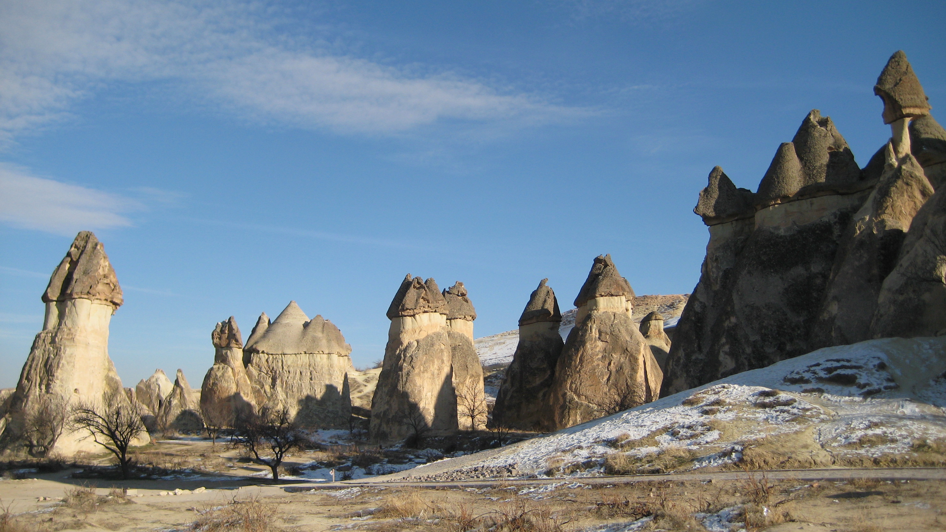
Göreme is a district of the Nevşehir Province in Turkey. After the eruption of Mount Erciyes about 2,000 years ago, ash and lava formed soft rocks in the Cappadocia Region, covering a region of about 20,000 km2. The softer rock was eroded by wind and water, leaving the hard cap rock on top of pillars, forming the present-day fairy chimneys. People of Göreme, at the heart of the Cappadocia Region, realized that these soft rocks could be easily carved out to form houses, churches, monasteries.
Goreme (Gorejące Góry, kurd.: Gore Me) to okręg w prowincji Nevszehir w obecnej Turcji. Dawniej ziemie te należały do Scytyjskiej Kąpodachji (kraj Dachów-Dahów, Chatów-Hettytów, Kumorów-Kimmerów [Kąpo-Morów], Draków-Traków i Bytyńców-Bitynów) zwanej przez Greków Kapadocją. Według podań, po erupcji sprzed 2000 lat pobliskiego wulkanu Erciyes ( starożytna nazwa grecka Argaeos, nazwa aryjska [sistańska, słowiano-indo-scytyjska]: Góra Arka Oś – Ośarka, Oś Arki, Ś-Arka) położonego w Górach Turów (Taurów), popiół i lawa uformowały skały o czarownych, kamiennych kształtach. Mieszkańcy Goreme – Gorejących Gór, owego serca Kąpodachji, przystosowali wnętrza tych skał do zamieszkania czyniąc z nich domy, kościoły, tłocznie oliwy, składy wina i inne obiekty użyteczne.
Dolinę Göreme odkrył dopiero w 1907 roku francuski duchowny Guillaume de Jerphanion (fr.). W dolinie znalazł blisko 350 kościołów wykutych w skale tufowej. Są to przede wszystkim małe, mieszczące kilkudziesięciu wiernych kościoły ze stropami kopułowymi. Kościoły w Göreme zdobione są freskami. Są to zarówno freski z okresu ikonoklazmu, jak również późniejsze, najstarsze pochodzą z IX wieku.
Góra Oś Arki, Ś-Arka, Arka-Oś Dag
Mount Erciyes (Turkish: Erciyes Dağı; derived from the ancient Greek name Ἀργαῖος Argaeos; Latinized as Argaeus by the ancient Romans) is a massive stratovolcano located 25 km to the south of Kayseri in Turkey.
Erciyes is the highest mountain in central Anatolia, located within the ancient region of Cappadocia, with its summit reaching 3,916 metres (12,848 ft). It is considered to be the highest peak of the Anti-Taurus mountain range, a northeastern extension of the Taurus Mountains to the south, and belongs to the Alpide belt in Eurasia.[3]
The volcano is heavily eroded, but may have erupted as recently as 253 BC, as may be depicted on Roman era coins.[4]
Wulkan (drag) jest mocno zwietrzały, pokryty rumowiskami, od dawna nieczynny. Możliwe jednak, że wybuchł w 253 roku p.n.e. i jest przedstawiony na monetach rzymskich. Na szczycie odkryto znaki pisma i starożytne symbole świadczące o tym że góra była odwiedzana w starożytności. Znajdują się tam także dwie groty, z których jedna jest poszerzona i przystosowana do zamieszkania rękami człowieka.
Strabo called the mountain Argaeus (Ἀργαῖος); he wrote that the summit was never free from snow and that those few who ascended it reported seeing both the Black Sea to the north and the Mediterranean Sea to the south in days with a clear sky.[5]
The first documented successful climb was performed by William John Hamilton in 1837. There are, however, some historic writings and symbols on the rocks at the summit, indicating earlier human presence there. There are two caves near the summit tower, of which at least one must have been expanded by humans. It is supposed that monks in historic times have visited the summit several times.
There are winter sports facilities on the mountain, usually accessed from nearby Kayseri.