Henges – Rondel enclosures
źródło Old European Culture © © tłumaczenie i komentarz Czesław Białczyński
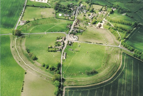
Stonehenge is a prehistoric monument in Wiltshire, England. One of the most famous sites in the world, Stonehenge is the remains of a ring of standing stones set within earthworks.
Archaeologists believe it was built from about 3000 BC to 2000 BC.
Stonehenge to prehistoryczny zabytek w Wiltshire w Anglii. Jednym z najbardziej znanych miejsc na świecie, Stonehenge jest pozostałość pierścienia stojących kamieni osadzonych w robotach ziemnych.
Archeolodzy uważają, że został zbudowany od około 3000 pne do 2000 pne
The original structure was a henge which is a circular bank and ditch enclosure, measuring about 110 metres (360 ft) in diameter, with a large entrance to the north east and a smaller one to the south. It has been dated to about 3100 BC.
Oryginalna konstrukcja była kręgiem, który jest kolistą obudową skarpy i rowu, mierzącą około 110 metrów średnicy, z dużym wejściem na północny wschód i mniejszym na południe. Jest datowany na około 3100 pne.
What most people don’t know is that over 1500 years earlier, the same types of henges were built in central Europe. There they are called rondel enclosures.
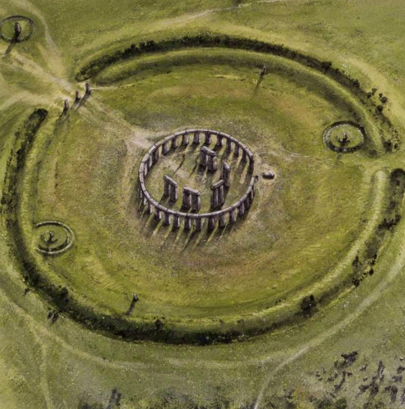
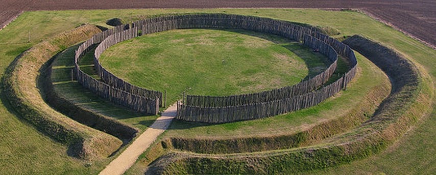
A number of approximately 120–150 Neolithic earthworks enclosures are known in Central Europe. They are called Kreisgrabenanlagen(„circular ditched enclosures”) in German, or alternatively as roundels (or „rondels”; German Rondelle; sometimes also „rondeloid”, since many are not even approximately circular). They are mostly confined to the Elbe and Danube basins, in modern-day Germany,Austria, Czech Republic, Slovakia, as well as the adjecent parts of Hungary and Poland, in a stretch of Central European land some 800 km (500 mi) across. They date to the first half of the 5th millennium BC; they are associated with the late Linear Pottery culture and its local successors, the Stroke-ornamented ware (Middle Danubian) and Lengyel (Moravian Painted Ware) cultures. The best known and oldest of these Circular Enclosures is the Goseck circle, constructed c. 4900 BC. The Goseck circle is a Neolithic structure in Goseck in the Burgenlandkreis district in Saxony-Anhalt, Germany. It is the oldest and best known of the so-called Circular Enclosures associated with the Central European Neolithic. It consists of a set of concentric ditches 75 metres (246 feet) across and two palisade rings containing gates in places aligned with sunrise and sunset on the solstice days. The Goseck ring is one of the best preserved and extensively investigated of the many similar structures built at around the same time.
Większość ludzi nie wie, że ponad 1500 lat wcześniej w Europie Środkowej zbudowano te same rodzaje kręgów obudowanych. Tu nazywane są obudowanymi Rondelami, lub rondelami.
W Europie Środkowej znanych jest około 120–150 neolitycznych obudów kręgów ziemnych. Nazywa się je Kreisgrabenanlagen („okrągłe porzucone budowle”) w języku niemieckim lub alternatywnie jako okrągłe (lub „rondele”; niemieckie Rondelle; czasami także „rondeloidalne”, ponieważ wiele z nich nie jest nawet w przybliżeniu okrągłych). Są one głównie ograniczone do basenów Łaby i Dunaju we współczesnych Niemczech, Austrii, Czechach, na Słowacji, a także w sąsiednich częściach Węgier i Polski, na odcinku Europy Środkowej o długości około 800 km (500 mil) . Pochodzą z pierwszej połowy 5. tysiąclecia p.n.e.; są one związane z późną kulturą ceramiki wstęgowej i jej lokalnymi następcami, kulturami ceramiki kłutej (środkowy naddunajski) i kulturami Lengyel (morawskiej ceramiki malowanej). Najbardziej znanym i najstarszym z tych okrągłych budowli jest ta koło Gosiecka, zbudowana ok. 4900 p.n.e.. Krąg z Gosiecka jest strukturą neolityczną w Gosiecku w powiecie Burgenlandkreis w Saksonii-Anhalt w Niemczech. Jest to najstarsza i najbardziej znana z tak zwanych obudowanych kręgów związanych z neolitem środkowoeuropejskim. Składa się z zestawu koncentrycznych rowów o szerokości 75 metrów (246 stóp) i dwóch pierścieni palisadowych zawierających bramy w miejscach wyrównanych do wschodu i zachodu słońca w dniu przesilenia. Rondel w Gosiecku jest jedną z najlepiej zachowanych i szeroko badanych spośród wielu podobnych konstrukcji zbudowanych mniej więcej w tym samym czasie.
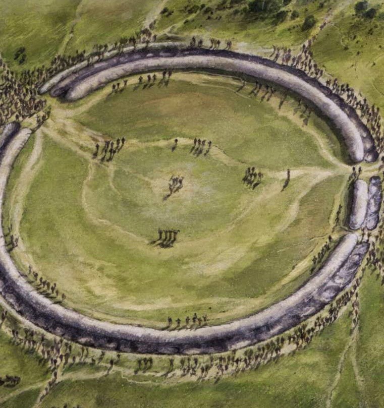
Traces of the original configuration reveal that the Goseck ring consisted of four concentric circles, a mound, a ditch, and two wooden palisades. The palisades had three sets of gates facing southeast, southwest, and north. At the winter solstice, observers at the center would have seen the sun rise and set through the southeast and southwest gates.
Archaeologists generally agree that Goseck circle was used for observation of the course of the Sun in the course of the solar year. Together with calendar calculations, it allowed coordinating an easily judged lunar calendar with the more demanding measurements of a solar calendar.
The Goseck circle is the oldest known structure with this type of astronomical alignment.
Ślady oryginalnej konfiguracji wskazują, że pierścień Gosiecka składał się z czterech koncentrycznych kół, kopca, rowu i dwóch drewnianych palisad. Palisady miały trzy zestawy bram skierowane na południowy wschód, południowy zachód i północ. Podczas przesilenia zimowego obserwatorzy w centrum widzieliby wschodzące słońce i przechodzące przez południowo-wschodnią i południowo-zachodnią bramę.
Archeolodzy ogólnie zgadzają się, że krąg z Gosiecka był używany do obserwacji przebiegu Słońca w ciągu roku słonecznego. Wraz z obliczeniami kalendarza pozwoliło to na koordynację łatwo obserwowanego kalendarza księżycowego z bardziej wymagającymi pomiarami kalendarza słonecznego.
Krąg Gosecka jest najstarszą znaną strukturą z tego rodzaju astronomicznym ustawieniem.
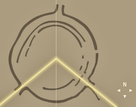
Here is the map of alignments of the Goseck circle:
Oto mapa osi kręgu Gosiecka:
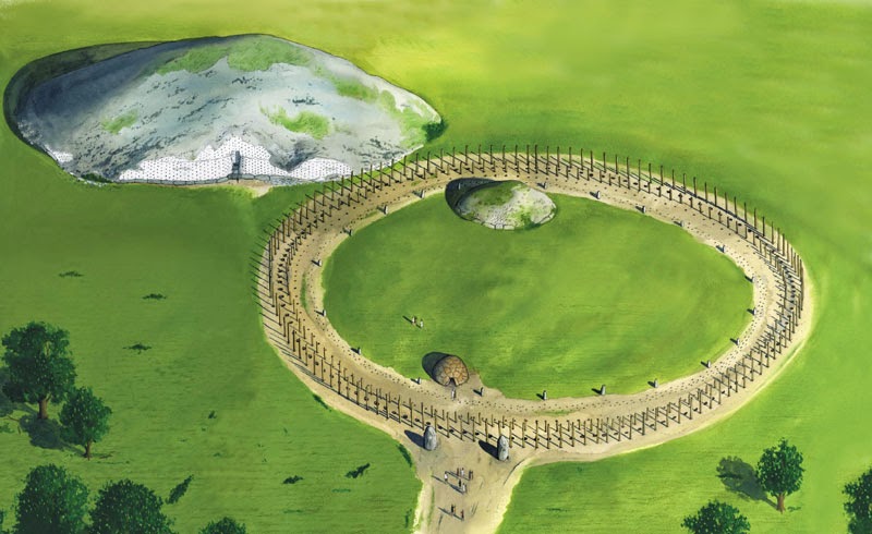
And here is the reconstruction of the Goseck circle:
A oto rekonstrukcja kręgu z Gosiecka:
This is another Central European Henge, Rondel enclosure. This one is from Bučany, Slovakia. Does it remind you of anything? Celtic cross maybe?
To kolejna budowla rondelowa z Europy Środkowej, Rondel. Ten jest z Bučan na Słowacji. Czy coś ci to przypomina? Może celtycki krzyż?
These are different types of Central European rondel enclosures:
Są to różne typy obudów rondelów w Europie Środkowej:
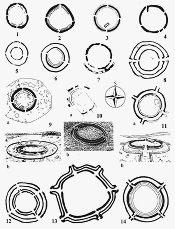
Principal types of the Neolithic-Rondels in central Danubian region: (1) Němčičky, Moravia. (2) Vedrovice, Moravia. (3) Nitrianský Hrádok, Slovakia. (4) Rašovice, Moravia. (5) Kľačany, Slovakia. (6) Strögen, Lower Austria. (7) Běhařovice, Moravia. (8 ) Hornsburg 3, Lower Austria. (9) Těšetice-Kyjovice, Moravia. (10) Rosenburg, Lower Austria. (11) Bučany, Slovakia. (12) Cífer, Slovakia. (13) Golianovo, Slovakia. (14) Svodín, Slovakia.
In 2009 Czech archaeologists have uncovered four prehistoric rondel enclosures (a type of circular prehistoric earthworks enclosure), two of which are the largest in Europe.
After examining 40 hectares on land, the experts gathered hundreds of thousands of finds. The most important ones include the four rondel enclosures.
Two of the enclosures that archaeologists have uncovered near Kolin are 214 and 230 meters in diameter and have been dated to first half of the 5th millennium bc. The former was surrounded by four ditches, the biggest being 4.5m deep and 14m long. The other two enclosures uncovered near Kolin are 80 and 75 meters in diameter. Besides Neolithic finds, the experts uncovered a number of valuable remains of settlements from the Paleolithic period, from the Bronze and Iron Ages, from the Roman era and the early Middle Ages. This means that the area has been an important settlement and probably important ceremonial center for at least 5000 years. This is another example of potential cultural continuity in central Europe from neolithic to medieval time.
Until recently, researchers thought that there are no henges in Poland. Henges were mostly found a little further south, where Neolithic farming flourished: in Germany, Austria, Hungary, Slovakia and the Czech Republic.
In the mid 1990s, aerial reconnaissance led by Otto Braasch and Gunter Wetzel revealed the existence of rondel-type sites in central Germany, along the mid Elbe–Saale corridor and perhaps extending as far north as the lower Odra Valley. Even though the Neolithic dates of the most northern central German rondels have since been called into question, this discovery led to a significant northern extension of the known distribution of this monument type, making it very likely that rondels would also appear in the northern fringe of Danubian Neolithic distributions in Poland. The chance to verify this theory came during a training course for aerial archaeologists held near Leszno, Poland, in the summer of 1998. Braasch found the first rondel in Poland on the border between Lower Silesia and the Lebus Land. It lies on the northern slopes of the Dalkowskie Hills near the town of Bytom Odrzafiski in the fields of the village of Bodzow. Further indications of the presence of putative early fifth-millennium rondel-type enclosures in Poland came in the year 2008, when aerial archaeological prospection revealed a circular, double-ditched enclosure with characteristic interconnected entrances at Wenecja on a hilltop on the eastern shore of Lake Biskupin in Kuiavia. By studying images available in Google Earth, a double-ditched and palisaded enclosure was discovered at Pietrowice Wielkie in 2011, a site which has produced Neolithic surface finds. The latest archaeological data from the site is suggesting that the site could have been used as forth during the early bronze age Pre Lusitanian period, and that it could even have originally been built as an early bronze age fort. We know that many sites have been used for very long period of time and that during that time the use of the site sometimes changed. So it is possible that the bronze age fort was built on much earlier neolithic site.
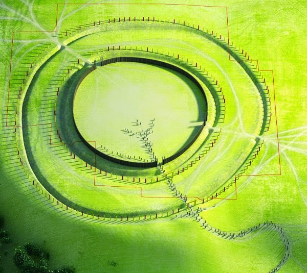
This is a reconstruction of the rondel (henge) or fort in Pietrowice Wielkie:
W 2009 r. Czescy archeolodzy odkryli cztery prehistoryczne obudowane rondele (rodzaj okrągłej prehistorycznej budowli ziemnej), z których dwie są największe w Europie.
Po zbadaniu 40 hektarów na lądzie eksperci zgromadzili setki tysięcy znalezisk. Najważniejsze z nich obejmują cztery obudowane Rondele.
Dwa z odkrytych przez archeologów w pobliżu Kolina, mają średnicę 214 i 230 metrów i zostały wydatowane na pierwszą połowę 5 tysiąclecia p.n.e.. Pierwszy był otoczony czterema rowami, z których największy miał 4,5 m głębokości i 14 m długości. Pozostałe dwa kręgi odkryte w pobliżu Kolina mają średnicę 80 i 75 metrów. Oprócz znalezisk neolitycznych eksperci odkryli wiele cennych pozostałości osad z okresu paleolitu, z epoki brązu i żelaza, z czasów rzymskich i wczesnego średniowiecza. Oznacza to, że obszar ten był ważną osadą i prawdopodobnie ważnym centrum ceremonialnym przez co najmniej 5000 lat. To kolejny przykład potencjalnej ciągłości kulturowej w Europie Środkowej od neolitu do średniowiecza.
Do niedawna badacze uważali, że w Polsce nie ma żadnych rondelów. Kręgi znaleziono głównie nieco dalej na południe, gdzie kwitło rolnictwo neolityczne: w Niemczech, Austrii, na Węgrzech, na Słowacji i w Czechach.
W połowie lat 90. zwiad powietrzny prowadzony przez Otto Braascha i Guntera Wetzela ujawnił istnienie stanowisk typu rondel w środkowych Niemczech, wzdłuż środkowego korytarza Łaba – Saale i być może rozciągających się daleko na północ aż do doliny dolnej Odry. Chociaż od tego czasu kwestionowano neolityczne daty najbardziej północnych rondeli środkowo-niemieckich, odkrycie to doprowadziło do znacznego rozszerzenia północnego znanego rozmieszczenia tego typu zabytków. Jest bardzo prawdopodobne, że rondele pojawią się również na północnych krańcach kultur neolitycznych naddunajskich w Polsce. Szansa na zweryfikowanie tej teorii pojawiła się podczas szkolenia dla archeologów lotniczych, które odbyło się pod Lesznem w Polsce latem 1998 roku. Braasch znalazł pierwszy w Polsce rondel na granicy Dolnego Śląska z Ziemią Lubuską. Leży na północnych zboczach Wzgórz Dalkowskich w pobliżu miejscowości Bytom Odrzański na polach wsi Bodzów. Dalsze oznaki obecności domniemanych budowli rondelowych z początków piątego tysiąclecia w Polsce pojawiły się w 2008 roku, kiedy z badań archeologicznych z powietrza wynikało, że w Wenecji na szczycie wzgórza na wschodnim brzegu jeziora znajduje się okrągła, podwójnie wykopana obudowa z charakterystycznymi połączonymi wejściami jak Biskupin na Kujawach. Badając obrazy dostępne w Google Earth, w 2011 r. W Pietrowicach Wielkich odkryto podwójnie wykopaną i palisadowaną obudowę, w której znaleziono neolityczne znaleziska powierzchniowe. Najnowsze dane archeologiczne z tego miejsca sugerują, że miejsce to mogło być wykorzystane jako czwarte we wczesnej epoce brązu w okresie przedłużyckim i że mogło być nawet pierwotnie zbudowane jako fort we wczesnej epoce brązu. Wiemy, że wiele kręgów było używanych przez bardzo długi czas i że w tym czasie sposób korzystania z obserwatorium czasami się zmieniał. Możliwe więc, że fort z epoki brązu został zbudowany na znacznie wcześniejszym neolitycznym stanowisku.
To jest rekonstrukcja rondela (kręgu) lub fortu w Pietrowicach Wielkich:
The distribution of rondel (henge) structures seems to suggest a spread from the middle Danube (southern Slovakia and western Hungary) towards the west (Lower Austria, Lower Bavaria) along the Danube and to the northwest (Moravia, Bohemia, Saxony-Anhalt) following the Elbe.
They precede the comparable circular earthwork or timber enclosures known from Great Britain and Ireland, constructed much later during c. 3000 to 1000 BC (late Neolithic to Bronze Age).
Henges, rondel enclosures originate in the middle Danube area and Morava area. From there they have spread northward towards south Baltic finally reaching Saxony and Pomeranija. This means that the culture that built these megalithic structures came from Central Europe and reached the British Isles via south Baltic, and specifically Elbe region, Pomerania, Pomorje, the land of Fomori.
Some of the finest and best-known English henges are at:
Avebury, about 20 miles (32 km) N. of Stonehenge on Salisbury Plain in Wiltshire;
Rozmieszczenie struktur rondelowych (kręgów) wydaje się sugerować rozprzestrzenienie się od środkowego Dunaju (południowa Słowacja i zachodnie Węgry) w kierunku zachodnim (Dolna Austria, Dolna Bawaria) wzdłuż Dunaju i na północny zachód (Morawy, Czechy, Saksonia-Anhalt) podążając za Łabą.
Poprzedzają one porównywalne okoiliste obudowy budowli ziemnych lub drewnianych znane z Wielkiej Brytanii i Irlandii, zbudowane znacznie później w okresie ok. 3000 do 1000 p.n.e. (od późnego neolitu do epoki brązu).
Kręgi, rondele obudowane pochodzą ze środkowego obszaru Dunaju i obszaru Morawy. Stamtąd rozprzestrzeniły się na północ w kierunku południowego Bałtyku, docierając w końcu do Saksonii i Pomorza. Oznacza to, że kultura, która zbudowała te budowle megalityczne, pochodziła z Europy Środkowej i docierała do Wysp Brytyjskich przez południowy Bałtyk, a zwłaszcza do regionu Łaby, Pomorza, Pomorja, ziemi Fomori.
Niektóre z najlepszych i najbardziej znanych angielskich kręgów są w:
Avebury, około 32 km na północ od Stonehenge na równinie Salisbury w hrabstwie Wiltshire;
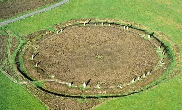
The Ring of Brodgar in Orkney;
Knowlton Circles henge complex in Dorset;
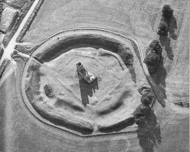
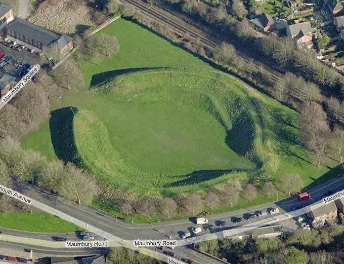
- Maumbury Rings in Dorset.
Thornborough Henges complex in Yorkshire;
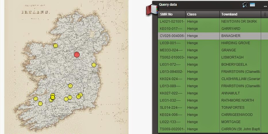
This is a list of all the Irish henges as recorded in the National monument service database:
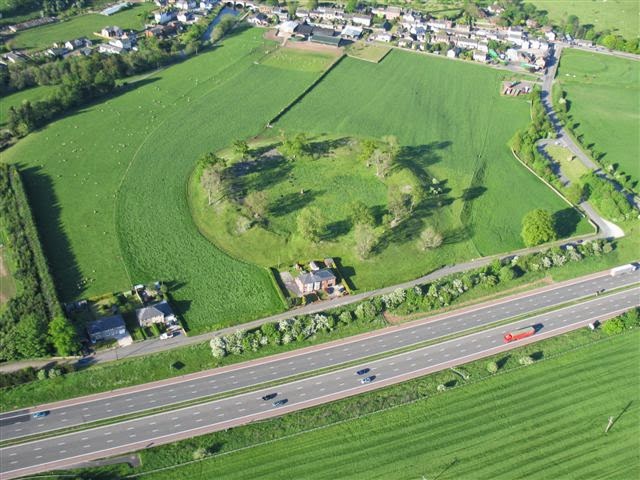
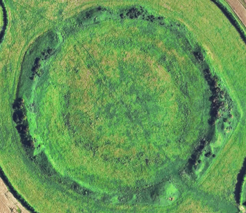
And here is another example from Ireland, the so called Woodhenge:
A oto kolejny przykład z Irlandii, tak zwany Woodhenge:
Ireland’s Stonehenge, a 4,500-year-old structure at the Hill of Tara in Co Meath, has been re-created by archaeologists and computer-graphics experts. Underground remains of the structure were discovered by soil x-rays of the hill. Study of the remains of tree trunks have prompted scientists to conclude the hill was once surrounded by a “wooden version of Stonehenge” that would have been 250 metres in diameter.
Archaeologists believe elaborately decorated timber posts and crossbars rose out of the ditch and surrounded the tomb, which is believed to be Tara’s oldest monument. It is estimated the mound was raised in about 3,000BC, making it a contemporary of Stonehenge, the ancient monument in the English county of Wiltshire. Rondel enclosure, henge structures are mostly interpreted as having served a cultic purpose. Most of them are aligned and seem to have served the function of a calendar (”Kalenderbau”), in the context of archaeoastronomy sometimes dubbed „observatory”, with openings aligned with the points sunrise and/or sunset at the solstices. This is the case with the „gates” or openings of the roundels of Quenstedt, Goseck and Quedlinburg as well as in Stonehenge. The observational determination of the time of solstice would have served a practical (agricultural) purpose. It could have been used to maintain a lunisolar calendar. The accurate knowledge of the date of solstice allows an accurate handling of intercalary months and determining the the correct date for agricultural activities such as plowing, sawing and harvesting.
At the end I would like to ask one question:
Archeolodzy uważają, że bogato zdobione drewniane słupy i poprzeczki wyszły z rowu i otoczyły grobowiec, który uważa się za najstarszy zabytek Tary. Szacuje się, że kopiec został wzniesiony około 3 000 lat p.n.e., co czyni go współczesnym Stonehenge, starożytnym zabytkiem w angielskim hrabstwie Wiltshire. W obudowanych Rondelach, konstrukcje kręgu są w większości interpretowane jako służące kultowi. Większość z nich jest wyrównana i wydaje się, że pełniła funkcję kalendarza („Kalenderbau”), w kontekście archeoastronomii nazywanego czasami „obserwatorium”, z otworami zrównanymi z punktami wschodu i / lub zachodu słońca podczas przesilenia. Tak jest w przypadku „bram” lub otworów w rundach Quenstedt, Goseck i Quedlinburg, a także w Stonehenge. Obserwacyjne określenie czasu przesilenia służyłoby celowi praktycznemu (rolnemu). Mógł zostać wykorzystany do otrzymania kalendarza księżycowo-słonecznego. Dokładna znajomość daty przesilenia pozwala na dokładną obsługę miesięcy przestępnych i określenie prawidłowej daty dla działań rolniczych, takich jak orka, koszenie i zbiór.
Na koniec chciałbym zadać jedno pytanie:
When you read about central European rondel enclosures, you are always told that
But, by contrast to the long lifetime of the „Megalithic” culture, the time window during which the neolithic ”Roundels” were in use is surprisingly narrow, lasting only for about 200–300 years (roughly 49th to 47th centuries BC). How is this usage period determined? Once the henge is built and aligned, further usage of the henge will leave no traces. To determine the day of the solstice all you need is to stand in the center or in any other predetermined cardinal point of the henge every morning and evening and note where the sun is rising and setting. Thus the henges could have been used as solar observatories thousands of years after they were built without any trace of usage being left behind. Is it possible that rondel enclosures continued to be used long after they were built?
This statement from the document about Polish rondels: „Even though the Neolithic dates of the most northern central German rondels have since been called into question” is very important. It would suggest that further up north you go, the younger the rondels (henges) become. This could mean that the spread of rondels fallowed spread of agriculture from the south of Europe to the Baltic and then across the sea to Britain and Ireland. I would suggest that there could be a rondel waiting to be found dating from the period between 4500 bc and 3000 bc somewhere in Ireland probably in the same area where we find old field boundaries from the earliest agricultural period. Maybe it has already been discovered, but it has been misdated because it was used continually for a long time…
I will talk about the usage of henges and the link between the henges and the early agriculture in one of my next posts. Until then have fun and stay happy and healthy. And if you liked what you have just read, please leave a comment or google + the post.
Kiedy czytasz o środkowoeuropejskich obudowanych rondelach, zawsze ci to mówią:
„Jednak w przeciwieństwie do długiej żywotności kultury „megalitycznej”, okno czasowe, w którym neolityczne „Rondele” były w użyciu, jest zaskakująco wąskie i trwa tylko około 200–300 lat (około 49 do 47 wieku pne)” . Jak określa się ten okres użytkowania? Gdy krąg zostanie zbudowany i wyrównany, dalsze korzystanie z niego nie pozostawi żadnych śladów. Aby określić dzień przesilenia, wszystko, czego potrzebujesz, to stać każdego dnia rano i wieczorem w centrum lub w innym wyznaczonym kardynalnym punkcie kręgu i zanotować, gdzie wschodzi i zachodzi słońce. Tak więc kręgi mogły być wykorzystane jako obserwatoria słoneczne tysiące lat po ich budowie bez pozostawienia śladu użytkowania. Czy to możliwe, że obudowane Rondele były używane długo po ich zbudowaniu?
Bardzo ważne jest stwierdzenie z dokumentu o polskich rondelach: „Mimo że neolityczne daty najbardziej północnych rondli środkowo-niemieckich zostały już zakwestionowane” – to jest bardzo ważne. Sugerowałoby to, że im dalej na północ, tym młodsze rondele (kręgi). Może to oznaczać, że rozprzestrzenianie się rondeli rozpoczęło się z kultur rolniczych z południa Europy nad Bałtyk, a następnie przez morze do Wielkiej Brytanii i Irlandii. Sugerowałbym, że może istnieć rondel z okresu od 4500 p.n.e. do 3000 p.n.e. gdzieś w Irlandii, prawdopodobnie na tym samym obszarze, na którym znajdują się stare granice pól z najwcześniejszego okresu rolniczego. Być może został już odkryty, ale został zniekształcony, ponieważ był używany przez długi czas …
Opowiem o użyciu kręgów i związku między kręgami a wczesnym rolnictwem w jednym z moich kolejnych postów. Do tego czasu baw się dobrze i bądź szczęśliwy i zdrowy. A jeśli podobało Ci się to, co właśnie przeczytałeś, zostaw komentarz lub google + post.