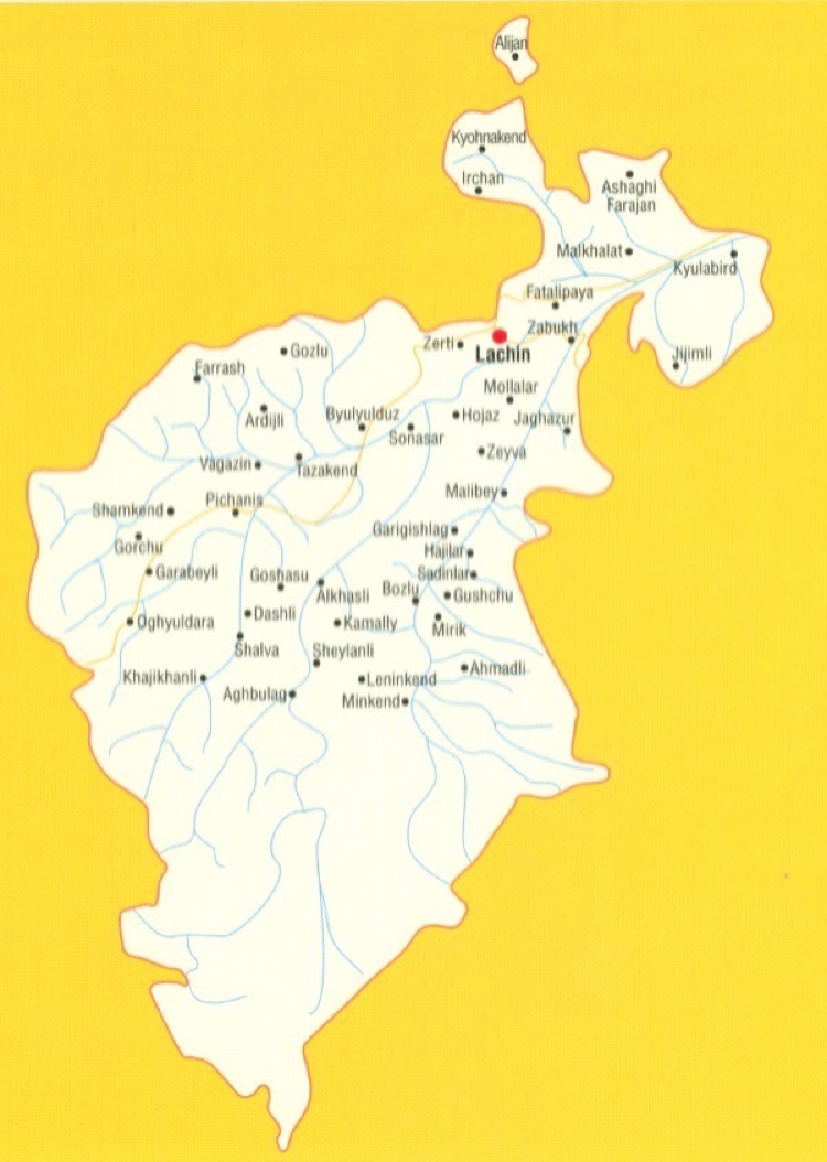
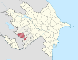
The region of Lachin is the administrative region of the Republic of Azerbaijan. It is located in the south-western part of the Minor Caucasus. It neighbors with the Republic of Armenia in the west. Its area is 1840 km2; the population is 70,900 (01.01.2011). The central town is the city of Lachin. The region’s territory has been under the Armenian occupation since May 18,1992.
Region Lachin jest regionem administracyjnym Republiki Azerbejdżanu. Znajduje się w południowo-zachodniej części Małego Kaukazu. Sąsiaduje z Republiką Armenii na zachodzie. Jego powierzchnia to 1840 km2; populacja wynosi 70,900 (01.01.2011). Centralnym miastem jest miasto Lachin. Terytorium regionu znajduje się pod okupacją ormiańską od 18 maja 1992 r.
The region covers the following districts and villages: city of Lachin; district of Gayghi and villages оf Agbulag; Alkhasly; Ahmadli; Hajilar; Gulabird; Jagazur; Gushchu; Minkend; Mirik; Mishni; Sadynlar; Sheylanly Agjakend; Ardushlu; Agjayazy; Ashaghi Farajan; Farajan; Bozlu; Galaja; Bulunduz; Ayibazar; Birinji Ipek; Vagazin; Bozguney; Kalafalyg; Hajikhanly; Govushug; Budagdere; Hojaz; Mollalar; Uluduz; Avazlar; Dashly; Valibayli; Naryshlar; Hetemler; Kaha; Jijimli; Ashaghi Jijimli; Gazydere; Zabukh; Sus; Ghyzylja; Baylik; Irchan; Chambarakhach; Khumarta; Garabayli; Lolabaghirli; Korchabulag; Zerti; Khyrmanlar; Agbulag; Birinji Tyghyk; Ikinji Tyghyk; Garygyshlag; Soyugbulag; Ghylychly; Zeyve; Kohnekend; Gyshlag; Eyrek; Alyjan; Gozlu; Finghe; Gorchu; Zagalty; Goshasu; Alpout; Butovluk; Kurdhaji; Arikli; Hajisamly; Garasaggal; Kamally, Chyragly; Garakechdi; Katos; Malkhalaf; Mazutlu; Malikpeye; Malybay; Agoglan; Husulu; Ziyrik; Myghydere; Dayirmanyany; Tarkhanly; Dayhan; Baldyrganly; Oguldere; Agalarushaghy; Pirjahan; Seyidler; Garachanly; Pichenis; Khachynaly; Kohne Jorman; Sonasar; Mayis; Tezekend; Hagnezer; Erdeshevi; Safiyan; Khanalylar; Suarasy; Turkler; Farrash; Nureddin; Fatalipeye; Aganus; Unannovlu; Arab; Turshsu; Shelve; Imanlar; Dambulag; Shamkend; Elekchi; Bozdogan; Chorman; Nagdaly.
The following educational and social institutions were providing its services before the occupation: 101 secondary schools; 2 pre-school and 5 out-school educational institutions; 1 vocational school; 85 clubs, 119 libraries; 5 musical schools; 142 healthcare institutions. The region had also the architectural monuments such as the Albanian temple (V century), turbehs (XIV, XIX centuries), the fortress (XVII century), the mosque (1718), the palace (1716), the bridge (XVIII century) and others.
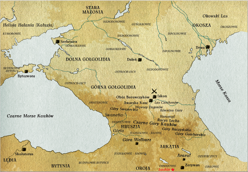
Na mapie z Królestwa SIS (Tomirysa i Czaropanowie – Światynia Dziewieciu Kręgów) Lachin znajduje się dokładfnie w zaznaczonym czerwona gwiazdka miejscu. Zwracam jednak waszą uwagę na pasmo górskie powyżej, w czarnych Górach Kauków (Kaukazie) pomiędzy Górami Gpmborskimi a Haramądem, które nazywa się Racza Lecha lub Lachska Racz.
Region obejmuje następujące dzielnice i wsie: miasto Lachin; okręg Gayghi i wsie Agbulag; Alkhlyly; Ahmadli; Hajilar; Gulabird; Jagazur; Gushchu; Minkend; Mirik; Mishni; Sadynlar; Sheylanly Agjakend; Ardushlu; Agjayazy; Ashaghi Farajan; Farajan; Bozlu; Galaja; Bulunduz; Ayibazar; Birinji Ipek; Vagazin; Bozguney; Kalafalyg; Hajikhanly; Govushug; Budagdere; Hojaz; Mollalar; Uluduz; Avazlar; Dashly; Valibayli; Naryshlar; Hetemler; Kaha; Jijimli; Ashaghi Jijimli; Gazydere; Zabukh; Sus; Ghyzylja; Baylik; Irchan; Chambarakhach; Khumarta; Garabayli; Lolabaghirli; Korchabulag; Zerti; Khyrmanlar; Agbulag; Birinji Tyghyk; Ikinji Tyghyk; Garygyshlag; Soyugbulag; Ghylychly; Zeyve; Kohnekend; Gyshlag; Eyrek; Alyjan; Gozlu; Finghe; Gorchu; Zagalty; Goshasu; Alpout; Butovluk; Kurdhaji; Arikli; Hajisamly; Garasaggal; Kamally, Chyragly; Garakechdi; Katos; Malkhalaf; Mazutlu; Malikpeye; Malybay; Agoglan; Husulu; Ziyrik; Myghydere; Dayirmanyany; Tarkhanly; Dayhan; Baldyrganly; Oguldere; Agalarushaghy; Pirjahan; Seyidler; Garachanly; Pichenis; Khachynaly; Kohne Jorman; Sonasar; Mayis; Tezekend; Hagnezer; Erdeshevi; Safiyan; Khanalylar; Suarasy; Türkler; Farrash; Nureddin; Fatalipeye; Aganus; Unannovlu; Arab; Turshsu; Odłożyć na półkę; Imanlar; Dambulag; Shamkend; Elekchi; Bozdogan; Chorman; Nagdaly.
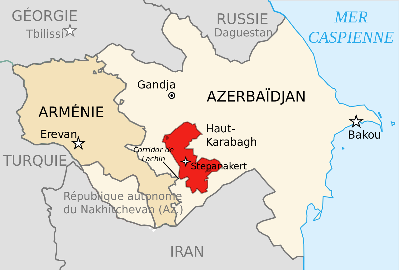
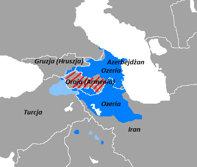
Korytarz Lachin (ormiański: Լաչինի միջանցք Lachini mijantsk) jest przełęczą graniczną de jure w Azerbejdżanie, stanowiącą najkrótszą drogę między Armenią a Republiką Artsakh. Podczas wojny o Nagorno-Karabach znalazł się pod kontrolą Republiki Górskiego Karabachu, chociaż oficjalnie należy do lazińskiego jedwabiu Azerbejdżanu.
W oświadczeniu dla Organizacji Narodów Zjednoczonych z 18 września 2005 r. Minister spraw zagranicznych Azerbejdżanu Elmar Mammadyarov powiedział: „Jest to kwestia komunikacji Ormian żyjących w Azerbejdżanie z Armenią Górnego Karabachu i Azerbejdżanu mieszkających w region Nakhchivan w Azerbejdżanie wraz z resztą kraju Sugerujemy wykorzystanie tak zwanego korytarza Lachin – który powinien być nazwany „Drogą Pokoju” – obustronnie w obu kierunkach, pod warunkiem, że bezpieczeństwo tej drogi zapewnią wielonarodowe siły pokojowe na początkowym etapie początkowym.
Następujące instytucje edukacyjne i społeczne świadczyły tam swoje usługi przed okupacją: 101 szkół średnich; 2 przedszkolne i 5 pozaszkolnych placówek edukacyjnych; 1 szkoła zawodowa; 85 klubów, 119 bibliotek; 5 szkół muzycznych; 142 instytucje opieki zdrowotnej. W regionie znajdowały się również zabytki architektoniczne, takie jak świątynia albańska (V wiek), turby (XIV, XIX wiek), twierdza (XVII wiek), meczet (1718), pałac (1716), most (XVIII wiek) i inni.
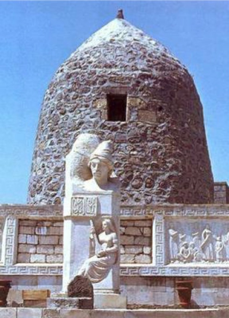
Aghoghlan Temple
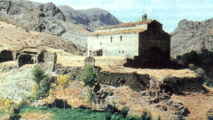
Aghoghlan temple is set in two acres of land at the 30th kilometer of Lachin-Minkend highway, on the right bank of the river Hekeri, near Kosalar village. Aghoghlan Temple is Albanian monastery built in the 5th-6th centuries. As the monument was exposed to avalanches and destructions at different times, it was rebuilt in the style of church and adapted to monastery. The first foundation of the monument was preserved in its initial form during repairs; the new walls were built over the old ones. After restoration, Aghoghlan temple had become one of the most spectacular monuments of the Albanian period architecture of the Azerbaijani history. The temple is 25 meters long and 12.5 meters wide. Two rows of the square-shaped eight bearing piles – pylons divided the inner side of the building into three parts.
The monument has been under occupation since May 18, 1992. Armenians made illegal changes in architectural style and the interior of Aghoghlan monastery, completely wiped out the inscriptions on the walls of the monument, as well as a large number of ornaments and symbols reflecting the Albanian period or greatly changed them. In 2006, under the pretext of repairing the monument for the second time, the Armenians placed in different parts of the walls 26 boards with inscriptions indicating belongingness of the monument to the Armenian Apostolic Church. 2 tombstones were erected in the right side of the courtyard and 2 stone crosses made of red basalt stone from Irevan were erected in front of the entrance door by Armenians.
After the occupation the Armenians renamed the Aghoghlan temple “Jijernavank”.
Świątynia Aghoghlan
Świątynia Aghoghlan położona jest na dwóch akrach ziemi na 30-tym kilometrze autostrady Lachin-Minkend, na prawym brzegu rzeki Hekeri, w pobliżu wioski Kosalar. Świątynia Aghoghlan to albański klasztor zbudowany w V-VI wieku. Ponieważ pomnik był narażony na lawiny i zniszczenia w różnym czasie, został przebudowany w stylu kościoła i przystosowany do klasztoru. Pierwsze fundamenty pomnika zachowały się w pierwotnej formie podczas remontów; nowe mury zostały zbudowane nad starymi. Po restauracji świątynia Aghoghlan stała się jednym z najbardziej spektakularnych zabytków architektury okresu albańskiego w historii Azerbejdżanu. Świątynia ma 25 metrów długości i 12,5 metra szerokości. Dwa rzędy o kształcie kwadratu ośmiu stosów łożyskowych – pylony podzieliły wewnętrzną stronę budynku na trzy części.
Pomnik znajduje się pod okupacją od 18 maja 1992 roku. Ormianie dokonali nielegalnych zmian w stylu architektonicznym i wnętrzu klasztoru Aghoghlan, całkowicie wymazali napisy na ścianach pomnika, a także dużą liczbę ozdób i symboli odzwierciedlających Okres albański lub znacznie je zmienił. W 2006 roku, pod pretekstem naprawy pomnika po raz drugi, Ormianie umieścili w różnych częściach murów 26 tablic z inskrypcjami wskazującymi na przynależność pomnika do Ormiańskiego Kościoła Apostolskiego. W prawej części dziedzińca wzniesiono 2 nagrobki, a Ormianie postawili przed drzwiami wejściowymi 2 kamienne krzyże z czerwonego kamienia bazaltowego z Irevan.
Po okupacji Ormianie przemianowali świątynię Aghoghlan „Jijernavank”.
Hamza Soltan Palace
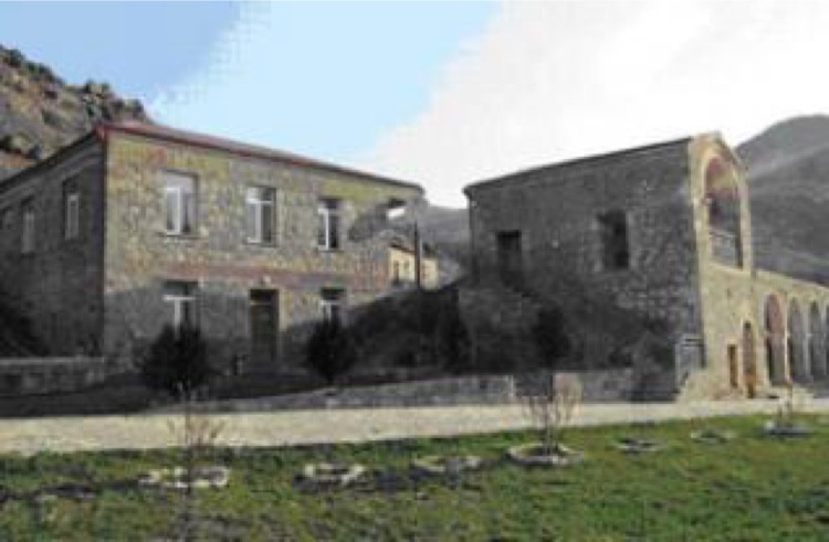
The palace is situated in Husulu village of Lachin region. The Hamza Soltan Palace is supposed to be built in 1761. From the general view of the palace it becomes clear that, the castle had a tall tower. There was an entrance door in the corner of the south side of the castle. The two-storeyed palace has beautiful arched ceilings fastened to the thick side walls. The palace also has a large hall, a number of auxiliary rooms and a court-house. Delicately embellished door and windows of the palace are made of the walnut wood. Eastern architectural traditions were widely used in the building of the palace. Most probably the sultanate was established here in 1700 and governed a large part of Zangezur region. The palace building was constructed of local stone and construction lime. After the occupation by Armenia, the village was renamed Melikatun. At the present time, the Armenian invaders make use of the repaired Hamza Soltan Palace as a guest house or a hotel for tourists.
Pałac Hamza Soltan
Pałac znajduje się w wiosce Husulu w regionie Lachin. Pałac Hamza Soltan ma być zbudowany w 1761 roku. Z ogólnego widoku pałacu staje się jasne, że zamek miał wysoką wieżę. W kącie południowej części zamku znajdowały się drzwi wejściowe. Dwupiętrowy pałac ma piękne sklepione sufity przymocowane do grubych ścian bocznych. Pałac ma również dużą salę, szereg pomieszczeń pomocniczych i dwór. Delikatnie zdobione drzwi i okna pałacu wykonane są z drewna orzechowego. Wschodnie tradycje architektoniczne były szeroko stosowane w budownictwie pałacu. Najprawdopodobniej sułtanat powstał tutaj w 1700 roku i rządził dużą częścią regionu Zangezur. Budynek pałacu został zbudowany z lokalnego kamienia i wapna budowlanego. Po okupacji przez Armenię miejscowość została przemianowana na Melikatun. W chwili obecnej najeźdźcy ormiańscy korzystają z naprawionego pałacu Hamza Soltan jako pensjonatu lub hotelu dla turystów.
Jijimli Village Tombs
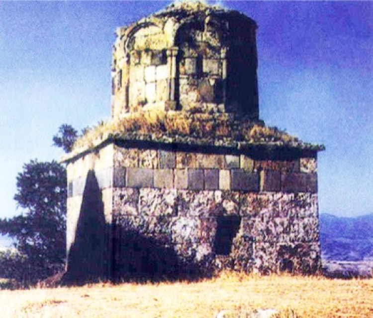
Two tombs rise close within a shrine near Jijimli village. Malik Ajdar Tomb, traditionally considered the oldest one, is circular inside and octagonal outside.
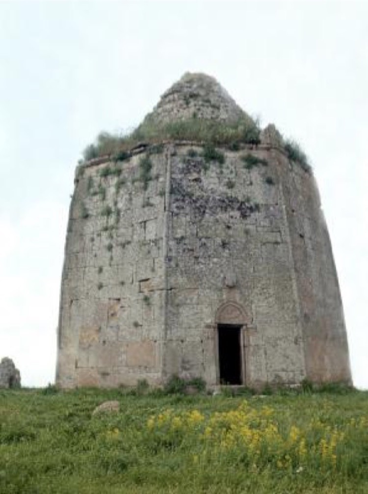
The right-angle opening of the tomb, the front door is in the northern side. The top of the door frame is covered with a pointed-beam-like architrave stone. Inside its edge, remains of a rider’s hewn picture are observed. A number of the site’s details are the same as those of tombs in Damirchilar village of Gubadli region. There are no construction inscriptions and carved surfaces on the tombs. The researchers supposedly date the Jijimli tomb from the 12th-13th centuries. The late 13th century, in the reign of Elkhanids, seems more convincing as the construction time.
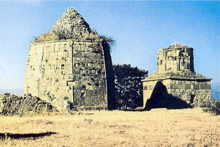
Popularly called the “Deaf Dome”, the other Jijimli tomb is cruciform inside and square outside. It is supposed to have been constructed in the 17th century.
Both of monuments are presently under the occupation of the Armenian Armed Forces.
Grobowce wsi Jijimli
Dwa grobowce wznoszą się blisko świątyni niedaleko wioski Jijimli. Grób Malika Ajdara, tradycyjnie uważany za najstarszy, jest okrągły wewnątrz i ośmiokątny na zewnątrz.
Otwarcie grobu pod kątem prostym, drzwi wejściowe znajdują się po stronie północnej. Górna część ościeżnicy jest pokryta ostrym jak belka kamieniem ościeżnicy. W jego skraju widoczne są resztki ociosanego obrazu jeźdźca. Wiele szczegółów tej strony jest takich samych, jak w grobowcach w wiosce Damirchilar w regionie Gubadli. Na grobowcach nie ma inskrypcji budowlanych i rzeźbionych powierzchni. Naukowcy ponoć datują grobowiec Jijimli z XII-XIII wieku. Pod koniec XIII wieku, za panowania Elchanidów, wydaje się bardziej przekonujący czas budowy.
Powszechnie nazywany „Głuchą Kopułą”, drugi grobowiec Jijimli ma kształt krzyża wewnątrz i na zewnątrz. Miało powstać w XVII wieku.
Oba zabytki znajdują się obecnie pod okupacją Armeńskich Sił Zbrojnych.
Lachin History and Ethnography Museum
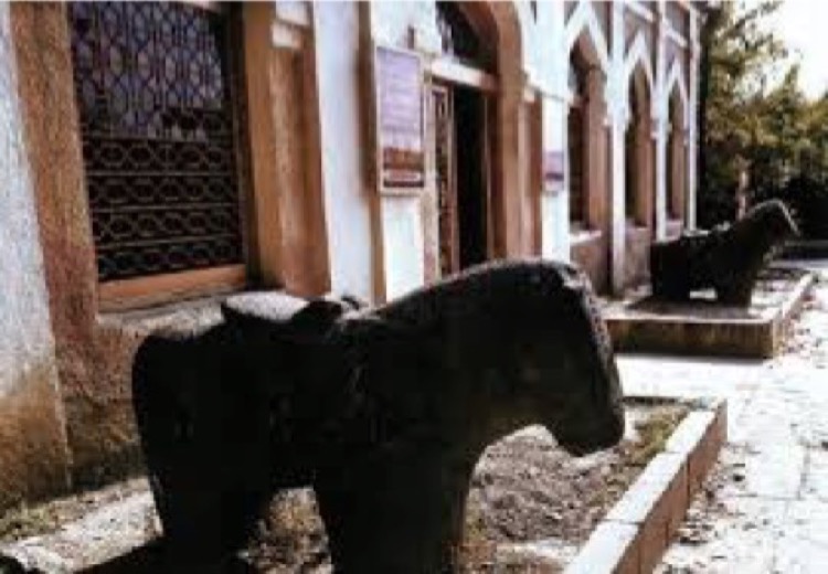
Lachin History and Ethnography Museum functioned from 1974 to May, 1992. The museum was rich with the exhibits of high artistic and historical significance.
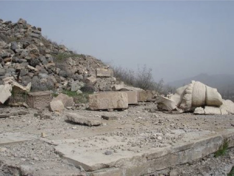
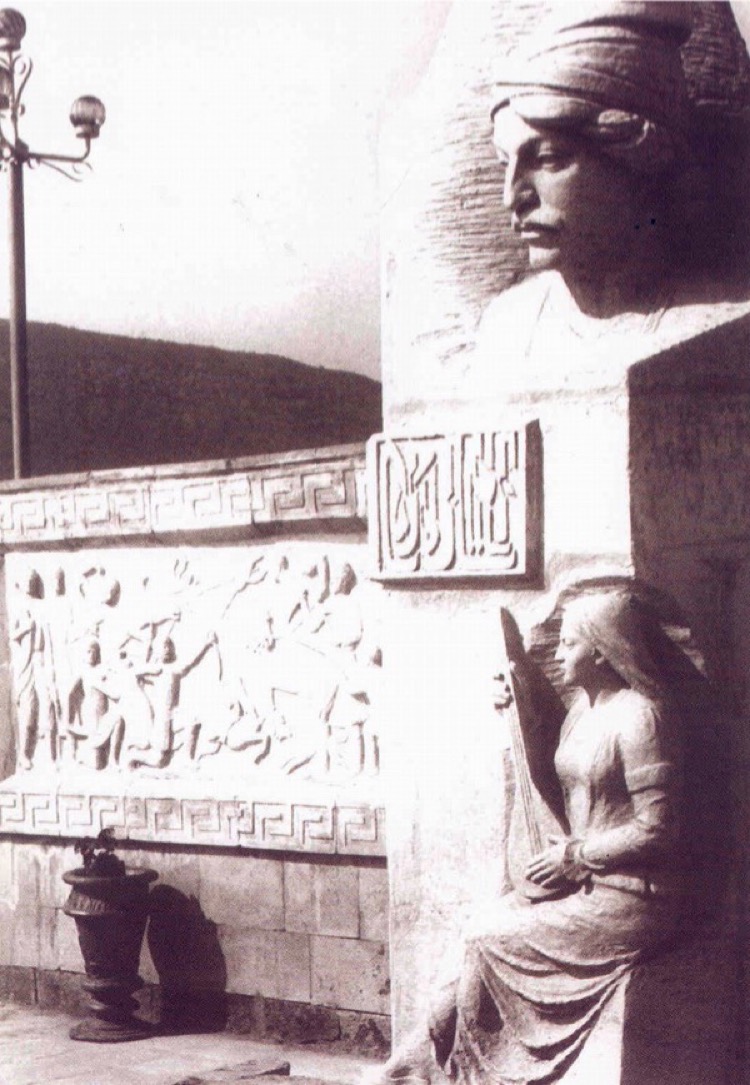
The museum building was considered as a historical and culture monument. Total area of museum was over 1200 sq. meters. The museum consisted of 24 rooms, 1 exhibition hall and a museum collection of 72 sq. meters. Plastic works of art, carvings, statues of horse and ram and very many household items made in different centuries were exhibited in the courtyard of museum. From 1983 to 1992, large-scale expositions were held in museum. More than 5 thousand exhibits were collected in the main fund of museum. A total of about 10 thousand items existed in the museum. Lachin History and Ethnography Museum was a contest winner of the All-Union competition of museums held in 1989. The museum exhibits could not be salvaged during the occupation of Lachin region by the Armenian Armed Forces in May, 1992.
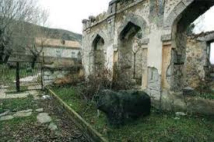
The museum complex was completely destroyed and razed to the ground by Armenian vandals.
Muzeum Historii i Etnografii Lachina
Muzeum Historii i Etnografii Lachina funkcjonowało od 1974 r. Do maja 1992 r. Muzeum było bogate w eksponaty o dużym znaczeniu artystycznym i historycznym.
Budynek muzeum został uznany za zabytek historyczny i kulturowy. Całkowita powierzchnia muzeum wynosiła ponad 1200 metrów kwadratowych. Muzeum składało się z 24 pokoi, 1 sali wystawowej i kolekcji muzealnej o powierzchni 72 m². Na dziedzińcu muzeum eksponowane były plastyczne dzieła sztuki, rzeźby, posągi koni i barana oraz bardzo wiele artykułów gospodarstwa domowego wykonanych w różnych stuleciach. W latach 1983-1992 ekspozycje na dużą skalę odbywały się w muzeum. Ponad 5 tysięcy eksponatów zgromadzono w głównym funduszu muzeum. W sumie w muzeum istniało około 10 tysięcy przedmiotów. Muzeum Historii i Etnografii Lachina było laureatem ogólnokrajowego konkursu muzeów, który odbył się w 1989 roku. Eksponatów muzealnych nie udało się uratować podczas okupacji regionu Lachin przez Armeńskie Siły Zbrojne w maju 1992 roku.
Kompleks muzealny został całkowicie zniszczony i zrównany z ziemią przez armeńskich wandali.
Memorial Museum of Sari Ashiq
In 1988, the memorial museum of the bayati (a kind of Azerbaijani poem created by people) master Sari Ashiq lived in the 12th century, was opened in Gulabird village of Lachin region. At that time, a total of 150 items reminiscent of Sari Ashiq were handed over to the museum. The monument of Sari Ashiq was erected there.
As a result of the occupation of Lachin region by the Armenian Armed Forces in 1992, the museum building and nearly 200 exhibits were destroyed and plundered.
W wyniku okupacji regionu Lachin przez Armeńskie Siły Zbrojne w 1992 r. Budynek muzeum i prawie 200 eksponatów zostało zniszczonych i splądrowanych.
Region Lachin
Zasięg języka Azerskiego (Ozyryjskiego – według nomenklatury Królestwa SIS) – kolor niebieski, zasięg języka Ormiańskiego (Orojskiego) – czerwone pasy.